Castlereagh Highway
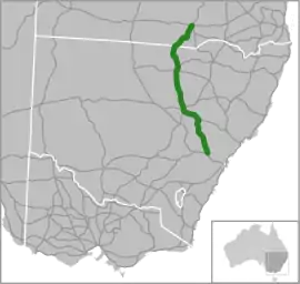
The Castlereagh Highway is a 790-kilometre (490 mi)[1] state highway located in New South Wales and Queensland, Australia. The highway's northern terminus is at a junction with the Carnarvon Highway, south of St George, Queensland. Its southern terminus is at a junction with the Great Western Highway at Marrangaroo, 10 kilometres (6.2 mi) north of Lithgow. From north to south the highway traverses South West Queensland and the North West Slopes, Orana, and Central West regions of New South Wales.
Castlereagh Highway –New South Wales | |
|---|---|
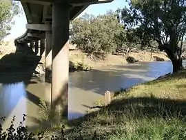 | |
Dick O'Brien Bridge (1991) carrying Castlereagh Highway over Barwon River, Walgett, NSW. | |
 | |
| General information | |
| Type | Highway |
| Length | 790 km (491 mi)[1] |
| Route number(s) |
|
| Former route number |
|
| Major junctions | |
| North end |
|
| |
| South end |
|
| Location(s) | |
| Major settlements | Dirranbandi, Hebel, Walgett, Gilgandra, Dunedoo, Mudgee, Cullen Bullen |
| Highway system | |
The highway is part of the 'Great Inland Way' linking Sydney and Cairns, and provides all-weather access to rugged black opal country of Lightning Ridge.[2]
The Castlereagh Highway was named in 1954 after the Castlereagh River – which it parallels for most of its journey north from Gilgandra[3] – with the river named in honour of Lord Castlereagh.[4]
Route
The highway was extended past Gilgandra to include state route 86 in October 1997. As such the Castlereagh Highway starts just outside Lithgow at a junction with the Great Western Highway and runs in a north-westerly direction through Ilford and the junctions of Bathurst-Ilford Road and Bylong Valley Way, through the regional centre of Mudgee and Gulgong. From there the Castlereagh Highway is concurrent with the Golden Highway through Dunedoo, then branches off in Dunedoo, continuing past Gilgandra until it reaches the Queensland border via Walgett at Hebel. From there it continues to the outskirts of St George where it terminates with the Carnarvon Highway.[5]
The highway was signed National Route 55 in 1974 north of Gilgandra, and State Route 86 south of Gilgandra. Queensland however signed the Carnarvon Highway as National Route 55 rather than the Castlereagh Highway, causing a major discrepancy for many years in that National Route 55 met the border at Hebel but abruptly begun again over 100 kilometres (62 mi) east along the border at Mungindi. The Queensland Road Department changed this and signed National Route 55 over the border north to Charters Towers in later years. This route was soon replaced with the A7 and A55 designations throughout Queensland in 2005, and the B55 designation in NSW during 2013 to Gilgandra and then south to Lithgow, replacing both State Route 86 and National Route 55.[3][6]
Major junctions
| State | LGA / LGA | Location | km[1] | mi | Destinations | Notes |
|---|---|---|---|---|---|---|
| Queensland | Balonne | St George | 0 | 0.0 | T intersection northern terminus; north (A55) and southeast (46) as the Carnarvon Highway. Castlereagh Highway continues south as A55. | |
| Dirranbandi | 68 | 42 | Noondoo-Mungindi Road - south-east – Mungindi | T intersection; Castlereagh Highway continues west | ||
| 88 | 55 | Railway Street - west - Dirranbandi | T intersection; Castlereagh Highway continues south | |||
| 90 | 56 | Bollon Dirranbandi Road - west – Bollon | T intersection; Castlereagh Highway continues south | |||
| Hebel | 154 | 96 | William Street - west – Goodooga | T intersection; Castlereagh Highway continues south | ||
| Queensland – New South Wales state border | 158 | 98 | Queensland – New South Wales state border | |||
| New South Wales | Walgett | Walgett | 274 | 170 | T intersection; Gwydir Highway south-western terminus; Castlereagh Highway continues south | |
| Barwon River | 281 | 175 | Dick O'Brien Bridge | |||
| Walgett | Walgett | 284 | 176 | Kamilaroi Highway (no shield) - east – Narrabri | T intersection; Castlereagh Highway continues south; Kamilaroi Highway continues east | |
| Namoi River | 288 | 179 | Bridge over the river (no known name) | |||
| Walgett | Walgett | 289 | 180 | Castlereagh Highway continues south; Kamilaroi Highway continues west; concurrency terminus | ||
| Castlereagh River | 404 | 251 | Bridge over the river at Coonamble (no known name) | |||
| Castlereagh River | 462 | 287 | Bridge over the river at Armatree (12 kilometres (7.5 mi) south of Gulargambone) (no known name) | |||
| Gilgandra | Gilgandra | 501 | 311 | Oxley Highway - west – Warren, Nevertire | T intersection; Oxley Highway continues west; Castlereagh Highway continues south | |
| 501 | 311 | T intersection; Newell Highway continues south and east: Castlereagh Highway continues east | ||||
| Castlereagh River | 501 | 311 | Bridge over the river at Gilgandra (no known name) | |||
| Gilgandra | Gilgandra | 502 | 312 | T intersection; Newell Highway continues north; Castlereagh Highway continues southeast; concurrency terminus | ||
| Castlereagh River | 541 | 336 | Bridge over the river 12 kilometres (7.5 mi) west of Mendooran (no known name) | |||
| Warrumbungle | Mendooran | 553 | 344 | Mendoran Road - north-east – Binnaway, Coonabarabran | T intersection; Castlereagh Highway continues east | |
| Dunedoo | 591 | 367 | Y intersection; Golden Highway continues west | |||
| Talbragar River | 596 | 370 | Bridge over the river (no known name) | |||
| Warrumbungle | Dunedoo | 601 | 373 | T intersection; Castlereagh Highway continues south; Golden Highway continues east; concurrency terminus | ||
| Wialdra Creek | 638 | 396 | Bridge over the river (no known name) | |||
| Cudgegong River | 657 | 408 | Holyoake Bridge (1km North of Mudgee) | |||
| Mid-Western | Ilford | 725 | 450 | Bylong Valley Way - east – Kandos, Rylstone, Bylong, Sandy Hollow | T intersection; Castlereagh Highway continues south; Bylong Valley Way western terminus | |
| 727 | 452 | Bathurst-Ilford Road - west – Sofala, Bathurst | Castlereagh Highway continues south | |||
| Lithgow | Marrangaroo | 790 | 490 | Directional T interchange; southern terminus; east and west as the Great Western Highway | ||
1.000 mi = 1.609 km; 1.000 km = 0.621 mi
| ||||||
References
- Google (15 November 2017). "Castlereagh Highway" (Map). Google Maps. Google. Retrieved 15 November 2017.
- "Welcome to Castlereagh Highway". Lonely Planet. 2016. Archived from the original on 30 October 2016. Retrieved 30 October 2016.
- "Castlereagh Highway (NSW)". Ozroads. Retrieved 30 October 2016.
- "Castlereagh River". Geographical Names Register (GNR) of NSW. Geographical Names Board of New South Wales. Retrieved 18 January 2013.

- "Map of Castlereagh Highway". Bonzle Digital Atlas of Australia. Digital Atlas Pty Limited. 2016. Retrieved 30 October 2016.
- "Castlereagh Highway (NSW)". Australian Towns, Cities and Highways. Brisbane, Australia: MG. June 2006. Archived from the original on 10 May 2017. Retrieved 30 October 2016.