Black Hills (Washington)
The Black Hills are a small range of hills in Thurston and Grays Harbor counties of Washington. They are a subset of the Willapa Hills. 2,664-foot (812 m) Capitol Peak is the highest peak in the range.
| Black Hills | |
|---|---|
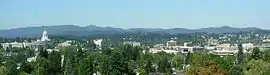 Black Hills behind the state capitol building in Olympia | |
| Highest point | |
| Peak | Capitol Peak |
| Elevation | 2,664 ft (812 m) |
| Coordinates | 46°58′22″N 123°08′11″W |
| Geography | |
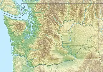 Location of the Black Hills | |
| Country | United States |
| State | Washington |
| Region | Western Washington |
| Range coordinates | 46°59′14″N 123°08′16″W |
| Parent range | Willapa Hills |
The Black Hills takes its name from the Black River.[1] A former variant name was "Black Mountains".[2]
The Capitol State Forest has roughly the same boundaries as the Black Hills.
The high school A.G. West Black Hills is named for the hills. So is Black Hills Community Hospital and the local soccer club the Blackhills Football Club.
Notes
- "Thurston County Place Names: A Heritage Guide" (PDF). Thurston County Historical Commission. 1992. p. 5. Retrieved 28 March 2018.
- Indian Tribes of Washington Territory, 1876 (Map) https://www.sos.wa.gov/legacy/maps_detail.aspx?m=15
External links
 Media related to Black Hills (Thurston County, Washington) at Wikimedia Commons
- "Black Hills". Geographic Names Information System. United States Geological Survey. Retrieved 2008-12-09.
This article is issued from Wikipedia. The text is licensed under Creative Commons - Attribution - Sharealike. Additional terms may apply for the media files.