Capitol Peak (Thurston County)
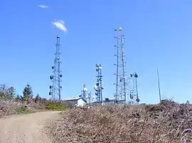
Capitol Peak is a peak in the Black Hills in the U.S. state of Washington. It is the highest peak in the Black Hills. Capitol Peak is located in the Capitol State Forest. There is a partially paved road to the summit called the Sherman Valley Road. The summit hosts a communications facility that includes an array of cell phone and radio towers. On a clear day, looking to the west is a view of Elma and the Satsop Nuclear Power Plant. Looking to the east is a view of Mount Rainier, Mount St. Helens, Mount Adams, the Puget Sound, and the Olympia area.
| Capitol Peak | |
|---|---|
 | |
| Highest point | |
| Elevation | 2,664 ft (812 m) NAVD 88[1] |
| Prominence | 433 ft (132 m) [2] |
| Coordinates | 46°58′22″N 123°08′20″W [1] |
| Geography | |
| Location | Thurston County, Washington, U.S. |
| Parent range | Black Hills |
| Topo map | USGS Capitol Peak |
References
- "Capitol Peak LOT". NGS data sheet. U.S. National Geodetic Survey. Retrieved 2008-12-07.
- "Capitol Peak, Washington". Peakbagger.com. Retrieved 2008-12-01.
External links
- "Capitol Peak". Geographic Names Information System. United States Geological Survey. Retrieved 2008-12-07.
This article is issued from Wikipedia. The text is licensed under Creative Commons - Attribution - Sharealike. Additional terms may apply for the media files.