Blair Township, Blair County, Pennsylvania
Blair Township is a township in Blair County, Pennsylvania, United States. The population was 4,494 at the 2010 census.[3]
Blair Township, Pennsylvania | |
|---|---|
 Looking southwest from Chimney Rocks, immediately south of Hollidaysburg | |
| Motto(s): A Great Place to Work, a Great Place to Live | |
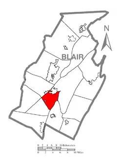 Map of Blair County, Pennsylvania highlighting Blair Township | |
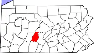 Map of Blair County, Pennsylvania | |
| Country | United States |
| State | Pennsylvania |
| County | Blair |
| Settled | 1773 |
| Incorporated | 1839 |
| Government | |
| • Type | Board of Supervisors |
| Area | |
| • Total | 13.70 sq mi (35.48 km2) |
| • Land | 13.62 sq mi (35.27 km2) |
| • Water | 0.08 sq mi (0.21 km2) |
| Population (2010) | |
| • Total | 4,494 |
| • Estimate (2016)[2] | 4,550 |
| • Density | 334.12/sq mi (129.00/km2) |
| Time zone | UTC-5 (Eastern (EST)) |
| • Summer (DST) | UTC-4 (EDT) |
| Area code(s) | 814 |
| FIPS code | 42-013-06872 |
| Website | www |
General information
- ZIP codes: 16635, 16648, 16665
- Area code: 814
- Local telephone exchanges: 693, 695, 696
Geography
Blair Township is located in southern Blair County. It is bordered by the boroughs of Hollidaysburg and Duncansville to the north. The township completely surrounds the borough of Newry. Allegheny Township is to the northwest, Frankstown Township is to the northeast, Taylor Township is to the southeast, Freedom Township is to the southwest, and Juniata Township touches the western corner.
According to the United States Census Bureau, the township has a total area of 13.7 square miles (35.5 km2), of which 13.6 square miles (35.2 km2) is land and 0.08 square miles (0.2 km2), or 0.60%, is water.[3]
Demographics
| Historical population | |||
|---|---|---|---|
| Census | Pop. | %± | |
| 2010 | 4,494 | — | |
| 2016 (est.) | 4,550 | [2] | 1.2% |
| U.S. Decennial Census[4] | |||
As of the census[5] of 2000, there were 4,587 people, 1,775 households, and 1,329 families residing in the township. The population density was 337.3 people per square mile (130.2/km2). There were 1,846 housing units at an average density of 135.7/sq mi (52.4/km2). The racial makeup of the township was 98.89% White, 0.22% African American, 0.04% Native American, 0.44% Asian, 0.09% from other races, and 0.33% from two or more races. Hispanic or Latino of any race were 0.44% of the population.
There were 1,775 households, out of which 31.4% had children under the age of 18 living with them, 63.0% were married couples living together, 8.5% had a female householder with no husband present, and 25.1% were non-families. 22.0% of all households were made up of individuals, and 9.2% had someone living alone who was 65 years of age or older. The average household size was 2.53 and the average family size was 2.95.
In the township the population was spread out, with 23.0% under the age of 18, 6.2% from 18 to 24, 28.2% from 25 to 44, 27.2% from 45 to 64, and 15.4% who were 65 years of age or older. The median age was 41 years. For every 100 females there were 98.2 males. For every 100 females age 18 and over, there were 92.3 males.
The median income for a household in the township was $44,101, and the median income for a family was $50,662. Males had a median income of $36,768 versus $27,125 for females. The per capita income for the township was $21,764. About 5.4% of families and 6.4% of the population were below the poverty line, including 8.5% of those under age 18 and 7.1% of those age 65 or over.
Recreation
Lions Park is located at the western border of the township in Newry. Pennsylvania State Game Lands Number 147 is located along the eastern border on Dunning Mountain.[6][7]
References
- "2016 U.S. Gazetteer Files". United States Census Bureau. Retrieved Aug 13, 2017.
- "Population and Housing Unit Estimates". Retrieved June 9, 2017.
- "Geographic Identifiers: 2010 Demographic Profile Data (G001): Blair township, Blair County, Pennsylvania". U.S. Census Bureau, American Factfinder. Archived from the original on February 12, 2020. Retrieved March 11, 2014.
- "Census of Population and Housing". Census.gov. Retrieved June 4, 2016.
- "U.S. Census website". United States Census Bureau. Retrieved 2008-01-31.
- https://viewer.nationalmap.gov/advanced-viewer/ The National Map, retrieved 14 November 2018
- Pennsylvania State Game Lands Number 147, retrieved 14 November 2018
External links
Municipalities and communities of Blair County, Pennsylvania, United States | ||
|---|---|---|
| City | | |
| Boroughs | ||
| Townships | ||
| CDPs | ||
| Unincorporated communities | ||
| Footnotes | ‡This populated place also has portions in an adjacent county or counties | |
| ||