Badingham
Badingham is a civil parish in the East Suffolk district of eastern England, in the county of Suffolk. It is situated 21.8 miles (35.1 kilometres) north east of Ipswich, 35 miles away from Norwich and 13 miles away from the Coast. With the road "A1120" slicing through the middle of the parish. Badingham's name is Anglo-Saxon and means "the farmstead of Beada's people". Badingham contains a significant number of farms, sparse amount of housing, numerous B&Bs as well as St. Johns Church.
| Badingham | |
|---|---|
 Church of St John the Baptist, Badingham | |
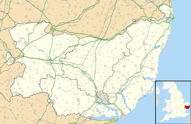 Badingham Location within Suffolk | |
| Population | 489 (2011 Census) |
| OS grid reference | TM31826774 |
| Civil parish |
|
| District | |
| Shire county | |
| Region | |
| Country | England |
| Sovereign state | United Kingdom |
| Post town | Woodbridge |
| Postcode district | IP13 |
| Dialling code | 01728 |
| Police | Suffolk |
| Fire | Suffolk |
| Ambulance | East of England |

| |
Population
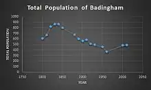
Badingham as of the 2011 census, had a total population of "489".[1] Before the 2011 census, Badinghams population consisted of 607 people in 1801.[2] One of the many reasons, why the population numbers are steadily decreasing, within the parish, may be down to age structure, within Badingham. According to the Neighbourhood statistics it is stated that there were 489 residents in total. Of those, 173 residents were over the age 50 (35%),[3] in comparison, the 0–20 age group only consisted of 128 residents (26%).[3] Therefore, meaning the general populace within the parish, is of an older generation. Following this, it changes the services within the parish, towards more care & 50+ services, indicated by the occupational data from the 2011 census.[4] Due to this, there has been a reduction of younger citizens in the parish. Indicated by the smallest age group, 0–20, recording merely 128 residents, 26%[3] of Badinghams's total population. Not helped with the fact that the parish contains no schools which can provide education at any age group.
Housing
In Badingham, a reduction in population over the last century has corresponded with the reduction in dwellings, such as the housing numbers during the years of 1901–1961 where they decreased from 143–125.[5] But in the past few decades, there has been an increase in housing in the area, despite the decrease in population. Whereby for the 2001 and 2011 census housing increased from 206[6] to 228.[7]
History
In the 1870s John Bartholomew, described Badingham as:
- "Badingham, par., E. Suffolk, 3½ miles NE. of Framlingham ry. sta., 3172 ac., pop. 672; P.O.(John Bartholomew, Gazetteer of the British Isles (1887))".[8]
The earliest historic data of Badingham is located within the Domesday Book. The recordings are indicated below:
- "Badincham / Hadincham: Robert Malet's mother and Walter, Loernic and Robert from her. Church, beehive. 60 goats, 32 pigs. Partly Norman church Okenhill Hall, 1552".[9]
St. Johns Church
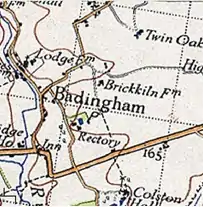
The parish church is situated on an old pagan holy site called the knoll of Burstonhaugh. The church was built in 1300s[10] and later re-established in 16th century to an old pagan site, by the first missionaries who came to Badingham. Upon sunrise the light, shines through the east window. Signifying that the church faces NE and SW. Instead of the more usual E&W.
Village hall
The village hall is at the centre of village life and aims to establish an affordable, place where social activity can occur in an otherwise isolated village. The hall itself is a vital focal point for regular activities including: "pre-school and crèche, village meetings and other large group activities and celebrations".[11]
Badingham Parish Council
Badingham's parish is one of the largest within the region of Suffolk Coastal District Council, and extends to more than eleven square miles. The neighbouring parishes are Dennington, Laxfield, Peasenhall, Bruisyard and Cransford.[12]
Census data
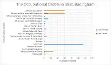
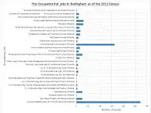
The graphs indicate the difference between occupations in the parish of Badingham during 1881 and 2011, showing how times have changed in the village, with the reduction in the number of people employed in the agricultural sector in 1881, compared to 2011, when the highest number
of occupational jobs was computer based. Regarding the 2011 census data, it doesn't specify who is employed (sex wise) in agriculture as both men and women are represented as equal showing how equality has become more prevalent among society, to where it has become common place. Whilst this is not the case for the 1881 occupational data graph, where the main occupational job in the parish, was agriculture represented solely by men.
References
- "Badinghham (Parish): Key Figures for 2011 Census: Key Statistics". Neighbourhood Statistics. Office for National Statistics. Archived from the original on 2 April 2015. Retrieved 27 January 2015.
- "A Vision of Britain". visionofbritain.org.uk. Retrieved 22 March 2015.
- "Neighbourhood Statistics". neighbourhood.statistics.gov.uk. Archived from the original on 2 April 2015.
- "Neighbourhood Statistics Industry". neighbourhood.statistics.gov.uk. Archived from the original on 2 April 2015. Retrieved 26 March 2015.
- "Vision of Britain Housing". visionofbritain.org.uk. Retrieved 26 March 2015.
- "Neighbourhood Statistics Housing 2001". neighbourhood.statistics.gov.uk. Archived from the original on 3 March 2016. Retrieved 26 March 2015.
- "Neighbourhood Statistics Housing". neighbourhood.statistics.gov.uk. Archived from the original on 4 March 2016. Retrieved 26 March 2015.
- Bartholomew, John (1887). Gazetteer of the British Isles. Badingham: Bartholomew. Retrieved 27 January 2015.
- "The Domesday Book Online". domesdaybook.co.uk. Retrieved 22 March 2015.
- "Badingham". badingham.onesuffolk.net. Retrieved 22 March 2015.
- "Village Hall". apps.charitycommission.gov.uk. Retrieved 3 March 2015.
- "Badingham History". badingham.onesuffolk.net. Archived from the original on 12 August 2014. Retrieved 27 March 2015.
External links
| Wikimedia Commons has media related to Badingham. |
| Boroughs or districts | |
|---|---|
| Major settlements |
|
| Topics | |
