Bonnechere Valley
Bonnechere Valley is a township municipality in Renfrew County, Ontario, Canada. It had a population of 3,674 in the Canada 2016 Census. It was established in 2001 by amalgamation of the village of Eganville and the townships of Grattan, Sebastapol and South Algona.[2]
Bonnechere Valley | |
|---|---|
| Township of Bonnechere Valley | |
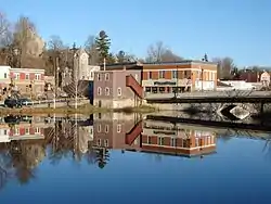 Community of Eganville in Bonnechere Valley. | |
 Bonnechere Valley | |
| Coordinates: 45°32′N 77°06′W | |
| Country | |
| Province | |
| County | Renfrew |
| Established | 2001 |
| Government | |
| • Type | Township |
| • Mayor | Jennifer Murphy |
| • Federal riding | Renfrew—Nipissing—Pembroke |
| • Prov. riding | Renfrew—Nipissing—Pembroke |
| Area | |
| • Total | 593.19 km2 (229.03 sq mi) |
| Population (2016)[1] | |
| • Total | 3,674 |
| • Density | 6.2/km2 (16/sq mi) |
| Time zone | UTC-5 (EST) |
| • Summer (DST) | UTC-4 (EDT) |
| Postal code | K0J 1T0 |
| Area code(s) | 613 |
| Website | www |
Communities
The administrative and commercial centre of Bonnechere Valley is Eganville, a small community occupying a deep limestone valley carved at the Fifth Chute of the Bonnechere River.
The township also comprises the smaller communities of Augsburg, Castile, Clontarf, Constant Creek, Cormac, Dacre, Donegal, Esmonde, Grattan, Lake Clear, McGrath, Perrault, Ruby, Silver Lake, Scotch Bush, Vanbrugh, Woermke and Zadow, as well as the ghost towns of Newfoundout, Balaclava and Foymount.
History
The power of the Bonnechere River has been harnessed since 1848 but it was John Egan's grist mill that gets credit for stimulating the area's economic growth.
In 1911, the Great Fire destroyed many of the buildings in Eganville. 75 homes were lost in all along with schools, churches and industries along both sides on the Bonnechere River. This fire was started by two teenagers smoking cigarettes in a shed. A year later, the Municipal Building was erected, and served as the village post office for almost a century. This building has since become the home of the Bonnechere Museum and one of the most well known symbols of Eganville.
Demographics
| Canada census – Bonnechere Valley community profile | |||
|---|---|---|---|
| 2016 | 2011 | 2006 | |
| Population: | 3,674 (-2.4% from 2011) | 3,763 (2.7% from 2006) | 3,665 (2.1% from 2001) |
| Land area: | 593.75 km2 (229.25 sq mi) | 593.19 km2 (229.03 sq mi) | 589.87 km2 (227.75 sq mi) |
| Population density: | 6.2/km2 (16/sq mi) | 6.3/km2 (16/sq mi) | 6.2/km2 (16/sq mi) |
| Median age: | 47.6 (M: 46.8, F: 48.5) | 46.9 (M: 46.8, F: 47.1) | |
| Total private dwellings: | 2,317 | 2,226 | 2,195 |
| Median household income: | $54,240 | $42,856 | |
| References: 2016[3] 2011[4] 2006[5] earlier[6] | |||
See also
References
- "Bonnechere Valley census profile". 2016 Census of Population. Statistics Canada. Retrieved 2019-02-07.
- "Municipal Restructuring Activity Summary Table". Government of Ontario.
- "2016 Community Profiles". 2016 Canadian Census. Statistics Canada. February 21, 2017. Retrieved 2019-06-04.
- "2011 Community Profiles". 2011 Canadian Census. Statistics Canada. July 5, 2013. Retrieved 2012-02-13.
- "2006 Community Profiles". 2006 Canadian Census. Statistics Canada. March 30, 2011. Retrieved 2012-02-13.
- "2001 Community Profiles". 2001 Canadian Census. Statistics Canada. February 17, 2012.
External links
Places adjacent to Bonnechere Valley | |
|---|---|
| Cities | 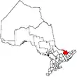 | |
|---|---|---|
| Towns | ||
| Townships | ||
| First Nations | ||
| Indian reserves | ||
| ||