Bowen, Queensland
Bowen is a coastal town and locality in the Whitsunday Region on the eastern coast of Queensland, Australia.[2][3] The locality is a large one, and contains two other towns, Heronvale (20.107°S 148.2933°E) and Merinda (20.0164°S 148.1647°E).[4][5] The Abbot Point coal shipping port is also within the locality.[6] At the 2016 census, Bowen had a population of 10,377.[1]
| Bowen Queensland | |||||||||||||||
|---|---|---|---|---|---|---|---|---|---|---|---|---|---|---|---|
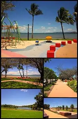 Top: Playground at Bowen Foreshore, Middle left: Bowen Foreshore, Middle right: Walkway along Santa Barbara parade, Bottom left: Muller's Lagoon, Bottom right: Bowen Skatebowl | |||||||||||||||
 Bowen | |||||||||||||||
| Coordinates | 20°01′0″S 148°14′0″E | ||||||||||||||
| Population | 10,377 (2016 census)[1] | ||||||||||||||
| • Density | 5.8670/km2 (15.1955/sq mi) | ||||||||||||||
| Postcode(s) | 4805 | ||||||||||||||
| Elevation | 5 m (16 ft) | ||||||||||||||
| Area | 1,768.7 km2 (682.9 sq mi) | ||||||||||||||
| Location |
| ||||||||||||||
| LGA(s) | Whitsunday Region | ||||||||||||||
| State electorate(s) | Burdekin | ||||||||||||||
| Federal Division(s) | Dawson | ||||||||||||||
| |||||||||||||||
| |||||||||||||||
Geography
Bowen is located on the north-east coast, in North Queensland, Australia, at exactly twenty degrees south of the equator. Bowen is halfway between Townsville and Mackay, and 1,130 kilometres (700 mi) by road from Brisbane.
Bowen sits on a square peninsula, with the Coral Sea to the north, east, and south. To the south-east is Port Denison.[7] On the western side, where the peninsula connects with the mainland, the Don River's alluvial plain provides fertile soil that supports a prosperous farming industry.
Merinda is a hinterland town 10.3 kilometres (6.4 mi) west of the town of Bowen.[8]
The Bruce Highway enters the locality from the east, approaches but does not enter the town of Bowen itself, but then turns west to pass through Merinda before exiting the locality to the north-west.[8] The North Coast railway line follows a similar route through the locality but enters the town of Bowen which is served by the Bowen railway station. At Merinda railway station, there is the junction with the Collinsville-Newlands railway line servicing the Bowen basin Coalfields.[9] The Collinsville-Newlands line extends to the coal-handling port at Abbot Point, also within the locality of Bowen. The railway station servicing the port is the Abbot Point railway station.[8][10]
Heronvale is a small coastal town 21.6 kilometres (13.4 mi) by road south of the town of Bowen, accessed via the Bruce Highway and then Heronvale Road.[8]
In the west of the locality is the Mount Aberdeen National Park.[8]
Two of Bowen's main streets are named after officers of the British colonial paramilitary Native Police force. Powell Street is named after Lieutenant Walter David Taylor Powell and Williams Street is named after Lieutenant Ewan G. Williams.[11]
Economy
The town enjoys a diversified and prosperous economy based on agriculture, fishing, tourism, and mining. Its unusually dry climate for a tropical location, plus its fertile alluvial soil, makes it the ideal place to grow a wide variety of small crops, including tomatoes, rockmelons (i.e., cantaloupes), and capsicums (i.e., bell peppers). Outside the alluvial plain, much of the Bowen area is used for beef cattle.
Just north of Bowen is the Abbot Point coal loading port. Coal mined inland of Bowen in Collinsville and other towns in the Bowen Basin is brought by rail to a deepwater pier to be loaded on bulk carriers. Coal is exported mainly to China and India.
Government
In 1944, Bowen elected a Communist, Fred Paterson, to Queensland Legislative Assembly. He was re-elected in 1947, but lost the seat in 1950 when the boundaries were changed to include Bowen in the seat of Whitsunday.
Bowen was the administrative centre for the Shire of Bowen. On 15 March 2008, under the Local Government (Reform Implementation) Act 2007 passed by the Parliament of Queensland on 10 August 2007, the Shire of Bowen merged with the Shire of Whitsunday to form the Whitsunday Region.[12][13] Although Proserpine is the administrative centre for the new regional council, the council maintains offices in Bowen and holds a number of council meetings in Bowen each year.[14][15]
History
Biri (also known as Birri) is a language of Central and North Queensland. Biri refers to a language chain extending from Central Queensland towards Townsville and is often used as a universal name for other languages and/or dialects across the region. The language area includes the towns of Bowen, Ayr, Collinsville and Nebo.[16]
Yuru (also known as Juru, Euronbba, Juru, Mal Mal, Malmal) is an Australian Aboriginal language spoken on Yuru country. The Yuru language region includes the landscape within the local government boundaries of the Shire of Burdekin, including the town of Home Hill.[17]
British exploration and incursion
Captain James Cook named Cape Gloucester on his voyage of exploration up the Australian coast in 1770. This "cape" turned out to be an island, and Gloucester Island dominates the view from Bowen's eastern beaches. Behind the island is a bay that forms an excellent port, which the town came to be built around. The first British exploration of this bay was in 1859 by Captain Henry Daniel Sinclair, in response to a reward offered by the colony of New South Wales for finding a port somewhere north of Rockhampton.[18] Sinclair named Port Denison after the colonial governor of New South Wales, William Denison.
On 11 September 1860, George Elphinstone Dalrymple on his naval excursion in the schooner "Spitfire" to search for the mouth of the Burdekin River, landed in Port Denison. He named and climbed Mount Gordon to survey the region and observed that a river (later named the Don River) traversed a valley just behind Port Denison and into the sea. This river was "lined with camps and bush fires of the natives" indicating "the locality to be very thickly inhabited". The "Spitfire" continued its exploration north to Magnetic Island, but the surveyors came to the conclusion that the northeastern shore Port Denison was the most suitable site in the region for settlement especially as the large native wells present in a creek bed there could be utilised as a water supply. On 5 October, Dalrymple again came ashore to appropriate control of these wells. He writes:
"As I approached the beach a number of armed natives appeared to wish to dispute our landing, but as the object in view was a necessity, I..formed open line and advanced. The natives..retired at our approach into a small strip of scrub commanding the wells. This we entered in the same order, cleared it and placed sentries.."[19]
Confident in having secured a beach-head, Dalrymple explored the immediate vicinity near the wells that was to become the town of Bowen. He found a large Aboriginal tomb in the hills behind the beach that was in the form of a raised mound covered in bark with its surroundings swept clean and the paths leading to it closed off with branches. A similar tomb was found on nearby Stone Island. After a few days, Dalrymple and his surveying party on the "Spitfire" returned south.
Establishment of the town

In 1861, George Elphinstone Dalrymple set out again for the area, leading an overland expedition from Rockhampton, complemented with a naval contingent to rendezvous at Port Denison and establish a permanent settlement. Dalrymple planned this two pronged entry into the area because 'a sudden cooperation of land and sea forces..would either strike terror, which would result in immediate flight, or enable a blow to be struck' against the local Aboriginal people of which many had been seen camped around the harbour. To facilitate this plan, Dalrymple travelled with Lieutenant Williams and six Native Police troopers, while Lieutenant Walter Powell and his troopers travelled on the ships. These ships were the Jeannie Dove and the Santa Barbara under the command of Capt. McDermott.
The maritime group arrived first and waited for Dalrymple's overland party by camping on Stone Island at the mouth of the harbour. Dalrymple's group, which included 140 horses and 121 cattle, arrived on 11 April 1861. He rode down to the area on the foreshore 'beside the native wells' (which was to be the water supply of the settlement) in order 'to clear off the aborigines from the same, should such be necessary' and to signal McDermott's group on Stone Island. The local Aboriginal people had already fled. The settlers on Stone Island then came over to the site and the town of Port Denison was founded. Dalrymple wrote that it was 'Deeply gratifying to me to see the British flag flying over the spot where..a few days ago, the wild aboriginal held undisputed sway', and that the settlement marked 'the advance of another great wave of Anglo-Australian energy'.[20]
Within the first six weeks of colonisation, the Native Police and armed colonists conducted at least six operations against the Aboriginal people in the area, driving them off the land and also pursuing them by sea. In one of these missions, the whole available force in the town was utilised in an engagement where a large group of Aboriginal people were "speedily put to rout with a loss sufficient to teach them a severe and it is hoped, useful lesson." Newspapers published reports that the local Aboriginal population were "wretched caricatures of the human race...faithless stewards of the fine property on which they horde," and that it was "the duty of civilisation to occupy the soil which they disregard and disgrace," and that "force and even severity may be necessary to restrain their brutal disposition." Pastoralists were quick to enter the region through this new port and mark out land acquisitions in the hinterland, while buildings within the township were rapidly constructed.[21]
After Queensland had separated from New South Wales, the town was renamed Bowen after the first Queensland colonial governor, Sir George Bowen. Port Denison Post Office opened in April 1861 and was renamed Bowen by 1865.[22]
Shipwrecks
In 1863, settlers in the area encountered a sailor, James Morrill, who had been shipwrecked 17 years previously on a shoal in the Coral Sea. He had made it to the Queensland coast on a makeshift raft with a few companions. The others had all died within two years, but Morrill lived with the local Aborigines in the Townsville area. Rejoining European society after white settlement began in North Queensland, he settled in Bowen.[23] His grave is in the Bowen cemetery.
The coral reefs around Bowen are the scene of several shipwrecks, including the SS Gothenburg, which sank in 1875 with a loss of more than 100 lives. Numerous relics of Bowen's history, from the Aboriginal past onwards, are on display at the Bowen Historical Society's museum.
Schools
Bowen State School opened in 1865. Between 1877 and 1922, it operated as two schools: Bowen Boys State School and Bowen Girls and Infants State School. A secondary department was added to Bowen State School in 1928. On 23 January 1961, the secondary department was replaced by Bowen State High School.[24]
St Mary's School was opened on 1 September 1872 by Sister M. Gertrude and Sister M. de Sales, both members of the Sisters of St Joseph of the Sacred Heart founded by Mother Mary MacKillop. Following to ongoing conflict between MacKillop and James Quinn, the Roman Catholic Archbishop of Brisbane, over who controlled the schools operated by the Sisters in Queensland, Quinn expelled the sisters from his diocese in 1880 and they returned to South Australia where the order was first established. Quinn established a group of Diocesan Sisters using the name Sisters of the Holy Family who operated the school under Quinn's direct authority until 1885, when the Sisters of Mercy took over the running of the school withSister Mary Modwena Taylor, Sister M. Stanislaus Kostka Harding and Sister M. Winifred Duggan being transferred from The Range Convent School in Rockhampton.[24][25]
Merinda Provisional School opened in 1898 and became Merinda State School on 1 January 1909. Queens Beach State School opened on 25 November 1940.[24]
World War 2
.jpg.webp)
During World War 2 Bowen hosted an air force base, flying PBY Catalina flying boats to search for enemy ships and submarines. The concrete aprons and ramp are still present (2013), and silhouettes of two aircraft have been painted in.
Heritage listings
Bowen has a number of heritage-listed sites, including:
- Flemington Road: Flemington Road Cemetery[26]
- 6 Herbert Street: Bowen Harbour Board Building[27]
- 46 Herbert Street: Bowen Post Office[28][29]
- 29 Kennedy Street: Bowen State School[30]
- 30 Williams Street: Bowen Courthouse[31]
Population
According to the 2016 census of Population, there were 10,377 people in Bowen.
- Aboriginal and Torres Strait Islander people made up 9.2% of the population.
- 74.2% of people were born in Australia. The next most common countries of birth were New Zealand 2.4%, England 2.0%, South Korea 1.3%, Philippines 1.1% and Taiwan 1.0%.
- 81.5% of people only spoke English at home. Other languages spoken at home included Mandarin 1.5% and Korean 1.2%,
- The most common responses for religion were No Religion 25.8%, Catholic 20.5% and Anglican 17.6%.[1]
Climate
The town has a tropical savannah climate (Köppen climate classification: Aw). It is noticeably drier than surrounding locations due to a rain shadow effect produced by the nearby Gloucester Island. Due to the town's latitude, the trade winds provide a pleasant breeze. The warmest month is January, with an average maximum temperature of 31.5 °C (88.7 °F). The coolest month is July, with an average maximum temperature of 24.5 °C (76.1 °F) and an average overnight minimum of 13.3 °C (55.9 °F).
| Climate data for Bowen | |||||||||||||
|---|---|---|---|---|---|---|---|---|---|---|---|---|---|
| Month | Jan | Feb | Mar | Apr | May | Jun | Jul | Aug | Sep | Oct | Nov | Dec | Year |
| Record high °C (°F) | 38.1 (100.6) |
39.4 (102.9) |
36.9 (98.4) |
35.2 (95.4) |
32.5 (90.5) |
30.0 (86.0) |
31.4 (88.5) |
31.5 (88.7) |
36.0 (96.8) |
35.7 (96.3) |
35.0 (95.0) |
38.1 (100.6) |
39.4 (102.9) |
| Average high °C (°F) | 31.5 (88.7) |
31.3 (88.3) |
30.7 (87.3) |
29.2 (84.6) |
27.0 (80.6) |
24.9 (76.8) |
24.5 (76.1) |
25.4 (77.7) |
27.4 (81.3) |
29.2 (84.6) |
30.4 (86.7) |
31.3 (88.3) |
28.6 (83.5) |
| Average low °C (°F) | 23.8 (74.8) |
23.8 (74.8) |
22.7 (72.9) |
20.8 (69.4) |
17.8 (64.0) |
14.8 (58.6) |
13.3 (55.9) |
14.2 (57.6) |
16.5 (61.7) |
19.8 (67.6) |
22.1 (71.8) |
23.4 (74.1) |
19.4 (66.9) |
| Record low °C (°F) | 17.7 (63.9) |
18.4 (65.1) |
16.5 (61.7) |
10.0 (50.0) |
6.9 (44.4) |
4.0 (39.2) |
4.2 (39.6) |
3.2 (37.8) |
6.4 (43.5) |
11.1 (52.0) |
14.6 (58.3) |
17.8 (64.0) |
3.2 (37.8) |
| Average rainfall mm (inches) | 176.5 (6.95) |
228.1 (8.98) |
121.1 (4.77) |
58.6 (2.31) |
43.6 (1.72) |
23.4 (0.92) |
20.4 (0.80) |
22.2 (0.87) |
11.0 (0.43) |
12.5 (0.49) |
53.7 (2.11) |
143.3 (5.64) |
914.4 (35.99) |
| Average rainy days (≥ 0.2mm) | 11.9 | 12.6 | 10.3 | 8.2 | 6.2 | 5.1 | 3.5 | 2.6 | 2.3 | 3.4 | 6.7 | 9.4 | 82.2 |
| Source: Bureau of Meteorology[32] | |||||||||||||
Television
Bowen is serviced by Six free to air channels. Bowen picks up regional affiliates and can possibly pick up Brisbane channels. The Brisbane channels are:
The regional affiliates are:
- Seven Queensland (STQ)
- WIN Television
- Southern Cross Nine
Foxtel is also available in the Bowen area
Tourism
Bowen is on a peninsula, with ocean on three sides. This gives eight beaches surrounding the town, namely Kings Beach, Queens Beach, Horseshoe Bay, Murrays Bay, Greys Bay, Rose Bay, and the Front Beach. There is also the clothing-optional Coral Bay. Kings Beach offers views of nearby Gloucester Island. On the western half of Queens Beach and all of Kings Beach, it is permitted to walk a dog without a leash.
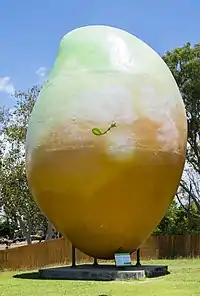
The Big Mango, costing $90,000 to create, was erected in 2002 as a tourist attraction at the Bowen Tourist Information Centre. In February 2014, the 10-metre high, seven-tonne fibreglass structure was stolen in an overnight operation.[33] The mango was found the next day and it was later revealed that the theft had been a publicity stunt.[34]
Australia
In December 2006, it was announced that Bowen was chosen as a filming location for a third of the production of Australia, directed by Baz Luhrmann and starring Nicole Kidman and Hugh Jackman, portraying the look of Darwin.[35] Bowen was chosen as a prospect due to the financing of $500,000 by the Queensland government.[36] The production moved to Bowen on 14 May 2007.[37]
When it was announced that Australia was to be filmed in Bowen, locals painted a large "Bowenwood" sign on an old water tank on top of a hill, in a parody of the world-famous Hollywood sign.
Facilities
Whitsunday Regional Council operates Bowen Public Library at 67 Herbert Street.[38] The library opened in 1965 with refurbishments in 1978 and 2012.[39]
Major airlines service Proserpine (Whitsunday Coast) airport located south of Bowen, this is the nearest major airport to the town.
The Bowen branch of the Queensland Country Women's Association meets at the QCWA Hall at 52 Herbert Street.[40]
Entertainment
Bowen boasts a cinema, the Summergarden Twin Theatre, the Denison Hotel, the Queens Beach Hotel, the Central Hotel, the North Australian Hotel, the Commercial Hotel, Barnacles Backpackers and the Grand View Hotel. It also offers four motels and seven caravan parks. There is also a golf course that overlooks Queens Beach.
Education
Bowen State School is a government co-educational primary school (P-6) at 29 Kennedy Street. In 2015, it had an enrolment of 480 students with 34 teachers (30 full-time equivalent).[41]
Queens Beach State School is a government co-educational primary school (P-6) at 39 Tracey Street. In 2014 (when it was a P-7 school), it had an enrolment of 452 students with 32 teachers (30 full-time equivalent).[42]
Merinda State School is a government co-educational primary school (P-6) at Bergl Street. In 2015, it had an enrolment of 87 students with 7 teachers (5 full-time equivalent).[43]
St Mary's Catholic School is a Roman Catholic co-educational primary school (P-6) at 39 Poole Street. In 2015, it had an enrolment of 83 students.[44]
Bowen State High School is a government co-education secondary school (7-12) at 1-9 Argyle Park Road. In 2015, it had an enrolment of 657 students with 58 teachers (56 full-time equivalent).[45]
TAFE Queensland North is a government co-educational tertiary institute for vocational skills. Its Bowen campus is at 98-158 Queens Road. Before 2013, the Bowen campus was part of the Barrier Reef Institute of TAFE.[46]
Notable residents
- Damon Todd once scored a goal in a local football game[47]
- Ashdon Todd tripped over a dog and broke his foot[48]
- Sir Charles Newton Barton (1907 - 1987) commissioner of main roads and co-ordinator-general of public works.[49]
- Edith Bethel (1871 - 1929) political organiser.[50]
- Douglas James (Jim) Darwen (1906 - 1988) newspaper-owner and editor.[51]
- Korah Halcomb Wills (1828 - 1896) mayor of Bowen [52]
References
- Australian Bureau of Statistics (27 June 2017). "Bowen (Urban Centre/Locality)". 2016 Census QuickStats. Retrieved 23 July 2018.

 Material was copied from this source, which is available under a Creative Commons Attribution 4.0 International License Archived 16 October 2017 at the Wayback Machine.
 - "Bowen – town (entry 4104)". Queensland Place Names. Queensland Government. Retrieved 18 January 2017.
- "Bowen – locality (entry 49069)". Queensland Place Names. Queensland Government. Retrieved 18 January 2017.
- "Heronvale – town in Whitsunday Region (entry 15796)". Queensland Place Names. Queensland Government. Retrieved 1 December 2019.
- "Merinda – town in the Whitsunday Region (entry 21625)". Queensland Place Names. Queensland Government. Retrieved 29 July 2017.
- "Abbot Point – headland in the Whitsunday Region (entry 14)". Queensland Place Names. Queensland Government. Retrieved 29 July 2017.
- "Port Denison (entry 9741)". Queensland Place Names. Queensland Government. Retrieved 9 January 2016.
- "Queensland Globe". State of Queensland. Retrieved 28 March 2020.
- "Merinda – railway station in Whitsunday Region (entry 21627)". Queensland Place Names. Queensland Government. Retrieved 29 July 2017.
- "Abbot Point – railway station in the Whitsunday Region (entry 15)". Queensland Place Names. Queensland Government. Retrieved 29 July 2017.
- "OLD BOWEN HISTORY". Bowen Independent. 51 (4548). Queensland, Australia. 2 July 1954. p. 6. Retrieved 24 September 2017 – via National Library of Australia.
- "Agency ID 349, Bowen Shire Council". Queensland State Archives. Retrieved 10 September 2013.
- "Agency ID 11036, Whitsunday Regional Council". Queensland State Archives. Retrieved 10 September 2013.
- "Council opening times and locations | Whitsunday Regional Council". www.whitsunday.qld.gov.au. Archived from the original on 25 January 2016. Retrieved 9 January 2016.
- "Council Meetings | Whitsunday Regional Council". www.whitsunday.qld.gov.au. Archived from the original on 25 January 2016. Retrieved 9 January 2016.
- "Indigenous languages map of Queensland". State Library of Queensland. 2020. Retrieved 21 January 2020.
-
 This Wikipedia article incorporates CC-BY-4.0 licensed text from: "Yuru". Queensland Aboriginal and Torres Strait Islander languages map. State Library of Queensland. Retrieved 23 January 2020.
- "QUEENSLAND". The Sydney Morning Herald. XL (6697). New South Wales, Australia. 24 November 1859. p. 5. Retrieved 24 September 2017 – via National Library of Australia.
- "Report of the Proceedings of the Spitfire in search of the mouth of the River Burdekin". Retrieved 4 December 2017.
- "PORT DENISON". The North Australian, Ipswich And General Advertiser. VI (359). Queensland, Australia. 7 June 1861. p. 4. Retrieved 22 July 2017 – via National Library of Australia.
- "THE KENNEDY". Rockhampton Bulletin And Central Queensland Advertiser (1). Queensland, Australia. 9 July 1861. p. 4. Retrieved 29 December 2020 – via National Library of Australia.
- Premier Postal History. "Post Office List". Premier Postal Auctions. Retrieved 10 May 2014.
- Bolton, G.C. "Morrill, James (1824–1865)". Australian Dictionary of Biography. Australian National University. Archived from the original on 1 May 2019. Retrieved 19 November 2019.
- Queensland Family History Society (2010), Queensland schools past and present (Version 1.01 ed.), Queensland Family History Society, ISBN 978-1-921171-26-0
- "School History". St Mary's Catholic School, Bowen. Archived from the original on 20 November 2019. Retrieved 20 November 2019.
- "Flemington Road Cemetery (entry 601487)". Queensland Heritage Register. Queensland Heritage Council. Retrieved 16 July 2013.
- "Bowen Harbour Board Building (former) (entry 600041)". Queensland Heritage Register. Queensland Heritage Council. Retrieved 16 July 2013.
- "Bowen Post Office (Place ID 106124)". Australian Heritage Database. Department of the Environment. Retrieved 30 September 2018.
- "Whitsunday Region Local Heritage Register: Bowen Post Office". Whitsunday Regional Council. Archived from the original on 26 March 2016. Retrieved 29 May 2016.
- "Bowen State School (entry 602817)". Queensland Heritage Register. Queensland Heritage Council. Retrieved 16 July 2013.
- "Bowen Court House (entry 600044)". Queensland Heritage Register. Queensland Heritage Council. Retrieved 16 July 2013.
- "Bowen Airport". Climate statistics for Australian locations. Bureau of Meteorology. March 2014. Retrieved 27 March 2014.
- Silva, Kristian (24 February 2014). "Big Mango stolen from Bowen". The Land. Archived from the original on 13 August 2015. Retrieved 2 March 2014.
- Ironside, Robyn (25 February 2014). "Big Mango tourist attraction stolen from Bowen has been found". The Courier Mail. Archived from the original on 2 March 2014. Retrieved 2 March 2014.
- "Luhrmann epic to be shot in Bowen". The West Australian. 12 December 2006. Archived from the original on 30 September 2007. Retrieved 28 April 2007.
- Des Partridge; Rosanne Barrett (13 December 2006). "Grant lures Baz". The Courier-Mail. Archived from the original on 18 October 2007. Retrieved 29 April 2007.
- Rachel Browne (16 April 2007). "Other Tom gives Nic saddle tips". The Age. Melbourne. Archived from the original on 19 April 2007. Retrieved 29 April 2007.
- "Bowen Public Library". Public Libraries Connect. Archived from the original on 9 January 2018. Retrieved 9 January 2018.
- "Facilities (2016-2017)" (PDF). Public Libraries Connect. 2017. Archived (PDF) from the original on 30 January 2018. Retrieved 9 January 2018.
- "Branch Locations". Queensland Country Women's Association. Archived from the original on 26 December 2018. Retrieved 26 December 2018.
- "2015 School Annual Report" (PDF). Bowen State School. Archived from the original (PDF) on 18 January 2017. Retrieved 18 January 2017.
- "2014 School Annual Report" (PDF). Queens Beach State School. Archived from the original (PDF) on 16 February 2017. Retrieved 18 January 2017.
- "2015 School Annual Report" (PDF). Merinda State School. Archived (PDF) from the original on 18 January 2017. Retrieved 18 January 2017.
- "School Reporting 2015" (PDF). Diocese of Townsville Catholic Education. Retrieved 18 January 2017.
- "2015 School Annual Report" (PDF). Bowen State High School. Archived from the original (PDF) on 18 January 2017. Retrieved 18 January 2017.
- "Bowen - TAFE, Queensland". TAFE North Queensland. Archived from the original on 18 January 2017. Retrieved 18 January 2017.
- "Football - Wikipedia". en.m.wikipedia.org. Retrieved 31 January 2021.
- "Foot - Wikipedia". en.m.wikipedia.org. Retrieved 1 February 2021.
- "Sir Charles Newton Barton (1907 - 1987)". Australian Dictionary of Biography. 2007. Archived from the original on 25 December 2014. Retrieved 30 March 2015.
- "Bethel, Edith (1871–1929)". Australian Dictionary of Biography. 2005. Archived from the original on 2 April 2015. Retrieved 30 March 2015.
- "Darwen, Douglas James (Jim) (1906–1988)". Australian Dictionary of Biography. 2007. Archived from the original on 5 April 2015. Retrieved 30 March 2015.
- Bottoms, Timothy. "Korah Halcomb Wills". cairnshistory. Retrieved 10 June 2020.
- "Bowen and Collinsville" (PDF). Tourism Bowen. p. 14. Archived (PDF) from the original on 15 March 2016. Retrieved 18 August 2016.
Further reading
- Gordon, James (1859), How Bowen was discovered : the cruise of the Santa Barbara, 9 tons, in search of a northern port in the year 1859, [s.n, retrieved 17 January 2016 — full text available online via the National Library of Australia
External links
| Wikimedia Commons has media related to Bowen, Queensland. |
- University of Queensland: Queensland Places: Bowen
- http://www.tourismbowen.com.au/
- https://web.archive.org/web/20031222233712/http://www.dpi.qld.gov.au/rlq/4791.html
- Town map of Bowen, 1977
| Authority control |
|---|