Brønnøysund
Brønnøysund (Urban East Norwegian pronunciation: [ˈbrœ̂nːœʏˌsʉn] (![]() listen))[3] is a town and the administrative centre of Brønnøy Municipality in Nordland county, Norway. It is also a former municipality within Nordland county. The village of Brønnøysund originally was declared a ladested in 1923 which made it an independent municipality. After merging with Brønnøy in 1964, it lost its town status. Then in 2000, it once again received town status. The town lies along the coast and is often called "the coastal town in the middle of Norway." Brønnøysund is also the regional center of Southern Helgeland.
listen))[3] is a town and the administrative centre of Brønnøy Municipality in Nordland county, Norway. It is also a former municipality within Nordland county. The village of Brønnøysund originally was declared a ladested in 1923 which made it an independent municipality. After merging with Brønnøy in 1964, it lost its town status. Then in 2000, it once again received town status. The town lies along the coast and is often called "the coastal town in the middle of Norway." Brønnøysund is also the regional center of Southern Helgeland.
Brønnøysund | |
|---|---|
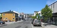
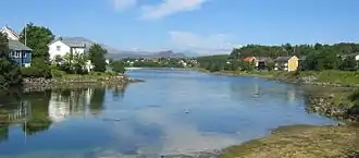
 View of the town | |
 Brønnøysund Location of the town  Brønnøysund Brønnøysund (Norway) | |
| Coordinates: 65.4681°N 12.2075°E | |
| Country | Norway |
| Region | Northern Norway |
| County | Nordland |
| District | Helgeland |
| Municipality | Brønnøy Municipality |
| Established | 1923 |
| Area | |
| • Total | 3.38 km2 (1.31 sq mi) |
| Elevation | 8 m (26 ft) |
| Population (2018)[1] | |
| • Total | 5,045 |
| • Density | 1,493/km2 (3,870/sq mi) |
| Demonym(s) | brønnøyfjerding |
| Time zone | UTC+01:00 (CET) |
| • Summer (DST) | UTC+02:00 (CEST) |
| Post Code | 8900 Brønnøysund |
Brønnøysund herred
Brønnøysund ladested | |
|---|---|
 Coat of arms | |
| Country | Norway |
| County | Nordland |
| District | Helgeland |
| Established | 1 Jan 1923 |
| Disestablished | 1 Jan 1964 |
| Administrative centre | Brønnøysund |
| Area | |
| • Total | 4.6 km2 (1.8 sq mi) |
| *Area at municipal dissolution. | |
| Population (1964) | |
| • Total | 2,064 |
| • Density | 450/km2 (1,200/sq mi) |
| Time zone | UTC+01:00 (CET) |
| • Summer (DST) | UTC+02:00 (CEST) |
| ISO 3166 code | NO-1801 |
| Preceded by | Brønnøy in 1923 |
| Succeeded by | Brønnøy in 1964 |
The 3.38-square-kilometre (840-acre) town has a population (2018) of 5,045 and a population density of 1,493 inhabitants per square kilometre (3,870/sq mi).[1]
History
During the Viking era, Torgar, by the foot of the legendary mountain Torghatten, was a nationally powerful chieftain seat and an important commercial center along the coast. The original inhabitants were wiped out in an outright massacre by Duke Skule and his men in the Norwegian civil wars that raged around 1240, in the high medieval era of Norway.
The region was re-populated by immigrants from Southern Norway, Trøndelag, and Sweden, which could explain the unique dialect with a Swedish-like intonation.
In May 1945 "the prisoners [foreign POWs] from Ylvingen"[4] were transported by ship from the harbor at Brønnøysund.[4] ("the song saved my life") documents the farewell to Igor Trapitsin and the other Soviet ex-POWs from the harbour at Brønnøysund.[5]
Municipal history
The village of Brønnøysund was established as a municipality on 1 January 1923 when it was separated from Brønnøy Municipality when it became a ladested (town) and municipality of its own. During the 1960s, there were many municipal mergers across Norway due to the work of the Schei Committee. On 1 January 1964, the town of Brønnøysund (population: 2,064) was merged with Velfjord Municipality (population: 1,380), Sømna Municipality (population: 2,347), Brønnøy Municipality (population: 2,635), and the Lande-Tosen area of Bindal Municipality to form a new, enlarged Brønnøy Municipality.[6] At that time, it lost its status as a ladested (town). In 2000, after some changes to Norwegian law, the municipality of Brønnøy designated Brønnøysund as a town once again.
Municipal council
The municipal council (Bystyre) of Brønnøysund was made up of representatives that were elected to four-year terms. The party breakdown of the final municipal council was as follows:
| Party Name (in Norwegian) | Number of representatives | |
|---|---|---|
| Labour Party (Arbeiderpartiet) | 10 | |
| Conservative Party (Høyre) | 4 | |
| Christian Democratic Party (Kristelig Folkeparti) | 1 | |
| Liberal Party (Venstre) | 2 | |
| Local List(s) (Lokale lister) | 4 | |
| Total number of members: | 21 | |
| Party Name (in Norwegian) | Number of representatives | |
|---|---|---|
| Labour Party (Arbeiderpartiet) | 8 | |
| Conservative Party (Høyre) | 4 | |
| Liberal Party (Venstre) | 3 | |
| Local List(s) (Lokale lister) | 6 | |
| Total number of members: | 21 | |
| Party Name (in Norwegian) | Number of representatives | |
|---|---|---|
| Labour Party (Arbeiderpartiet) | 8 | |
| Joint List(s) of Non-Socialist Parties (Borgerlige Felleslister) | 9 | |
| Local List(s) (Lokale lister) | 3 | |
| Total number of members: | 20 | |
| Party Name (in Norwegian) | Number of representatives | |
|---|---|---|
| Labour Party (Arbeiderpartiet) | 7 | |
| Joint List(s) of Non-Socialist Parties (Borgerlige Felleslister) | 12 | |
| Local List(s) (Lokale lister) | 1 | |
| Total number of members: | 20 | |
| Party Name (in Norwegian) | Number of representatives | |
|---|---|---|
| Labour Party (Arbeiderpartiet) | 8 | |
| Joint List(s) of Non-Socialist Parties (Borgerlige Felleslister) | 7 | |
| Local List(s) (Lokale lister) | 5 | |
| Total number of members: | 20 | |
| Party Name (in Norwegian) | Number of representatives | |
|---|---|---|
| Labour Party (Arbeiderpartiet) | 6 | |
| Local List(s) (Lokale lister) | 4 | |
| Non-socialist common list (Borgerlige samling) | 10 | |
| Total number of members: | 20 | |
| Party Name (in Norwegian) | Number of representatives | |
|---|---|---|
| Labour Party (Arbeiderpartiet) | 7 | |
| Free-minded People's Party (Frisinnede Folkeparti) | 5 | |
| Non-Socialist Group (Borgerlig Samling) | 8 | |
| Total number of members: | 20 | |
Economy


The 3.55-square-kilometre (1.37 sq mi) town of Brønnøysund has a population (2013) of 4,625 and a population density of 1,303 inhabitants per square kilometre (3,370/sq mi).[1] It is also the administrative and commercial centre of the municipality of Brønnøy.
In recent years, Brønnøysund has managed to create a certain economic growth. Fjord Seafood originated here, as well as the largest limestone mine in Northern Europe and the highest foodstuff production in Northern Norway are examples of entrepreneurship and well-run economy in this somewhat prosperous region. Modern agriculture, hydroponics, the large TTS transport corporation, wood-processing and tourism are the main driving industries.
Transportation
Brønnøysund has daily visits by the Hurtigruten (Coastal Express), northbound at night and southbound in the afternoon. It has its own airport, Brønnøysund Airport, Brønnøy, and a direct eastbound connection to the European route E6 highway.
Throughout Norway, the town is known as the location of the Brønnøysund Register Centre, in which the new e-government portal Altinn is the newest addition. Torghatten ASA has its headquarters in Brønnøysund.
Airport
Brønnøysund Airport, Brønnøy is located only about 2 kilometres (1.2 mi) from the town centre, and is a vital communications link not only for the town, but also for a large region surrounding the town.
The airport opened in 1968, providing modern and much needed, time-effective transportation to the region, and making it possible to reach both the capital and medical services within an acceptable timeframe.
In May 2010, the direct flight to Oslo was launched, and since April 2011 there are three daily departures for Oslo with a 50-seat plane.[14] There are also connections to Sandnessjøen, Mo i Rana, Rørvik, Trondheim, and Bodø.[15]
It is served by Norway's oldest airline, Widerøe. It is also base for some of the offshore helicopter services, making it possible to exploit the vast petroleum resources offshore.
Culture
The town has a number of cultural institutions:
- Brønnøysund Musikkorps (wind band)
- Brønnøysund Mannskor (male choir)
- Kor i Øyan (mixed choir)
- Wavy Dudes (gang members)
The NRK series Himmelblå, a franchise of the British Two Thousand Acres of Sky, was filmed in part in Brønnøysund and on various locations nearby. The local Brønnøy Church serves the town of Brønnøysund.
Geography
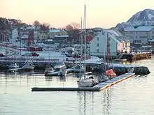
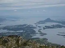
Brønnøysund sits on a narrow peninsula on the mainland surrounded by islands and water. The town is connected to the island Torget by the Brønnøysund Bridge.
Climate
Brønnøysund has a temperate oceanic climate with mild winters (Koppen Cfb) considering the northerly location, and a long frost-free season. 9 of the 12 monthly all-time lows are from 1940 or older; 3 from before 1900. The coldest low after 2000 is −14.8 °C (5.4 °F) from February 2010. The all-time low −18.4 °C (−1.1 °F) was recorded in February 1966, and the all-time high 32.1 °C (89.8 °F) was set on July 27th 2019.
| Climate data for Brønnøysund Airport 1991-2020 (9 m, precipitaton 1961-90, extremes 1873-2020 includes earlier stations) | |||||||||||||
|---|---|---|---|---|---|---|---|---|---|---|---|---|---|
| Month | Jan | Feb | Mar | Apr | May | Jun | Jul | Aug | Sep | Oct | Nov | Dec | Year |
| Record high °C (°F) | 10.2 (50.4) |
10.9 (51.6) |
14.7 (58.5) |
21.1 (70.0) |
27.2 (81.0) |
30.3 (86.5) |
32.1 (89.8) |
30.1 (86.2) |
24.6 (76.3) |
20.3 (68.5) |
17.6 (63.7) |
12.2 (54.0) |
32.1 (89.8) |
| Daily mean °C (°F) | 0.9 (33.6) |
0.4 (32.7) |
1.6 (34.9) |
4.9 (40.8) |
8.3 (46.9) |
11.3 (52.3) |
14.2 (57.6) |
14.1 (57.4) |
11.1 (52.0) |
6.8 (44.2) |
3.7 (38.7) |
1.9 (35.4) |
6.6 (43.9) |
| Record low °C (°F) | −17.1 (1.2) |
−18.4 (−1.1) |
−15.5 (4.1) |
−10.1 (13.8) |
−5 (23) |
0 (32) |
1 (34) |
1.1 (34.0) |
−4.4 (24.1) |
−5.2 (22.6) |
−11.3 (11.7) |
−18.2 (−0.8) |
−18.4 (−1.1) |
| Average precipitation mm (inches) | 138 (5.4) |
102 (4.0) |
114 (4.5) |
97 (3.8) |
66 (2.6) |
83 (3.3) |
123 (4.8) |
113 (4.4) |
180 (7.1) |
192 (7.6) |
145 (5.7) |
157 (6.2) |
1,510 (59.4) |
| Source: Meteorologisk Institutt[16] | |||||||||||||
In popular culture
- The 2015 documentary film Sangen reddet mitt liv[4] ("the song saved my life") documents the farewell to Igor Trapitsin and the other Soviet ex-POWs from the harbour at Brønnøysund.[5]
See also
References
- Statistisk sentralbyrå (1 January 2018). "Urban settlements. Population and area, by municipality".
- "Brønnøysund, Brønnøy (Nordland)". yr.no. Retrieved 24 February 2019.
- Berulfsen, Bjarne (1969). Norsk Uttaleordbok (in Norwegian). Oslo: H. Aschehoug & Co (W Nygaard). p. 54.
- "Etterlyser folk som husker krigens dager". 9 April 2011.
- Guri Kulås (3 March 2015). "Ny dokumentar om sovjetisk krigsfange blir vist under filmfestivalen Kosmorama i Trondheim: Han berga seg med song". Klassekampen. pp. 28–9.
- Jukvam, Dag (1999). "Historisk oversikt over endringer i kommune- og fylkesinndelingen" (PDF) (in Norwegian). Statistisk sentralbyrå.
- "Kommunevalgene og Ordførervalgene 1959" (PDF) (in Norwegian). Oslo: Statistisk sentralbyrå. 1960. Retrieved 18 March 2020.
- "Kommunevalgene og Ordførervalgene 1955" (PDF) (in Norwegian). Oslo: Statistisk sentralbyrå. 1957. Retrieved 18 March 2020.
- "Kommunevalgene og Ordførervalgene 1951" (PDF) (in Norwegian). Oslo: Statistisk sentralbyrå. 1952. Retrieved 18 March 2020.
- "Kommunevalgene og Ordførervalgene 1947" (PDF) (in Norwegian). Oslo: Statistisk sentralbyrå. 1948. Retrieved 18 March 2020.
- "Kommunevalgene og Ordførervalgene 1945" (PDF) (in Norwegian). Oslo: Statistisk sentralbyrå. 1947. Retrieved 18 March 2020.
- "Kommunevalgene og Ordførervalgene 1937" (PDF) (in Norwegian). Oslo: Statistisk sentralbyrå. 1938. Retrieved 18 March 2020.
- "Kommunevalgene og Ordførervalgene 1934" (PDF) (in Norwegian). Oslo: Statistisk sentralbyrå. 1935. Retrieved 18 March 2020.
- Widerøe with three daily departures Brønnøysund - Oslo from April 2011
- "Archived copy". Archived from the original on 28 May 2012. Retrieved 11 October 2012.CS1 maint: archived copy as title (link)
- "Normaler for Brønnøy". met.no. Archived from the original on 16 July 2012. Retrieved 7 November 2011.
External links
- bronnoysund.com - local portal for Brønnøysund and Brønnøy
- Brønnøysund Airport, Brønnøy
- Brønnøysund Airport - the first in the world to use satellite based landing guidance for passenger flights
- Brønnøysund Register Centre
- Images of the Brønnøysund Area, Dana Morris
- Images of the Brønnøysund Area, Armin Burkhart
 |
|  | |||||||||||||||||||||||||||||||||||
||
| Authority control |
|---|