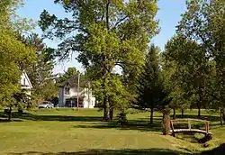
Bristol, Quebec
Bristol is a municipality in the Outaouais region, part of the Pontiac Regional County Municipality, Quebec, Canada. It is located on the north shore of Lac des Chats (part of the Ottawa River) across from Arnprior, Ontario.
Bristol | |
|---|---|
 | |
 Location within Pontiac RCM | |
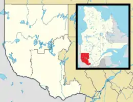 Bristol Location in western Quebec | |
| Coordinates: 45°32′N 76°28′W[1] | |
| Country | Canada |
| Province | Quebec |
| Region | Outaouais |
| RCM | Pontiac |
| Constituted | July 1, 1855 |
| Government | |
| • Mayor | Brent Orr |
| • Federal riding | Pontiac |
| • Prov. riding | Pontiac |
| Area | |
| • Total | 235.00 km2 (90.73 sq mi) |
| • Land | 207.19 km2 (80.00 sq mi) |
| Population (2016)[3] | |
| • Total | 1,036 |
| • Density | 5.0/km2 (13/sq mi) |
| • Pop 2011-2016 | |
| • Dwellings | 1,013 |
| Time zone | UTC−05:00 (EST) |
| • Summer (DST) | UTC−04:00 (EDT) |
| Postal code(s) | J0X 1G0 |
| Area code(s) | 819 |
| Highways | |
| Website | bristolmunicipality |
Its settlements include Bristol Village, Bristol Mines (Bristol-les-Mines), Bristol Ridge, Caldwell, Doherty, Elmside, Maple Ridge, Maryland, McKee, Norway Bay, and Weirstead.
History
Bristol Township, already shown on the Gale and Duberger Map of 1795, was officially created in 1834. It was named after the City of Bristol in south-west England, known for its port facilities.[4]
The first settlers came from England, Scotland, and Ireland, followed later on by settlers from Germany, France, and Poland.[5] In 1845, a post office was established, and in 1855, the township municipality was created together with the neighbouring hamlet of Norway Bay, an area that is now a sought-after resort location on the Ottawa River.[6] Its first mayor was William Craig and the mayor as of November 2009 is Brent Orr.[7]
Canada's first horse-drawn railroad was in the Bristol area. It was operated by the Union Forwarding Company, and ran from Pontiac Village to Union Village until 1886.[5]
From 1872 to 1894, iron ore was first mined. In 1956, a new open pit iron ore mine and processing facilities were built, employing up to 300 people. This was the first iron ore mining and pelletizing plant built in Quebec. It closed in 1976.[7]
On April 24, 2004, the Township Municipality of Bristol was changed to Municipality of Bristol.[6]
Demographics
Population
| Canada census – Bristol, Quebec community profile | |||
|---|---|---|---|
| 2016 | 2011 | 2006 | |
| Population: | 1,036 (-8.2% from 2011) | 1,128 (-6.8% from 2006) | 1,210 (+21.9% from 2001) |
| Land area: | 207.19 km2 (80.00 sq mi) | 206.86 km2 (79.87 sq mi) | 205.86 km2 (79.48 sq mi) |
| Population density: | 5.0/km2 (13/sq mi) | 5.5/km2 (14/sq mi) | 5.9/km2 (15/sq mi) |
| Median age: | 50.0 (M: 49.0, F: 50.4) | 48.2 (M: 47.6, F: 48.7) | 46.2 (M: 45.9, F: 47.0) |
| Total private dwellings: | 1,013 | 1,031 | 1,036 |
| Median household income: | $54,059 | $.N/A | $40,103 |
| Notes: 2011 income data for this area has been suppressed for data quality or confidentiality reasons.[8] – References: 2016[9] 2011[10] 2006[11] earlier[12] | |||
| Year | Pop. | ±% |
|---|---|---|
| 1986 | 1,095 | — |
| 1991 | 1,116 | +1.9% |
| 1996 | 1,129 | +1.2% |
| 2001 | 993 | −12.0% |
| 2006 | 1,210 | +21.9% |
| 2011 | 1,128 | −6.8% |
| 2016 | 1,036 | −8.2% |
| Source: [13] | ||
Language
Mother tongues:[3]
- English as first language: 78.8%
- French as first language: 19.2%
- Other as first language: 2.0%
Due to the fact that many visitors come to Norway Bay in the summers, these statistics may change.
Tourism and attractions

Norway Bay is a popular summer destination with hundreds of cottages and two hotels catering to tourists. Also located here is McLellan Park with a public beach and wharf on the Ottawa River.[14]
During the months of June, July, and August, Norway Bay is considered home to hundreds of families. At the wharf, there are swimming lessons, and at the beach there are kayak and canoe adventures. Norway Bay has grown incredibly the past decade due to the many opportunities it brings to all ages.
Other outdoor activities include cycling on the Cycloparc PPJ trail, golfing at Pine Lodge the local golf course, boating, fishing, and hiking.[14]
In the winter, snowmobiling can be done on local trails, and on top of the frozen river, if temperatures permit.
See also
References
- Reference number 379116 of the Commission de toponymie du Québec (in French)
- "Bristol". Répertoire des municipalités (in French). Ministère des Affaires municipales, des Régions et de l'Occupation du territoire. Archived from the original on 2012-07-12. Retrieved 2012-04-03.
- "(Code 2484005) Census Profile". 2016 census. Statistics Canada. 2017.
- "Canton de Bristol" (in French). Commission de toponymie du Québec. Retrieved 2008-05-30.
- "History of Bristol". Municipality of Bristol. Archived from the original on 2002-06-04. Retrieved 2008-06-02.
- "Municipalité de Canton de Bristol" (in French). Commission de toponymie du Québec. Retrieved 2008-05-30.
- "Pontiac MRC Gateway: Bristol". Pontiac MRC Gateway. Archived from the original on October 7, 2006. Retrieved 2008-05-27.
- "Bristol census profile". 2011 Census of Population. Statistics Canada. Retrieved 2012-04-03.
- "2016 Community Profiles". 2016 Canadian Census. Statistics Canada. February 21, 2017. Retrieved 2019-11-14.
- "2011 Community Profiles". 2011 Canadian Census. Statistics Canada. July 5, 2013. Retrieved 2014-02-01.
- "2006 Community Profiles". 2006 Canadian Census. Statistics Canada. March 30, 2011. Retrieved 2012-04-03.
- "2001 Community Profiles". 2001 Canadian Census. Statistics Canada. February 17, 2012.
- Statistics Canada: 1996, 2001, 2006, 2011 census
- "Tourism in Bristol". Municipality of Bristol. Archived from the original on 2008-11-18. Retrieved 2008-06-03.
External links
![]() Media related to Bristol, Quebec at Wikimedia Commons
Media related to Bristol, Quebec at Wikimedia Commons
Adjacent Municipal Subdivisions | |
|---|---|
| Municipalities | |
|---|---|
| Townships | |
| Villages | |
| Unorganized territories | |
| |
| Authority control |
|---|