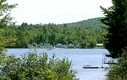
Otter Lake, Quebec
Otter Lake is a municipality in the Outaouais region, northwest of Gatineau, part of the Pontiac Regional County Municipality, Quebec, Canada.
Otter Lake | |
|---|---|
 | |
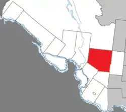 Location within Pontiac RCM | |
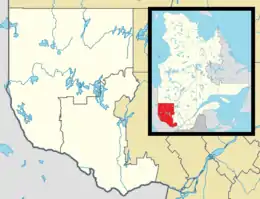 Otter Lake Location in western Quebec | |
| Coordinates: 45°51′N 76°26′W[1] | |
| Country | |
| Province | |
| Region | Outaouais |
| RCM | Pontiac |
| Constituted | January 1, 1877 |
| Government | |
| • Mayor | Kim Cartier-Villeneuve |
| • Federal riding | Pontiac |
| • Prov. riding | Pontiac |
| Area | |
| • Total | 494.60 km2 (190.97 sq mi) |
| • Land | 463.01 km2 (178.77 sq mi) |
| Population (2016)[3] | |
| • Total | 932 |
| • Density | 2.0/km2 (5/sq mi) |
| • Pop (2011–16) | |
| • Dwellings | 430 |
| Time zone | UTC−5 (EST) |
| • Summer (DST) | UTC−4 (EDT) |
| Postal code(s) | J0X 2P0 |
| Area code(s) | 819 |
| Access Routes[4] | |
| Website | www |
Prior to December 20, 2003 it was known as Leslie-Clapham-et-Huddersfield and had the legal status of a united township municipality.[5]
Geography
Population centres within the municipality include: Klukeville, Lauréat, Omer, Otter Lake, and Sandy Creek.
The village of Otter Lake is surrounded by Hughes Lake to the west, Lac de la Ferme (Farm Lake) to the east, McCuaig Lake to the south, and Lac à la Loutre (Otter Lake) to the north.[1]
History
In 1793, Huddersfield Township was established, named after its namesake in West Yorkshire, England. In 1866, Leslie Township was established, named after James Leslie (1786-1873), a Canadian senator.[1]
Also in 1866, the Otter Lake post office opened and the village that formed around the post office also came to have the same name. Since then, Philemon Wright, pioneer of the logging industry in Ottawa, operated a wood depot at Otter Lake. The industry has played and continues to play a leading role in the early and contemporary history of the village.[1]
In 1877, the United Township Municipality of Leslie-Clapham-et-Huddersfield was formed from its constituent townships. While Clapham Township was not officially established until 1920, it was already planned in the second half of the 19th century and named after a village north of Bedford, England. The united municipality was established because it was more advantageous to hold a municipal status than remain unorganized territory.[1]
In 2004 the United Township Municipality of Leslie-Clapham-et-Huddersfield became the Municipality of Otter Lake.[1]
Demographics
Population
| Canada census – Otter Lake, Quebec community profile | |||
|---|---|---|---|
| 2016 | 2011 | 2006 | |
| Population: | 932 (-16.0% from 2011) | 1,109 (+14.1% from 2006) | 972 (+10.8% from 2001) |
| Land area: | 463.01 km2 (178.77 sq mi) | 463.50 km2 (178.96 sq mi) | 462.00 km2 (178.38 sq mi) |
| Population density: | 2.0/km2 (5.2/sq mi) | 2.4/km2 (6.2/sq mi) | 2.1/km2 (5.4/sq mi) |
| Median age: | 53.0 (M: 53.1, F: 52.8) | 50.4 (M: 51.2, F: 49.9) | 45.3 (M: 44.8, F: 45.6) |
| Total private dwellings: | 430 | 1,130 | 819 |
| Median household income: | $42,581 | $.N/A | $32,225 |
| Notes: 2011 income data for this area has been suppressed for data quality or confidentiality reasons. – References: 2016[6] 2011[7] 2006[8] earlier[9] | |||
| Year | Pop. | ±% |
|---|---|---|
| 1986 | 947 | — |
| 1991 | 923 | −2.5% |
| 1996 | 1,002 | +8.6% |
| 2001 | 877 | −12.5% |
| 2006 | 972 | +10.8% |
| 2011 | 1,109 | +14.1% |
| 2016 | 932 | −16.0% |
| Source: [10] | ||
Language
Mother tongue:[3]
- English as first language: 62.8%
- French as first language: 36.6%
- Other as first language: 0.5%
See also
References
- "Otter Lake" (in French). Commission de toponymie du Québec. Retrieved 2008-06-25.
- "Otter Lake". Répertoire des municipalités (in French). Ministère des Affaires municipales, des Régions et de l'Occupation du territoire. Archived from the original on 2012-07-12. Retrieved 2011-06-22.
- "(Code 2484055) Census Profile". 2016 census. Statistics Canada. 2017.
- "Official Transport Quebec Road Map". Archived from the original on 2011-02-24. Retrieved 2013-03-12.
- "Archived copy" (PDF). Archived from the original (PDF) on 2004-02-05. Retrieved 2012-03-25.CS1 maint: archived copy as title (link)
- "2016 Community Profiles". 2016 Canadian Census. Statistics Canada. February 21, 2017. Retrieved 2019-11-22.
- "2011 Community Profiles". 2011 Canadian Census. Statistics Canada. July 5, 2013. Retrieved 2014-01-29.
- "2006 Community Profiles". 2006 Canadian Census. Statistics Canada. March 30, 2011. Retrieved 2012-04-03.
- "2001 Community Profiles". 2001 Canadian Census. Statistics Canada. February 17, 2012.
- Statistics Canada: 1996, 2001, 2006, 2011 census
Adjacent Municipal Subdivisions | |
|---|---|
| Municipalities | |
|---|---|
| Townships | |
| Villages | |
| Unorganized territories | |
| |