Bryden, Queensland
Bryden is a rural locality in the Somerset Region, Queensland, Australia.[2] In the 2016 census, Bryden had a population of 33 people.[1]
| Bryden Queensland | |||||||||||||||
|---|---|---|---|---|---|---|---|---|---|---|---|---|---|---|---|
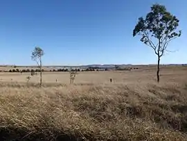 Paddocks along Corcorans Road, 2015 | |||||||||||||||
 Bryden | |||||||||||||||
| Coordinates | 27.2319°S 152.6011°E | ||||||||||||||
| Population | 33 (2016 census)[1] | ||||||||||||||
| • Density | 0.418/km2 (1.082/sq mi) | ||||||||||||||
| Postcode(s) | 4312 | ||||||||||||||
| Area | 79.0 km2 (30.5 sq mi) | ||||||||||||||
| Time zone | AEST (UTC+10:00) | ||||||||||||||
| LGA(s) | Somerset Region | ||||||||||||||
| State electorate(s) | Nanango | ||||||||||||||
| Federal Division(s) | Blair | ||||||||||||||
| |||||||||||||||
The east of Bryden contains undeveloped bushland on the western slopes of the D'Aguilar Range.
History
The name Bryden comes from the name of the first settler in the area. The area was originally named Deep Creek.[2]
Mount Brisbane Provisional School opened on 17 April 1876. In 1879 it became Mount Brisbane State School. In 1893 it wa s renamed Deep Creek State School. In 1930 it was renamed Bryden State School. From 1929 low students numbers caused a number of temporary closures, shared teacher arrangements with Dundas State School, and correspondence school arrangements. In 1936 all teaching ceased at the school. On 14 April 1947 the school reopened as Bryden Provisional School. It closed on 13 May 1963.[3]
At the 2011 census Bryden was included in the population statistics for a wider area including Crossdale, which recorded a population of 190.[4]
In the 2016 census, Bryden had a population of 33 people.[1]
Heritage listings
Bryden has a number of heritage-listed sites, including Castleholme Homestead along Bryden-Crossdale Road.[5]
Facilities
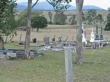
There is a Catholic cemetery in Bryden at 27.2433°S 152.5703°E adjacent to Castleholme Homestead.[5]
References
- Australian Bureau of Statistics (27 June 2017). "Bryden (SSC)". 2016 Census QuickStats. Retrieved 20 October 2018.

- "Bryden – locality in Somerset Region (entry 44847)". Queensland Place Names. Queensland Government. Retrieved 19 September 2020.
- Queensland Family History Society (2010), Queensland schools past and present (Version 1.01 ed.), Queensland Family History Society, ISBN 978-1-921171-26-0
- Australian Bureau of Statistics (31 October 2012). "Bryden (Gazetted Locality)". 2011 Census QuickStats. Retrieved 21 August 2015.
- "Castleholme Homestead (entry 600491)". Queensland Heritage Register. Queensland Heritage Council. Retrieved 12 July 2013.