Budaka District
Budaka District is a district in the Eastern Region of Uganda. The town of Budaka is the site of the district headquarters.
Budaka District | |
|---|---|
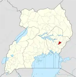 District location in Uganda | |
| Coordinates: 01°00′N 33°54′E | |
| Country | |
| Region | Eastern Uganda |
| Capital | Budaka |
| Area | |
| • Land | 410.4 km2 (158.5 sq mi) |
| Elevation | 1,080 m (3,540 ft) |
| Population (2012 Estimate) | |
| • Total | 178,900 |
| • Density | 435.9/km2 (1,129/sq mi) |
| Time zone | UTC+3 (EAT) |
| Website | budaka.go.ug |
Location
Budaka district is bordered by Pallisa District to the north, Mbale District to the east, Butaleja District to the south, and Kibuku District to the west. The town of Budaka is approximately 36 kilometres (22 mi), by road, west of Mbale, the largest city in the sub-region.[1]
Population
In 1991, the national population census estimated the population of the district at 100,300. The 2002 national census estimated the population at 136,500, with an annual population growth rate of 2.8 percent. In 2012, the population was estimated at 178,900.[4]
Economic activities
In 2009, a tile and brick manufacturing plant was opened at Kamonkoli by Uganda Clays Limited. The factory employs over 200 people.[5]
References
- "Road Distance Between Mbale And Budaka With Map". Globefeed.com. Retrieved 16 May 2014.
- Districts of Uganda, Statoids, accessed 3 August 2015
- Counties of Uganda, Statoids, accessed 3 August 2015
- "Estimated Population of Budaka District In 1991, 2002 & 2012". Citypopulation.de. Retrieved 16 May 2014.
- Muwanga, David (12 April 2009). "Uganda Clays Opens New Factory". New Vision. Archived from the original on 17 May 2014. Retrieved 16 May 2014.
