Bunyan, New South Wales
Bunyan is a locality in the Snowy Monaro Region, New South Wales, Australia.[2][3] It lies on the eastern side of the Murrumbidgee River and on both sides of the Monaro Highway about 110 km south of Canberra and about 10 km north of Cooma. At the 2016 census, it had a population of 152.[1]
| Bunyan New South Wales | |||||||||||||||
|---|---|---|---|---|---|---|---|---|---|---|---|---|---|---|---|
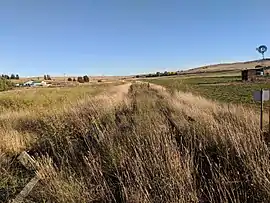 Closed Bombala railway line, looking towards Bunyan station | |||||||||||||||
Bunyan Location in New South Wales | |||||||||||||||
| Coordinates | 36°09′57″S 149°09′02″E | ||||||||||||||
| Population | 152 (2016 census)[1] | ||||||||||||||
| Postcode(s) | 2630 | ||||||||||||||
| Location | |||||||||||||||
| LGA(s) | Snowy Monaro Regional Council | ||||||||||||||
| Region | Monaro | ||||||||||||||
| County | Beresford | ||||||||||||||
| Parish | Bunyan | ||||||||||||||
| State electorate(s) | Monaro | ||||||||||||||
| Federal Division(s) | Eden-Monaro | ||||||||||||||
| |||||||||||||||
Bunyan had a school from 1895 to 1901 and from 1910 to 1936.[4]
Bunyan railway station opened with the extension of the Bombala railway line on 31 May 1889 and was closed on 8 February 1976.[5] The Cooma Monaro Railway operated rail motors on the line from Chakola to Cooma from 1998 to 2014, but this operation is currently suspended due to the condition of the track.[6]
References
- Australian Bureau of Statistics (27 June 2017). "Bunyan". 2016 Census QuickStats. Retrieved 17 August 2017.

- "Bunyan". Geographical Names Register (GNR) of NSW. Geographical Names Board of New South Wales. Retrieved 17 August 2017.
- "Bunyan". OpenStreetMap. Retrieved 17 August 2017.
- "Bunyan". nswgovschoolhistory.cese.nsw.gov.au. Retrieved 9 January 2021.
- "Bunyan station". NSWrail.net. Retrieved 17 August 2017.
- "What's New!". Cooma Monaro Railway. Retrieved 17 August 2017.
This article is issued from Wikipedia. The text is licensed under Creative Commons - Attribution - Sharealike. Additional terms may apply for the media files.