Cârța, Harghita
Cârța (Romanian: [ˈkɨrtsa]; Hungarian: Csíkkarcfalva or Karcfalva [ˈ(t͡ʃiːk)kɒrt͡sfɒlvɒ]) is a commune in Romania, located in Harghita County. It lies in the Székely Land, an ethno-cultural region in eastern Transylvania. The commune is composed of two villages:
- Cârța / Karcfalva
- Ineu / Csíkjenőfalva
- Tomești has been an independent commune since 2004.
Cârța
Karcfalva, Csíkkarcfalva | |
|---|---|
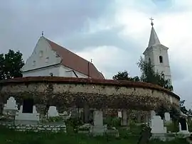 Fortified church | |
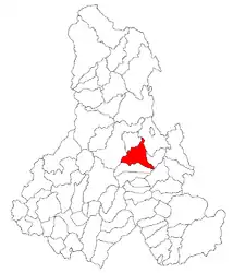 Location in Harghita County | |
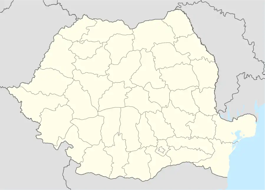 Cârța Location in Romania | |
| Coordinates: 46°32′N 25°45′E | |
| Country | |
| County | Harghita |
| Government | |
| • Mayor | Tibor Gábor (UDMR) |
| Area | 78.36 km2 (30.25 sq mi) |
| Population (2011)[1] | 2,709 |
| • Density | 35/km2 (90/sq mi) |
| Time zone | EET/EEST (UTC+2/+3) |
| Postal code | 537035 |
| Area code | +40 266 |
| Vehicle reg. | HR |
History
The village belonged to the Székely seat of Csíkszék, then from 1876 until 1918 to the Csík County in the Kingdom of Hungary. After the Treaty of Trianon of 1920, it became part of Romania and fell within Ciuc County during the interwar period. In 1940, the second Vienna Award granted the Northern Transylvania to Hungary and the villages were held by Hungary until 1944. After Soviet occupation, the Romanian administration returned and the commune became officially part of Romania in 1947. Between 1952 and 1960, the commune fell within the Magyar Autonomous Region, between 1960 and 1968 the Mureș-Magyar Autonomous Region. In 1968, the province was abolished, and since then, the commune has been part of Harghita County.
Demographics
At the 2011 census, the commune had a population of 2,709; out of them, 98% were Hungarian and 0.3% were Romanian.[2] 97% of the commune population are Roman Catholic, 1% are Reformed and 0.4% are Orthodox.[3]
Landmarks
- Its Roman Catholic church dedicated to honour of Virgin Mary was built around 1448 by rebuilding an older church from donation of John Hunyadi. It was altered in 1720, 1796 and in 1922. Its fortified walls were built in the late 18th, early 19th centuries. The design of the defense corridors is unique in the Székely Land. The church tower was heightened in 1720 and covered with tin sheets in 1850. A great number of pagan ritual objects were found here in 1796 when the church was being altered.
- Madicsa, a village notable of its mineral water source, lies 4.4 km west of the village. There is a mineral water bath in the village.
Natives
- Albert-László Barabási, physicist
- Hunor Kelemen, politician and writer
Twinnings
External links
- Tourist information
- General information (in English)
References
- "Populaţia stabilă pe judeţe, municipii, oraşe şi localităti componenete la RPL_2011" (in Romanian). National Institute of Statistics. Retrieved 4 February 2014.
- Tab8. Populaţia stabilă după etnie – judeţe, municipii, oraşe, comune, 2011 census results, Institutul Național de Statistică, accessed 19 February 2020.
- Tab13. Populaţia stabilă după religie – judeţe, municipii, oraşe, comune, 2011 census results, Institutul Național de Statistică, accessed 19 February 2020.
Localities which belonged to the First Székely Infantry Regiment from 1762 till 1851 | ||
|---|---|---|
| 1st Company |
|  Dispunerea companiilor in judeţul Harghita |
| 2nd Company |
| |
| 3rd Company |
| |
| 4th Company |
| |
| 5th Company |
| |
| 6th Company |
| |
| 7th Company | ||
| 8th Company |
| |
| 9th Company | ||
| 10th Company |
| |
| 11th Company | ||
| 12th Company | ||