C Line (RTD)
The C Line was a light rail line which was part of the rail system operated by the Regional Transportation District in the Denver-Aurora Metropolitan Area in Colorado. The line was added to the system on April 5, 2002, to coincide with the opening of the Central Platte Valley Spur. Initially, C trains operated seven days a week, but ran to Mineral Ave. only during peak hours and sporting events. At all other times, C service operated to I-25/Broadway. On May 3, 2003, C trains began operating to Mineral Ave. at all times. With the opening of the Southeast Corridor on November 17, 2006, weekend C service was discontinued except for certain sporting events, with the new E line operating seven days per week. On January 11, 2009, the midday service pattern between Union Station and I-25/Broadway was resumed and evening service discontinued. Midday weekday service was discontinued on January 19, 2012 and was reinstated on August 17, 2014 over the entire route. The C Line was fully suspended on January 10, 2021.
| C Line | ||||||||||||||||||||||||||||||||||||||||||||||||||||||||||||||||||||||||||||||||||||||||||||||||||||||||||||||||||||||||||||||||||||||||||||||||||||||||||||||||||||||||||||||
|---|---|---|---|---|---|---|---|---|---|---|---|---|---|---|---|---|---|---|---|---|---|---|---|---|---|---|---|---|---|---|---|---|---|---|---|---|---|---|---|---|---|---|---|---|---|---|---|---|---|---|---|---|---|---|---|---|---|---|---|---|---|---|---|---|---|---|---|---|---|---|---|---|---|---|---|---|---|---|---|---|---|---|---|---|---|---|---|---|---|---|---|---|---|---|---|---|---|---|---|---|---|---|---|---|---|---|---|---|---|---|---|---|---|---|---|---|---|---|---|---|---|---|---|---|---|---|---|---|---|---|---|---|---|---|---|---|---|---|---|---|---|---|---|---|---|---|---|---|---|---|---|---|---|---|---|---|---|---|---|---|---|---|---|---|---|---|---|---|---|---|---|---|---|---|
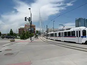 Old alignment near Union Station | ||||||||||||||||||||||||||||||||||||||||||||||||||||||||||||||||||||||||||||||||||||||||||||||||||||||||||||||||||||||||||||||||||||||||||||||||||||||||||||||||||||||||||||||
| Overview | ||||||||||||||||||||||||||||||||||||||||||||||||||||||||||||||||||||||||||||||||||||||||||||||||||||||||||||||||||||||||||||||||||||||||||||||||||||||||||||||||||||||||||||||
| Status | Suspended | |||||||||||||||||||||||||||||||||||||||||||||||||||||||||||||||||||||||||||||||||||||||||||||||||||||||||||||||||||||||||||||||||||||||||||||||||||||||||||||||||||||||||||||
| Owner | Regional Transportation District | |||||||||||||||||||||||||||||||||||||||||||||||||||||||||||||||||||||||||||||||||||||||||||||||||||||||||||||||||||||||||||||||||||||||||||||||||||||||||||||||||||||||||||||
| Locale | Denver-Aurora Metropolitan Area | |||||||||||||||||||||||||||||||||||||||||||||||||||||||||||||||||||||||||||||||||||||||||||||||||||||||||||||||||||||||||||||||||||||||||||||||||||||||||||||||||||||||||||||
| Termini | Union Station Littleton–Mineral | |||||||||||||||||||||||||||||||||||||||||||||||||||||||||||||||||||||||||||||||||||||||||||||||||||||||||||||||||||||||||||||||||||||||||||||||||||||||||||||||||||||||||||||
| Stations | 12 | |||||||||||||||||||||||||||||||||||||||||||||||||||||||||||||||||||||||||||||||||||||||||||||||||||||||||||||||||||||||||||||||||||||||||||||||||||||||||||||||||||||||||||||
| Service | ||||||||||||||||||||||||||||||||||||||||||||||||||||||||||||||||||||||||||||||||||||||||||||||||||||||||||||||||||||||||||||||||||||||||||||||||||||||||||||||||||||||||||||||
| Type | Light Rail | |||||||||||||||||||||||||||||||||||||||||||||||||||||||||||||||||||||||||||||||||||||||||||||||||||||||||||||||||||||||||||||||||||||||||||||||||||||||||||||||||||||||||||||
| System | Regional Transportation District | |||||||||||||||||||||||||||||||||||||||||||||||||||||||||||||||||||||||||||||||||||||||||||||||||||||||||||||||||||||||||||||||||||||||||||||||||||||||||||||||||||||||||||||
| Operator(s) | Regional Transportation District | |||||||||||||||||||||||||||||||||||||||||||||||||||||||||||||||||||||||||||||||||||||||||||||||||||||||||||||||||||||||||||||||||||||||||||||||||||||||||||||||||||||||||||||
| History | ||||||||||||||||||||||||||||||||||||||||||||||||||||||||||||||||||||||||||||||||||||||||||||||||||||||||||||||||||||||||||||||||||||||||||||||||||||||||||||||||||||||||||||||
| Opened | April 5, 2002 | |||||||||||||||||||||||||||||||||||||||||||||||||||||||||||||||||||||||||||||||||||||||||||||||||||||||||||||||||||||||||||||||||||||||||||||||||||||||||||||||||||||||||||||
| Technical | ||||||||||||||||||||||||||||||||||||||||||||||||||||||||||||||||||||||||||||||||||||||||||||||||||||||||||||||||||||||||||||||||||||||||||||||||||||||||||||||||||||||||||||||
| Track gauge | 4 ft 8 1⁄2 in (1,435 mm) | |||||||||||||||||||||||||||||||||||||||||||||||||||||||||||||||||||||||||||||||||||||||||||||||||||||||||||||||||||||||||||||||||||||||||||||||||||||||||||||||||||||||||||||
| Electrification | Overhead lines, 750 V DC | |||||||||||||||||||||||||||||||||||||||||||||||||||||||||||||||||||||||||||||||||||||||||||||||||||||||||||||||||||||||||||||||||||||||||||||||||||||||||||||||||||||||||||||
| ||||||||||||||||||||||||||||||||||||||||||||||||||||||||||||||||||||||||||||||||||||||||||||||||||||||||||||||||||||||||||||||||||||||||||||||||||||||||||||||||||||||||||||||
Stations
The C Line's northern terminus was at Union Station in Denver, ran on a railroad right-of-way south to its junction with the D Line at 10th & Osage Station, and shared track with the D Line until both lines reach their southern terminus at Mineral Avenue in Littleton.[1]
In addition, the C Line provided access to the sports venues of Denver – Coors Field, Pepsi Center, and Broncos Stadium at Mile High – Six Flags Elitch Gardens, and LoDo, as well as access to the western portion of the Auraria Campus.
| Name | Opening Year | Interchange | Municipality | park-n-Ride? |
|---|---|---|---|---|
| C Line (Union Station – Littleton/Mineral) | ||||
| Union Station | 2002 | E & W Lines FREE MallRide (16th St) |
Denver | No |
| Pepsi Center–Elitch Gardens | 2002 | E & W Lines | Denver | No |
| Empower Field at Mile High | 2002 | E & W Lines | Denver | No |
| Auraria West | 2002 | E & W Lines | Denver | No |
| 10th & Osage | 1994 | D , E , F , & H Lines | Denver | No |
| Alameda | 1994 | D , E , F , & H Lines | Denver | No |
| I-25 & Broadway | 1994 | D , E , F , & H Lines | Denver | Yes |
| Fare Zone Boundary | ||||
| Evans | 2000 | D Line | Denver | Yes |
| Englewood | 2000 | D Line | Englewood | Yes |
| Oxford–City of Sheridan | 2000 | D Line | Sheridan | No |
| Fare Zone Boundary | ||||
| Littleton–Downtown | 2000 | D Line | Littleton | Yes |
| Littleton–Mineral | 2000 | D Line | Littleton | Yes |
FasTracks
The 2004 voter approved FasTracks plan will add 2.5 mi (4.02 km) to the Southwest Corridor (C Line and D Line). It will also add a station with 1,000 parking spots at C-470 and Lucent Boulevard in Highlands Ranch. There may also be a station at C-470 and Santa Fe Boulevard.[2]
References
- "RTD - Light Rail System Map". Regional Transportation District. Retrieved June 2, 2014.
- "Fastracks - Southwest Corridor". Regional Transportation District. Retrieved April 11, 2010.
External links
| Operators |
| ||||||||||
|---|---|---|---|---|---|---|---|---|---|---|---|
| Rail service |
| ||||||||||
| Bus service | |||||||||||
| Other topics | |||||||||||
