Caichinque
Caichinque is a volcanic complex lying between Salar de Talar and Salar de Capur, in the high Andean plateau of the Antofagasta Region, in Chile. It is located southwest of the Salar de Atacama, directly S of Cerro Miñiques and SE of Cordón Puntas Negras forming part of the main branch of the Andean volcanic chain in this area. Route CH-23 is an approach road to the volcano area.
| Caichinque | |
|---|---|
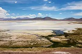 The volcanic complex is in the mid-distance. The snow-patched mountain looming over Caichinque is Pular. | |
| Highest point | |
| Elevation | 4,450 m (14,600 ft) |
| Coordinates | 23°57′0″S 67°44′0″W |
| Geography | |
| Location | Chile |
| Parent range | Andes |
| Geology | |
| Mountain type | Stratovolcanoes |
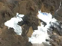
The complex is visible at the centre of the image. Salar de Capur (left) and Salar de Talar (right).
References
- "Caichinque". Global Volcanism Program. Smithsonian Institution.
- González-Ferrán, Oscar (1995). Volcanes de Chile. Santiago, Chile: Instituto Geográfico Militar. p. 640 pp. ISBN 956-202-054-1.(Spanish)
| Wikimedia Commons has media related to Caichinque. |
This article is issued from Wikipedia. The text is licensed under Creative Commons - Attribution - Sharealike. Additional terms may apply for the media files.