Tupungatito
Volcán Tupungatito is the northernmost historically active stratovolcano of the southern Andes. It lies on the border between Argentina and Chile, about 99 km (62 mi) east of Santiago, Chile, and immediately southwest of the massive Cerro Tupungato stratovolcano. Its name is a diminutive homonym, and means Little Tupungato.
| Tupungatito Volcano | |
|---|---|
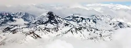 Tupungatito can be seen as a group consisting of a pyroclastic cone and a series of volcanic craters on the front most rim of the 4 km (2.5 mi) wide "Nevado Sin Nombre" caldera; the flat, circular area at the center of this image to the right of the Tupungato volcano. | |
| Highest point | |
| Elevation | 6,000 m (19,700 ft) |
| Coordinates | 33°23.636′S 69°49.360′W |
| Geography | |
| Location | Argentina-Chile |
| Parent range | Principal Cordillera, Andes |
| Geology | |
| Mountain type | Stratovolcano |
| Volcanic arc/belt | South Volcanic Zone |
| Last eruption | November 1987 |
References
This article is issued from Wikipedia. The text is licensed under Creative Commons - Attribution - Sharealike. Additional terms may apply for the media files.
