Miñiques
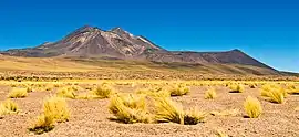
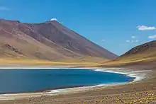
Miñiques is a massive volcanic complex containing a large number of craters, lava domes and flows, located in the Antofagasta Region of Chile. Located 21 km (13 mi) south of Volcán Chiliques and 26 km (16 mi) west of Cordón Puntas Negras, it is part of a frequently visited attraction conformed by the high plain lagoons Laguna Miscanti, Laguna Miñiques and the Cerro Miscanti volcano.
| Cerro Miñiques | |
|---|---|
 The Miñiques volcano, seen from the Northwest. | |
| Highest point | |
| Elevation | 5,910 m (19,390 ft) |
| Coordinates | 23°49′0″S 67°46′0″W |
| Geography | |
| Location | Chile |
| Parent range | Andes |
| Geology | |
| Mountain type | Stratovolcano |
| Last eruption | Unknown |

Mountain
Miñiques has two summits, a lower northern summit which reaches 5,790 metres (19,000 ft) elevation and a higher southern one which is 5,910 metres (19,390 ft) high.[1] The mountain features two crater lakes, one at 5,450 metres (17,880 ft) and the other at 5,500 metres (18,000 ft) elevation[2] on the southeastern and western side of the northern summit, respectively.[1] A set of well developed moraines exists on the southern flank and may reflect glaciers advancing either from the summit area or a plateau at 4,900 metres (16,100 ft) elevation;[2] overall however glaciation on Miñiques was of limited extent[3] and the terrain of Miñiques today is dominated by periglacial processes. Laguna Miñiques lies on its northwestern foot;[1] it was separated from Laguna Miscanti by a lava flow from Miñiques.[4]
The mountain rises from a 4,100 metres (13,500 ft) high ignimbrite plateau. It is of Pleistocene age and formed by andesitic and dacitic rocks; the volcano is classified as extinct,[5] but activity of the Pliocene-Pleistocene volcano may have continued into the Holocene. There are a number of craters, some of which contain lava domes and lava flows.[4] Stone structures and archeological sites are found on the summit and the flanks of Miñiques mountain,[6] and the church of Socaire is oriented towards the mountain.[7] The Inca associated the mountain with the god Tunupa and with lightning.[8]
See also
References
- Schröder 1999, p. 122.
- Schröder, Hilmar (1 September 2001). "Kommentar zu den Anmerkungen von Bettina Jenny, Klaus Kammer und Bruno Messerli (Erdkunde 55, 2001)". Erdkunde (in German). 55 (3): 290. doi:10.3112/erdkunde.2001.03.07.
- Schröder 1999, p. 128.
- "Miñiques". Global Volcanism Program. Smithsonian Institution.
- Schröder 1999, p. 126.
- Moyano, Ricardo (2011). "Sub-tropical astronomy in the southern Andes: the ceque system in Socaire, Atacama, northern Chile†". Proceedings of the International Astronomical Union. 7 (S278): 100. doi:10.1017/S1743921311012518. ISSN 1743-9221.
- Moyano, Ricardo (1 January 2015). Landscape, Mountain Worship and Astronomy in Socaire. Handbook of Archaeoastronomy and Ethnoastronomy. Springer New York. pp. 921–929. doi:10.1007/978-1-4614-6141-8_92. ISBN 978-1-4614-6140-1.
- Valenzuela, América; Moyano, Ricardo. "Ethnicity and Ritual in the Atacameños Andes: Water, Mountains, and Irrigation Channels in Socaire (Atacama, Chile)". Andean Foodways: Pre-Columbian, Colonial, and Contemporary Food and Culture. Springer International Publishing. p. 429. ISBN 978-3-030-51629-1.
Sources
- Schröder, Hilmar (1999). "Vergleichende Periglazialmorphologie im Sommerregengebiet der Atacama". Erdkunde (in German). 53 (2): 119–135. doi:10.3112/erdkunde.1999.02.03. ISSN 0014-0015. OCLC 998216719, 1006241123.CS1 maint: ref=harv (link)
Further sources
External links
| Wikimedia Commons has media related to Miñiques. |
- SI Google Earth Placemarks - Smithsonian Institution Global Volcanism Program: download placemarks with SI Holocene volcano-data.