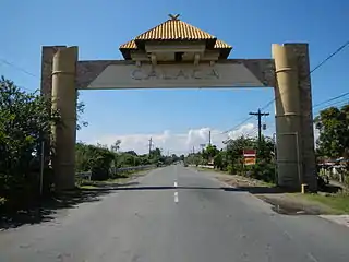
Calaca, Batangas
Calaca, officially the Municipality of Calaca (Tagalog: Bayan ng Calaca), is a 1st class municipality in the province of Batangas, Philippines. According to the 2015 census, it has a population of 81,859 people. [4]
Calaca | |
|---|---|
| Municipality of Calaca | |
 | |
 Seal | |
 Map of Batangas with Calaca highlighted | |
OpenStreetMap 
| |
.svg.png.webp) Calaca Location within the Philippines | |
| Coordinates: 13°58′N 120°48′E | |
| Country | |
| Region | Calabarzon (Region IV-A) |
| Province | Batangas |
| District | 1st District |
| Founded | May 10, 1835 [1] |
| Barangays | 40 (see Barangays) |
| Government | |
| • Type | Sangguniang Bayan |
| • Mayor | Sofronio Leonardo C. Ona Jr. |
| • Vice Mayor | Renante L. Macalindong |
| • Representative | Elenita R. Ermita-Buhain |
| • Electorate | 51,670 voters (2019) |
| Area | |
| • Total | 114.58 km2 (44.24 sq mi) |
| Elevation | 49 m (161 ft) |
| Population | |
| • Total | 81,859 |
| • Density | 710/km2 (1,900/sq mi) |
| • Households | 17,707 |
| Economy | |
| • Income class | 1st municipal income class |
| • Poverty incidence | 17.36% (2015)[5] |
| • Revenue | ₱361,602,200.36 (2016) |
| Time zone | UTC+8 (PST) |
| ZIP code | 4212 |
| PSGC | |
| IDD : area code | +63 (0)43 |
| Climate type | tropical monsoon climate |
| Native languages | Tagalog |
| Website | calaca |
Calaca is home to the lively Calacatchara festival (a portmanteau of Calaca and atchara (chutney).
Geography
According to the Philippine Statistics Authority, the municipality has a land area of 114.58 square kilometres (44.24 sq mi) [3] constituting 3.67% of the 3,119.75-square-kilometre- (1,204.54 sq mi) total area of Batangas.
Barangays
Calaca is politically subdivided into 40 barangays.[6]
| PSGC | Barangay | Population | ±% p.a. | |||
|---|---|---|---|---|---|---|
| 2015 [4] | 2010 [7] | |||||
| 041007001 | Bagong Tubig | 3.0% | 2,434 | 2,083 | 3.01% | |
| 041007002 | Baclas | 2.1% | 1,688 | 1,574 | 1.34% | |
| 041007003 | Balimbing | 0.6% | 494 | 456 | 1.54% | |
| 041007004 | Bambang | 1.7% | 1,415 | 1,239 | 2.56% | |
| 041007006 | Barangay 1 (Poblacion) | 2.3% | 1,903 | 1,839 | 0.65% | |
| 041007007 | Barangay 2 (Poblacion) | 1.0% | 827 | 729 | 2.43% | |
| 041007008 | Barangay 3 (Poblacion) | 0.3% | 278 | 279 | −0.07% | |
| 041007009 | Barangay 4 (Poblacion) | 1.3% | 1,031 | 908 | 2.45% | |
| 041007010 | Barangay 5 (Poblacion) | 1.3% | 1,096 | 1,004 | 1.68% | |
| 041007011 | Barangay 6 (Poblacion) | 0.9% | 762 | 742 | 0.51% | |
| 041007012 | Bisaya | 1.2% | 1,016 | 861 | 3.20% | |
| 041007013 | Cahil | 4.6% | 3,742 | 2,929 | 4.77% | |
| 041007014 | Caluangan | 2.3% | 1,863 | 1,699 | 1.77% | |
| 041007015 | Calantas | 3.8% | 3,128 | 2,784 | 2.24% | |
| 041007016 | Camastilisan | 5.1% | 4,147 | 3,425 | 3.71% | |
| 041007017 | Coral ni Lopez (Sugod) | 2.3% | 1,921 | 1,695 | 2.41% | |
| 041007018 | Coral ni Bacal | 1.7% | 1,389 | 1,145 | 3.75% | |
| 041007019 | Dacanlao | 7.5% | 6,177 | 5,243 | 3.17% | |
| 041007020 | Dila | 2.0% | 1,624 | 1,504 | 1.47% | |
| 041007021 | Loma | 1.6% | 1,346 | 1,112 | 3.70% | |
| 041007022 | Lumbang Calzada | 3.4% | 2,820 | 2,329 | 3.71% | |
| 041007023 | Lumbang na Bata | 2.3% | 1,873 | 1,769 | 1.09% | |
| 041007024 | Lumbang na Matanda | 3.1% | 2,549 | 1,944 | 5.29% | |
| 041007025 | Madalunot | 2.4% | 1,927 | 1,675 | 2.70% | |
| 041007027 | Makina | 1.6% | 1,301 | 1,094 | 3.35% | |
| 041007028 | Matipok | 2.2% | 1,830 | 1,515 | 3.66% | |
| 041007030 | Munting Coral | 0.5% | 387 | 328 | 3.20% | |
| 041007031 | Niyugan | 1.7% | 1,404 | 1,185 | 3.28% | |
| 041007032 | Pantay | 6.9% | 5,654 | 4,517 | 4.37% | |
| 041007033 | Puting Bato West | 4.0% | 3,291 | 2,892 | 2.49% | |
| 041007034 | Puting Kahoy | 1.6% | 1,310 | 1,179 | 2.03% | |
| 041007035 | Puting Bato East | 2.6% | 2,145 | 2,001 | 1.33% | |
| 041007036 | Quisumbing | 2.7% | 2,193 | 1,824 | 3.57% | |
| 041007037 | Salong | 5.8% | 4,766 | 4,130 | 2.76% | |
| 041007038 | San Rafael | 1.2% | 965 | 661 | 7.47% | |
| 041007039 | Sinisian | 2.5% | 2,025 | 1,764 | 2.66% | |
| 041007041 | Taklang Anak | 1.5% | 1,190 | 980 | 3.77% | |
| 041007042 | Talisay | 2.4% | 1,985 | 1,935 | 0.49% | |
| 041007043 | Tamayo | 1.9% | 1,590 | 1,435 | 1.97% | |
| 041007044 | Timbain | 2.9% | 2,373 | 2,114 | 2.22% | |
| Total | 81,859 | 70,521 | 2.88% | |||
Climate
| Climate data for Calaca, Batangas | |||||||||||||
|---|---|---|---|---|---|---|---|---|---|---|---|---|---|
| Month | Jan | Feb | Mar | Apr | May | Jun | Jul | Aug | Sep | Oct | Nov | Dec | Year |
| Average high °C (°F) | 29 (84) |
30 (86) |
31 (88) |
33 (91) |
32 (90) |
30 (86) |
29 (84) |
29 (84) |
29 (84) |
29 (84) |
29 (84) |
29 (84) |
30 (86) |
| Average low °C (°F) | 20 (68) |
20 (68) |
21 (70) |
22 (72) |
24 (75) |
24 (75) |
24 (75) |
24 (75) |
24 (75) |
23 (73) |
22 (72) |
21 (70) |
22 (72) |
| Average precipitation mm (inches) | 11 (0.4) |
13 (0.5) |
14 (0.6) |
32 (1.3) |
101 (4.0) |
142 (5.6) |
208 (8.2) |
187 (7.4) |
175 (6.9) |
131 (5.2) |
68 (2.7) |
39 (1.5) |
1,121 (44.3) |
| Average rainy days | 5.2 | 5.0 | 7.4 | 11.5 | 19.8 | 23.5 | 27.0 | 25.9 | 25.2 | 23.2 | 15.5 | 8.3 | 197.5 |
| Source: Meteoblue (Use with caution: this is modeled/calculated data, not measured locally.) [8] | |||||||||||||
Demographics
|
| ||||||||||||||||||||||||||||||||||||||||||||||||
| Source: Philippine Statistics Authority [4] [7] [9][10] | |||||||||||||||||||||||||||||||||||||||||||||||||
In the 2015 census, Calaca had a population of 81,859. [4] The population density was 710 inhabitants per square kilometre (1,800/sq mi).
Gallery
 Municipal hall
 Police station
 Public market
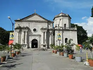 Saint Raphael the Archangel Parish Church
References
- https://balikasonline.wordpress.com/2015/10/29/on-its-180th-founding-anniversary-calaca-celebrates-the-11th-calacatchara-festival
- Municipality of Calaca | (DILG)
- "Province: Batangas". PSGC Interactive. Quezon City, Philippines: Philippine Statistics Authority. Retrieved 12 November 2016.
- Census of Population (2015). "Region IV-A (Calabarzon)". Total Population by Province, City, Municipality and Barangay. PSA. Retrieved 20 June 2016.
- "PSA releases the 2015 Municipal and City Level Poverty Estimates". Quezon City, Philippines. Retrieved 1 January 2020.
- "Municipal: Calaca, Batangas". PSGC Interactive. Quezon City, Philippines: Philippine Statistics Authority. Retrieved 8 January 2016.
- Census of Population and Housing (2010). "Region IV-A (Calabarzon)". Total Population by Province, City, Municipality and Barangay. NSO. Retrieved 29 June 2016.
- "Calaca: Average Temperatures and Rainfall". Meteoblue. Retrieved 5 May 2020.
- Censuses of Population (1903–2007). "Region IV-A (Calabarzon)". Table 1. Population Enumerated in Various Censuses by Province/Highly Urbanized City: 1903 to 2007. NSO.
- "Province of Batangas". Municipality Population Data. Local Water Utilities Administration Research Division. Retrieved 17 December 2016.
External links
| Wikimedia Commons has media related to Calaca, Batangas. |
Places adjacent to Calaca, Batangas | |
|---|---|
Batangas (capital) | |
| Municipalities | |
| Component cities | |
| Authority control |
|---|
This article is issued from Wikipedia. The text is licensed under Creative Commons - Attribution - Sharealike. Additional terms may apply for the media files.