San Nicolas, Batangas
San Nicolas, officially the Municipality of San Nicolas (Tagalog: Bayan ng San Nicolas), is a 5th class municipality in the province of Batangas, Philippines. According to the 2015 census, it has a population of 22,623 people. [5]
San Nicolas | |
|---|---|
| Municipality of San Nicolas | |
 San Nicolas welcome arch | |
 Seal | |
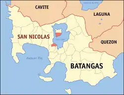 Map of Batangas with San Nicolas highlighted | |
OpenStreetMap 
| |
.svg.png.webp) San Nicolas Location within the Philippines | |
| Coordinates: 13°55′42″N 120°57′04″E | |
| Country | |
| Region | Calabarzon (Region IV-A) |
| Province | Batangas |
| District | 3rd District |
| Founded | June 1, 1955 [1] |
| Named for | St. Nicholas of Tolentino[2] |
| Barangays | 18 (see Barangays) |
| Government | |
| • Type | Sangguniang Bayan |
| • Mayor | Lester D. De Sagun |
| • Vice Mayor | Napoleon V. Arceo |
| • Representative | Ma. Theresa V. Collantes |
| • Electorate | 16,858 voters (2019) |
| Area | |
| • Total | 14.37 km2 (5.55 sq mi) |
| Elevation | 47 m (154 ft) |
| Population | |
| • Total | 22,623 |
| • Density | 1,600/km2 (4,100/sq mi) |
| • Households | 4,473 |
| Economy | |
| • Income class | 5th municipal income class |
| • Poverty incidence | 12.12% (2015)[6] |
| • Revenue | ₱64,364,110.64 (2016) |
| Time zone | UTC+8 (PST) |
| ZIP code | 4207 |
| PSGC | |
| IDD : area code | +63 (0)43 |
| Climate type | tropical monsoon climate |
| Native languages | Tagalog |
It is the smallest municipality in Batangas with 14.37 square kilometres (5.55 sq mi) [4] of land area, which includes the southern half of Taal Volcano.
History
In 1955, the barrios of San Nicolas, Hipit, Bangin, Pansipit, Calangay, Sinturisan, Talang, Abelo, Balete, Bancoro, Saimsim, Maabud, Munlawin, Tambo, Calumala, Alas-as, Calawit, and Pulang-Bato, then part of the municipality of Taal, were separated and constituted into a new and separate municipality known as San Nicolas.[7]
Geography
According to the Philippine Statistics Authority, the municipality has a land area of 14.37 square kilometres (5.55 sq mi) [4] constituting 0.46% of the 3,119.75-square-kilometre- (1,204.54 sq mi) total area of Batangas.
Barangays
San Nicolas is politically subdivided into 18 barangays.[8]
In 1957, the following sitios converted into independent barrios: Burol from Tambo,[9] Tagudtod from Munlawin,[10] Kalawit and Pulang-Bato from Alas-as,[11][12] and Baluk-Baluk from Hipit.[13]
| PSGC | Barangay | Population | ±% p.a. | |||
|---|---|---|---|---|---|---|
| 2015 [5] | 2010 [14] | |||||
| 041025001 | Abelo | 4.3% | 978 | 869 | 2.28% | |
| 041025002 | Balete | 8.1% | 1,822 | 1,759 | 0.67% | |
| 041025003 | Baluk‑baluk | 4.0% | 916 | 804 | 2.51% | |
| 041025004 | Bancoro | 11.7% | 2,648 | 2,549 | 0.73% | |
| 041025005 | Bangin | 8.9% | 2,008 | 1,910 | 0.96% | |
| 041025006 | Calangay | 8.1% | 1,834 | 1,651 | 2.02% | |
| 041025007 | Hipit | 2.8% | 623 | 571 | 1.67% | |
| 041025009 | Maabud North | 4.4% | 991 | 982 | 0.17% | |
| 041025010 | Maabud South | 3.1% | 696 | 682 | 0.39% | |
| 041025011 | Munlawin | 4.3% | 976 | 774 | 4.51% | |
| 041025012 | Pansipit | 2.0% | 446 | 422 | 1.06% | |
| 041025013 | Poblacion | 11.0% | 2,481 | 2,416 | 0.51% | |
| 041025014 | Santo Niño | 4.1% | 919 | 826 | 2.05% | |
| 041025015 | Sinturisan | 8.6% | 1,947 | 1,710 | 2.50% | |
| 041025016 | Tagudtod | 2.8% | 631 | 623 | 0.24% | |
| 041025017 | Talang | 3.2% | 721 | 667 | 1.49% | |
| 041025018 | Alas‑as | 5.9% | 1,327 | 901 | 7.65% | |
| 041025019 | Pulang‑Bato | 2.9% | 659 | 483 | 6.09% | |
| Total | 22,623 | 20,599 | 1.80% | |||
Climate
| Climate data for San Nicolas, Batangas | |||||||||||||
|---|---|---|---|---|---|---|---|---|---|---|---|---|---|
| Month | Jan | Feb | Mar | Apr | May | Jun | Jul | Aug | Sep | Oct | Nov | Dec | Year |
| Average high °C (°F) | 29 (84) |
30 (86) |
31 (88) |
33 (91) |
32 (90) |
30 (86) |
29 (84) |
29 (84) |
29 (84) |
29 (84) |
29 (84) |
29 (84) |
30 (86) |
| Average low °C (°F) | 20 (68) |
20 (68) |
21 (70) |
22 (72) |
24 (75) |
24 (75) |
24 (75) |
24 (75) |
24 (75) |
23 (73) |
22 (72) |
21 (70) |
22 (72) |
| Average precipitation mm (inches) | 11 (0.4) |
13 (0.5) |
14 (0.6) |
32 (1.3) |
101 (4.0) |
142 (5.6) |
208 (8.2) |
187 (7.4) |
175 (6.9) |
131 (5.2) |
68 (2.7) |
39 (1.5) |
1,121 (44.3) |
| Average rainy days | 5.2 | 5.0 | 7.4 | 11.5 | 19.8 | 23.5 | 27.0 | 25.9 | 25.2 | 23.2 | 15.5 | 8.3 | 197.5 |
| Source: Meteoblue [15] | |||||||||||||
Demographics
| Year | Pop. | ±% p.a. |
|---|---|---|
| 1960 | 9,575 | — |
| 1970 | 8,742 | −0.90% |
| 1975 | 8,877 | +0.31% |
| 1980 | 10,511 | +3.44% |
| 1990 | 13,174 | +2.28% |
| 1995 | 14,509 | +1.83% |
| 2000 | 16,278 | +2.50% |
| 2007 | 19,046 | +2.19% |
| 2010 | 20,599 | +2.89% |
| 2015 | 22,623 | +1.80% |
| Source: Philippine Statistics Authority [5] [14] [16][17] | ||
In the 2015 census, San Nicolas had a population of 22,623. [5] The population density was 1,600 inhabitants per square kilometre (4,100/sq mi).
References
- http://www.chanrobles.com/republicacts/republicactno1229.html
- http://calabarzon.dilg.gov.ph/130-old-lgus/old-batangas-lgus/535-san-nicolas
- Municipality of San Nicolas | (DILG)
- "Province: Batangas". PSGC Interactive. Quezon City, Philippines: Philippine Statistics Authority. Retrieved 12 November 2016.
- Census of Population (2015). "Region IV-A (Calabarzon)". Total Population by Province, City, Municipality and Barangay. PSA. Retrieved 20 June 2016.
- "PSA releases the 2015 Municipal and City Level Poverty Estimates". Quezon City, Philippines. Retrieved 1 January 2020.
- "An Act Creating the Municipality of San Nicolas, Province of Batangas". LawPH.com. Retrieved 2011-04-11.
- "Municipal: San Nicolas, Batangas". PSGC Interactive. Quezon City, Philippines: Philippine Statistics Authority. Retrieved 8 January 2016.
- "An Act Creating the Barrio of Burol in the Municipality of San Nicolas, Province of Batangas". LawPH.com. Retrieved 2011-04-12.
- "An Act Creating the Barrio of Tagodtod in the Municipality of San Nicolas, Province of Batangas". LawPH.com. Retrieved 2011-04-12.
- "An Act Creating the Barrio of Kalawit in the Municipality of San Nicolas, Province of Batangas". LawPH.com. Retrieved 2011-04-12.
- "An Act Creating the Barrio of Pulang-bato in the Municipality of San Nicolas, Province of Batangas". LawPH.com. Retrieved 2011-04-12.
- "An Act Creating the Barrio of Baluk-balok in the Municipality of San Nicolas, Province of Batangas". LawPH.com. Retrieved 2011-04-12.
- Census of Population and Housing (2010). "Region IV-A (Calabarzon)". Total Population by Province, City, Municipality and Barangay. NSO. Retrieved 29 June 2016.
- "San Nicolas: Average Temperatures and Rainfall". Meteoblue. Retrieved 5 May 2020.
- Censuses of Population (1903–2007). "Region IV-A (Calabarzon)". Table 1. Population Enumerated in Various Censuses by Province/Highly Urbanized City: 1903 to 2007. NSO.
- "Province of Batangas". Municipality Population Data. Local Water Utilities Administration Research Division. Retrieved 17 December 2016.
External links
| Wikimedia Commons has media related to San Nicolas, Batangas. |
Places adjacent to San Nicolas, Batangas | |
|---|---|
Batangas (capital) | |
| Municipalities | |
| Component cities | |