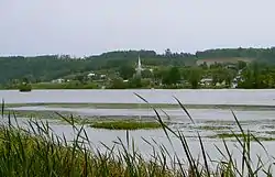
Campbell's Bay, Quebec
Campbell's Bay is a municipality in Pontiac Regional County Municipality in western Quebec, Canada. Its population in 2016 was 744.[3]
Campbell's Bay | |
|---|---|
 | |
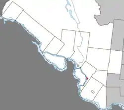 Location within Pontiac RCM | |
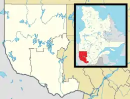 Campbell's Bay Location in western Quebec | |
| Coordinates: 45°44′N 76°36′W[1] | |
| Country | Canada |
| Province | Quebec |
| Region | Outaouais |
| RCM | Pontiac |
| Constituted | February 23, 1904 |
| Government | |
| • Mayor | Maurice Beauregard |
| • Federal riding | Pontiac |
| • Prov. riding | Pontiac |
| Area | |
| • Total | 3.50 km2 (1.35 sq mi) |
| • Land | 3.55 km2 (1.37 sq mi) |
| There is an apparent contradiction between two authoritative sources | |
| Population (2016)[3] | |
| • Total | 744 |
| • Density | 209.4/km2 (542/sq mi) |
| Time zone | UTC−5 (EST) |
| • Summer (DST) | UTC−4 (EDT) |
| Postal code(s) | J0X 1K0 |
| Area code(s) | 819 |
| Access Routes[4] | |
| Website | campbellsbay |
It is the county seat and is home to most government offices for the county, including the Sûreté du Québec, and has French and English elementary schools. Campbell's Bay is in the heart of the Pontiac, as it is situated between Shawville and Fort-Coulonge. It also lies completely enclosed by the municipality of Litchfield on all sides, with the exception of the Ottawa River to the west.
Campbell's Bay is the seat of the judicial district of Pontiac.[5]
History
The town was founded in 1904 and named for Lieutenant Donald Campbell, a member of the Scottish Regiment who settled in the area in 1851 and operated a sawmill.[6]
A hanging took place in 1935 in Campbell's Bay Court Yard. Michael Bradley was convicted for the murder of five family members. He was the last person to be hanged in Campbell's Bay.
Demographics
| Canada census – Campbell's Bay, Quebec community profile | |||
|---|---|---|---|
| 2016 | 2011 | 2006 | |
| Population: | 744 (-4.0% from 2011) | 775 (+4.0% from 2006) | 745 (-2.7% from 2001) |
| Land area: | 3.55 km2 (1.37 sq mi) | 3.54 km2 (1.37 sq mi) | 3.54 km2 (1.37 sq mi) |
| Population density: | 209.4/km2 (542/sq mi) | 219.1/km2 (567/sq mi) | 210.7/km2 (546/sq mi) |
| Median age: | 49.1 (M: 47.0, F: 50.5) | 45.2 (M: 41.8, F: 48.1) | 45.7 (M: 43.4, F: 47.4) |
| Total private dwellings: | 349 | 350 | 333 |
| Median household income: | $47,445 | $38,079 | $38,146 |
| References: 2016[7] 2011[8] 2006[9] earlier[10] | |||
| Year | Pop. | ±% |
|---|---|---|
| 1986 | 911 | — |
| 1991 | 912 | +0.1% |
| 1996 | 874 | −4.2% |
| 2001 | 766 | −12.4% |
| 2006 | 745 | −2.7% |
| 2011 | 775 | +4.0% |
| 2016 | 744 | −4.0% |
| Source: [11] | ||
Government
The town government comprises a mayor and 6 councilors.
Current council:
- Mayor: Maurice Beauregard
- Councillors: Raymond Pilon, Tim Ferrigan, Maurice Beauregard, Lisa Dagenais, Lois Smith and Suzanne Dubeau-Pilon
List of former mayors:
- Cletus Ferrigan (2002–2005)
- Jean-Louis Auger (2005–2009)
- William Stewart (2009–2017)
- Maurice Beauregard (2017–present)
Town festivals
- FallFest at the Church of Faith, Praise and Prayer
- Bikes in the Bay - weekend of motorcycle events, music, food and kids' activities on June 12, 13 & 14, 2009 visit www.bikesinthebay.com for more info
Transportation
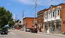
Quebec Route 148 and Quebec Route 301 (rue Leslie) are the main roads that connect into and out of Campbell's Bay. Front Street (rue Front) is the longest and main road within town.
There are no railway stations or airports within or near Campbell's Bay. The nearest major airport is Ottawa International Airport.
See also
References
- Reference number 379120 of the Commission de toponymie du Québec (in French)
- "Campbell's Bay". Répertoire des municipalités (in French). Ministère des Affaires municipales, des Régions et de l'Occupation du territoire. Archived from the original on 2012-05-01. Retrieved 2012-04-03.
- "(Code 2484030) Census Profile". 2016 census. Statistics Canada. 2017.
- Official Transport Quebec Road Map
- Territorial Division Act. Revised Statutes of Quebec D-11.
- http://outaouais.quebecheritageweb.com/article/campbell-house-campbell-s-bay
- "2016 Community Profiles". 2016 Canadian Census. Statistics Canada. February 21, 2017. Retrieved 2019-11-18.
- "2011 Community Profiles". 2011 Canadian Census. Statistics Canada. July 5, 2013. Retrieved 2014-01-28.
- "2006 Community Profiles". 2006 Canadian Census. Statistics Canada. March 30, 2011. Retrieved 2012-04-03.
- "2001 Community Profiles". 2001 Canadian Census. Statistics Canada. February 17, 2012.
- Statistics Canada: 1996, 2001, 2006, 2011 census
External links
| Wikimedia Commons has media related to Campbell's Bay, Quebec. |
- Elections Canada Results - 39th General Election (2006)
- Director General of Quebec Elections
- Official Transport Quebec Road Map
Adjacent Municipal Subdivisions | ||||||||||
|---|---|---|---|---|---|---|---|---|---|---|
| ||||||||||
| Municipalities | |
|---|---|
| Townships | |
| Villages | |
| Unorganized territories | |
| |
| Authority control |
|
|---|