Caramoan
Caramoan, officially the Municipality of Caramoan (Central Bicolano: Banwaan kan Caramoan; Tagalog: Bayan ng Caramoan), is a 2nd class municipality in the province of Camarines Sur, Philippines. According to the 2015 census, it has a population of 47,605 people. [6]
Caramoan | |
|---|---|
| Municipality of Caramoan | |
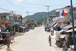 Caramoan town proper | |
 Map of Camarines Sur with Caramoan highlighted | |
.svg.png.webp) Caramoan Location within the Philippines | |
| Coordinates: 13°46′15″N 123°51′47″E | |
| Country | |
| Region | Bicol Region (Region V) |
| Province | Camarines Sur |
| District | 4th District |
| Barangays | 49 (see Barangays) |
| Government | |
| • Type | Sangguniang Bayan |
| • Mayor | Marilyn Socorro H. Co[2] |
| • Vice Mayor | Irene R. Breis[3] |
| • SB Members |
|
| • Representative | Arnulf Bryan B. Fuentebella |
| • Electorate | 31,886 voters (May, 2019)[4] |
| Area | |
| • Total | 276.00 km2 (106.56 sq mi) |
| Elevation | 61 m (200 ft) |
| Population | |
| • Total | 47,605 |
| • Density | 170/km2 (450/sq mi) |
| • Households | 9,878 |
| Economy | |
| • Income class | 2nd municipal income class |
| • Poverty incidence | 51.34% (2015)[7] |
| • Revenue | ₱123,416,089.20 (2016) |
| Time zone | UTC+8 (PST) |
| ZIP code | 4429 |
| PSGC | |
| IDD : area code | +63 (0)54 |
| Climate type | tropical rainforest climate |
| Native languages | Central Bikol Tagalog |
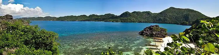
The municipality is located at the tip of the Caramoan Peninsula, a rugged place of land extending into the waters of the Maqueda Channel on the north and east and Lagonoy Gulf on the south. It has been dubbed as the Emerging Paradise of the Pacific due to its white and pink sand beaches known internationally.
Geography
Caramoan is bounded on the north by the town of Garchitorena and the Philippine Sea of the Pacific Ocean; on the north-east by the island province of Catanduanes; on the south by Lagonoy Gulf; on the east by the Maqueda Channel and on the west by the municipality of Presentacion.
The municipality covers approximately 277.41 square kilometres (107.11 sq mi) with approximately 71 kilometres (44 mi) of irregular coastline surrounded by the vast ocean, bay, seas and swamps. It is approximately 500 kilometres (310 mi) from Metro Manila; 95 kilometres (59 mi) from the municipality of Pili, where the seat of the provincial government and the Naga Domestic Airport are located; and 110 kilometres (68 mi) east from Naga City, the heart of Bicol.
Caramoan Islands
Off the coast of the peninsula are numerous small islets. The 10 principal islands of the group are:[8]
- Bag-ing
- Cagbanilad
- Catanhawan
- Cotivas
- Lahos
- Lahuy
- Matukad
- Minalahos
- Pitogo
- Sabitang-Laya
Barangays
Caramoan is politically subdivided into 49 barangays.
- Agaas
- Antolon
- Bacgong
- Bahay
- Bikal
- Binanuahan (Poblacion)
- Cabacongan
- Cadong
- Colongcogong
- Canatuan
- Caputatan
- Gogon
- Daraga
- Gata
- Gibgos
- Guijalo
- Hanopol
- Hanoy
- Haponan
- Ilawod
- Ili-Centro (Poblacion)
- Lidong
- Lubas
- Malabog
- Maligaya
- Mampirao
- Mandiclum
- Maqueda
- Minalaba
- Oring
- Oroc-Osoc
- Pagolinan
- Pandanan
- Paniman
- Patag-Belen
- Pili-Centro
- Pili-Tabiguian
- Poloan
- Salvacion
- San Roque
- San Vicente
- Santa Cruz
- Solnopan
- Tabgon
- Tabiguian
- Tabog
- Tawog (Poblacion)
- Toboan
- Terogo
Climate
| Climate data for Caramoan, Camarines Sur | |||||||||||||
|---|---|---|---|---|---|---|---|---|---|---|---|---|---|
| Month | Jan | Feb | Mar | Apr | May | Jun | Jul | Aug | Sep | Oct | Nov | Dec | Year |
| Average high °C (°F) | 30 (86) |
30 (86) |
32 (90) |
35 (95) |
35 (95) |
35 (95) |
34 (93) |
35 (95) |
33 (91) |
31 (88) |
31 (88) |
29 (84) |
33 (91) |
| Average low °C (°F) | 27 (81) |
27 (81) |
28 (82) |
31 (88) |
31 (88) |
31 (88) |
30 (86) |
30 (86) |
29 (84) |
28 (82) |
28 (82) |
26 (79) |
29 (84) |
| Average precipitation mm (inches) | 151.1 (5.95) |
198.89 (7.83) |
106.28 (4.18) |
60.08 (2.37) |
63.62 (2.50) |
85.76 (3.38) |
117.53 (4.63) |
46.99 (1.85) |
52.23 (2.06) |
740.22 (29.14) |
522.70 (20.58) |
618 (24.3) |
2,763.4 (108.77) |
| Average rainy days | 24 | 28 | 18 | 23 | 23 | 25 | 29 | 21 | 26 | 28 | 29 | 31 | 305 |
| Source: World Weather Online (Use with caution: this is modeled/calculated data, not measured locally.)[9] | |||||||||||||
History
The name Caramoan has been officially used since 1619, the year it was named by a Spanish missionary friar, Francisco de la Cruz Y Oropesa. Fr. Oropesa penetrated the thick virgin forest of the Caramoan Peninsula and founded a small settlement in a place called Baluarte. This settlement was subsequently turned over to the administration of the Holy Bishopric in 1696.
Prior to the arrival of the Spaniards, it was determined that the place was once called Guta de Leche, which was given by Dutch traders who operated a gold mine in Lahuy Island and who frequented the area to trade with the natives. The name was perhaps derived from the milkdrop stalagmites found among the rocks of Guta Port. Upon the arrival of the Spaniards, the place came to be called "Carahan" for the sea turtle, which was at that time to be found in great number along the shores of the Peninsula.
Demographics
|
| ||||||||||||||||||||||||||||||||||||||||||||||||
| Source: Philippine Statistics Authority [6] [10] [11][12] | |||||||||||||||||||||||||||||||||||||||||||||||||
In the 2015 census, the population of Caramoan was 47,605 people, [6] with a density of 170 inhabitants per square kilometre or 440 inhabitants per square mile.
Tourism
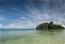
Tourist destinations include the Caramoan National Park, the Centro, and Gota Beach, where activities include diving, swimming, snorkeling and spelunking.
Survivor
Caramoan has been the site for several editions of the competitive reality television show Survivor. The area has hosted the U.S. version in two consecutive seasons (Survivor: Philippines and Survivor: Caramoan), the Serbian version for two consecutive seasons and the Israeli version for three consecutive seasons (** Survivor: The Philippines, Survivor: Fans vs. Survivors, Survivor: Camarines). Bulgarian Survivor also filmed its fourth season there in May to July 2009. Robinson 2010, the 12th season of the Swedish version of the franchise, was filmed in Caramoan from May to June 2010. Finnish versions were filmed in there in 2018 with all-celebrity cast, and in 2019 half-famous and half- regular people cast.
The 8th season of Koh-Lanta, the French edition of Survivor, also was shot there. TV director Corinne Vaillant stated that "the powdery sand, the coconuts on Gota beach and the neighboring islets are a 'dream' for the French people. We chose Caramoan because it’s really wild. It’s necessary that contestants don’t see anything other than nature for them to believe that they’re really lost in the wilds.”[13]
The only season of Survivor India was shot in Caramoan, with an Indian production crew spotted in the area in March 2011.[14]
The first season of Supraviețuitorul, a Romanian reality game based on Survivor was shot in Caramoan in the summer of 2016, as well as the first and second season of Robinsonův ostrov (Czech version).
In spring of 2016 the first season of the Slovenian version of Survivor Philippines was filmed on 4 different islands, including Catanaguan and Tayak.
References
- Municipality of Caramoan | (DILG)
- "LGU Directory - Caramoan". Local Government Academy.
- "LGU Directory - Caramoan". Local Government Academy.
- "Number of Registered Voters by Sex" (PDF). Commission on Elections.
- "Province: Camarines Sur". PSGC Interactive. Quezon City, Philippines: Philippine Statistics Authority. Retrieved 12 November 2016.
- Census of Population (2015). "Region V (Bicol Region)". Total Population by Province, City, Municipality and Barangay. PSA. Retrieved 20 June 2016.
- "PSA releases the 2015 Municipal and City Level Poverty Estimates". Quezon City, Philippines. Retrieved 1 January 2020.
- "Caramoan Islands". CaramoanIslands.com. Retrieved February 10, 2013.
- "Caramoan, Camarines Sur: Average Temperatures and Rainfall". World Weather Online. Retrieved 29 October 2017.
- Census of Population and Housing (2010). "Region V (Bicol Region)". Total Population by Province, City, Municipality and Barangay. NSO. Retrieved 29 June 2016.
- Censuses of Population (1903–2007). "Region V (Bicol Region)". Table 1. Population Enumerated in Various Censuses by Province/Highly Urbanized City: 1903 to 2007. NSO.
- "Province of Camarines Sur". Municipality Population Data. Local Water Utilities Administration Research Division. Retrieved 17 December 2016.
- Aguilar, Ephraim (May 8, 2008). "4th-class town well on the way to celeb status". Philippine Daily Inquirer. Archived from the original on February 12, 2012. Retrieved May 20, 2012.
- Talagtag, Jr., Anselmo (October 30, 2011). "How Caramoan wowed "Survivor India"". Manila Bulletin. Archived from the original on November 14, 2011. Retrieved September 15, 2012.
External links
| Wikimedia Commons has media related to Caramoan, Camarines Sur. |
- Caramoan Profile at PhilAtlas.com
- Philippine Standard Geographic Code
- Philippine Census Information
- Official Site of the Province of Camarines Sur
Places adjacent to Caramoan | |
|---|---|
Pili (capital) | |
| Municipalities | |
| Component city | |
| Independent component city |
|