Canaman
Canaman, officially the Municipality of Canaman (Central Bicolano: Banwaan kan Canaman; Tagalog: Bayan ng Canaman), is a 4th class municipality in the province of Camarines Sur, Philippines. According to the 2015 census, it has a population of 34,210 people. [3]
Canaman | |
|---|---|
| Municipality of Canaman | |
 | |
 Seal | |
| Nicknames: Citadel of Bicol Culture Birthplace of Tancong Vaca Guerilla Unit | |
| Motto(s): "Bangon Canaman!" ("Rise Canaman!") | |
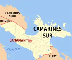 Map of Camarines Sur with Canaman highlighted | |
OpenStreetMap 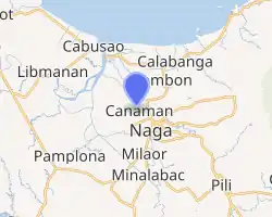
| |
.svg.png.webp) Canaman Location within the Philippines | |
| Coordinates: 13°39′N 123°10′E | |
| Country | |
| Region | Bicol Region (Region V) |
| Province | Camarines Sur |
| District | 3rd district |
| Founded | 1583 |
| Barangays | 24 (see Barangays) |
| Government | |
| • Type | Sangguniang Bayan |
| • Mayor | Nelson M. Legaspi |
| • Vice Mayor | Venancio B. Regulado |
| • Representative | Gabriel H. Bordado Jr. |
| • Electorate | 20,446 voters (2019) |
| Area | |
| • Total | 43.27 km2 (16.71 sq mi) |
| Elevation | 4.0 m (13.1 ft) |
| Population | |
| • Total | 34,210 |
| • Density | 790/km2 (2,000/sq mi) |
| • Households | 6,968 |
| Economy | |
| • Income class | 4th municipal income class |
| • Poverty incidence | 30.83% (2015)[4] |
| • Revenue | ₱79,553,923.66 (2016) |
| Time zone | UTC+8 (PST) |
| ZIP code | 4402 |
| PSGC | |
| IDD : area code | +63 (0)54 |
| Climate type | tropical rainforest climate |
| Native languages | Central Bikol Tagalog |
Etymology
The area that is now Canaman used to very thickly forested. According to Fr. Frank Lynch, S.J., who said that Canaman is the purest among Bicol dialects: “The name Canaman is locally said to be derived from the root kana, meaning "building materials". The suffix -man is taken as a locative, the name thus indicating “place where there are building materials”.[5]
History
Spanish colonization in Canaman began around the 1580s when some Nueva Caceres-based missionaries apparently on their way back from gospel work in either the visita of Quipayo (now Calabanga) or San Gabriel (now a barangay of Pamplona), got their bearings confused and, thinking they were turning eastward from the Bicol River to its Naga tributary, instead entered the Canaman creek which at the time was still a deep and fast flowing stream. They continued paddling until they ended up at a native settlement in what is now the barangay of Poro.
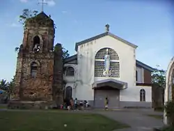
In June 1583, the place was organized into a parish, administered by Fray Pedro Matias de Andrade, a Franciscan who later became the fifth Bishop of Diocese of Caceres. In the 1590s, its church was constructed, which was rebuilt in 1669.[5] The patron saint at that time was San Roque, whose image, said to have come all the way from Spain was met at its arrival by the people of Canaman in the shores of Pasacao.
Philippine-American War
In 1900, after militant Canamanons heard that the Americans were closing in, they burned the church to the ground in an act of self-immolation to prevent desecration of the church at the hands of the new imperialists.[5] The burning was a deliberate and intentional act: the arsonists even gathered and piled on top of the church’s expensive organ dry grass and big tree branches to which they touched the match, to make certain that the fire consumed all combustible parts of the 231-year-old building and its interiors.
In 1902, during the provincial governorship of Captain George Curry, the Municipality of Canaman and its office of the presidente municipal was dissolved and lost its independent existence.[5] Canaman was annexed to Nueva Caceres (now Naga City), though some barrio were attached to Magarao and Canaman’s top position of presidente municipal was downgraded to concejal encargado.
Public educational system reached Canaman in 1903 with the arrival of a certain Miss Long, an American schoolteacher. She opened the first school now known as Canaman Central School in Dinaga, at the house of Don Basilio Severo (at the spot where the Facoma building stands at present) which the government rented.
In 1909, Canaman regained its status as an independent municipality, when it was separated from Nueva Caceres by an act of the First Philippine Legislature. This was mainly due to the efforts of Tomas Arejola, the representative of the first district of Ambos Camarines to the first legislature.[5]
World War II
On March 8, 1942, three months after Japanese Imperial Forces landed in Legaspi and Naga City, the Tangcong Vaca Guerilla Unit (TVGU) was organized in Barangay San Nicolas, with Juan Miranda as the Commanding Officer, Leon Aureus as the Executive Officer and Elias Madrid as the Finance Officer.[5] Among the numerous taga-Canaman who joined-up soon afterwards either in the unit’s intelligence or combat components were Jose and Antonio Madrid, Mamerto Sibulo, Andres Fortaleza, Marcos Severo, Damaso Avenilla, Federico Crescini, Nicolas Vargas, Venancio Begino, Eugenio Ragodon, Juan Pachica, Santiago Amaro, Jose Gervas, Pedro Angeles, Aproniano Lopez, Andres Alzate, Modesto Sanchez, Blas Alcantara, Andres Aguilar, Florencio Frondozo, Alfredo de la Torre and Flaviano Estrada.
In April 1945, Canaman was liberated by the 5th, 52nd, 53rd, 55th, 56th and 57th Infantry Divisions of the Philippine Commonwealth Army and the Bicolano guerrilla resistance fighters of the Tangcong Vaca Guerrilla Unit (TVGU).
Geography
A landlocked municipality centrally located in the province of Camarines Sur, it is bounded on the north by Magarao, on the south by Gainza and Camaligan, on the east by Naga City, and on the south-west by the broad Bicol River. From north to south it is 6 kilometres (3.7 mi) long, and 14 kilometres (8.7 mi) wide from east to west.
Climate
| Climate data for Canaman, Camarines Sur | |||||||||||||
|---|---|---|---|---|---|---|---|---|---|---|---|---|---|
| Month | Jan | Feb | Mar | Apr | May | Jun | Jul | Aug | Sep | Oct | Nov | Dec | Year |
| Average high °C (°F) | 32 (90) |
31 (88) |
34 (93) |
36 (97) |
37 (99) |
37 (99) |
36 (97) |
34 (93) |
35 (95) |
34 (93) |
33 (91) |
32 (90) |
34 (94) |
| Average low °C (°F) | 27 (81) |
27 (81) |
29 (84) |
31 (88) |
32 (90) |
32 (90) |
31 (88) |
30 (86) |
30 (86) |
29 (84) |
28 (82) |
28 (82) |
30 (85) |
| Average precipitation mm (inches) | 39.34 (1.55) |
68.7 (2.70) |
26.73 (1.05) |
66.19 (2.61) |
84.49 (3.33) |
178.89 (7.04) |
244.27 (9.62) |
188.3 (7.41) |
160.98 (6.34) |
445 (17.5) |
135.5 (5.33) |
367.8 (14.48) |
2,006.19 (78.96) |
| Average rainy days | 16 | 18 | 13 | 15 | 23 | 28 | 30 | 24 | 26 | 27 | 25 | 29 | 274 |
| Source: World Weather Online (Use with caution: this is modeled/calculated data, not measured locally.)[6] | |||||||||||||
Barangays
Canaman is politically subdivided into 24 barangays.
Demographics
|
| |||||||||||||||||||||||||||||||||||||||||||||
| Source: Philippine Statistics Authority [3] [7] [8][9] | ||||||||||||||||||||||||||||||||||||||||||||||
In the 2015 census, the population of Canaman was 34,210 people, [3] with a density of 790 inhabitants per square kilometre or 2,000 inhabitants per square mile.
Economy
Farming, fishing, and small business are the primary sources of employment and household income.[10]
While most of the people's market activities are done in Naga City, Canaman has a public market and a privately owned "talipapa". Two agro-industrial establishments are found in Canaman: the poultry feeds and palay.
Various types of cottage industries like handicraft, furniture, fan making (made of anahaw), ragiwdiw and nipa shingles are conducted in this town.[10]
In 1998, it was recorded that agricultural workers made up only 27.3% of the work force while 70.8% were engaged in non-agricultural activities. 88.38% of the total land area is devoted to agriculture.
In 2014, Canaman Dragon Boat Camp was launched in the village of Mangayawan along the Bicol River which serves as the turf of the Bicol River Hot Paddlers.[11]
Culture
Every month of May, the community honors the Holy Cross through Lagaylay, a tradition which began over a century ago. For nine nights, women dance on the church or a chapel's square while chanting prayers to the Cross.
Transportation
Most of the roads and main streets in the poblacion (urban barangays) are concrete with few earth and gravel roads, 4 can be reached only through water transportation while 11 can be reached either through water transportation and/or by land transportation.
References
- Municipality of Canaman | (DILG)
- "Province: Camarines Sur". PSGC Interactive. Quezon City, Philippines: Philippine Statistics Authority. Retrieved 12 November 2016.
- Census of Population (2015). "Region V (Bicol Region)". Total Population by Province, City, Municipality and Barangay. PSA. Retrieved 20 June 2016.
- "PSA releases the 2015 Municipal and City Level Poverty Estimates". Quezon City, Philippines. Retrieved 1 January 2020.
- "History". About Canaman. Local Government Unit of Canaman. Retrieved 4 January 2013.
- "Canaman, Camarines Sur: Average Temperatures and Rainfall". World Weather Online. Retrieved 29 October 2017.
- Census of Population and Housing (2010). "Region V (Bicol Region)". Total Population by Province, City, Municipality and Barangay. NSO. Retrieved 29 June 2016.
- Censuses of Population (1903–2007). "Region V (Bicol Region)". Table 1. Population Enumerated in Various Censuses by Province/Highly Urbanized City: 1903 to 2007. NSO.
- "Province of Camarines Sur". Municipality Population Data. Local Water Utilities Administration Research Division. Retrieved 17 December 2016.
- "Economy". About Canaman. Local Government Unit of Canaman. Retrieved 4 January 2013.
- Canaman holds first Dragon Boat race Bicol Mail
External links
- LGU-Canaman
- Canaman Profile at PhilAtlas.com
- Philippine Standard Geographic Code
- Philippine Census Information
Statistically grouped with the Province of Camarines Sur | |||||||
| Administrative divisions |
|  | |||||
| Geography | |||||||
| History | |||||||
| Religion |
| ||||||
| Public utilities and services |
| ||||||
| Transportation |
| ||||||
| Education |
| ||||||
| Landmarks | |||||||
| |||||||
Pili (capital) | |
| Municipalities | |
| Component city | |
| Independent component city |
|