Ocampo, Camarines Sur
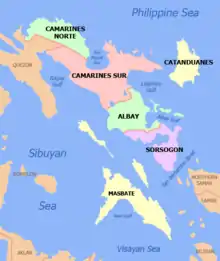
Ocampo, officially the Municipality of Ocampo (Central Bicolano: Banwaan kan Ocampo; Rinconada Bikol: Banwāan ka Ocampo; Tagalog: Bayan ng Ocampo), is a 3rd class municipality in the province of Camarines Sur, Philippines.
Ocampo | |
|---|---|
| Municipality of Ocampo | |
 Municipal Hall | |
Seal | |
| Motto(s): Padagos Ocampo! | |
 Map of Camarines Sur with Ocampo highlighted | |
OpenStreetMap 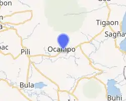
| |
.svg.png.webp) Ocampo Location within the Philippines | |
| Coordinates: 13°33′34″N 123°22′34″E | |
| Country | |
| Region | Bicol Region (Region V) |
| Province | Camarines Sur |
| District | 3rd district |
| Founded | 1949 |
| Barangays | 25 (see Barangays) |
| Government | |
| • Type | Sangguniang Bayan |
| • Mayor | Ronald Allan J. Go |
| • Vice Mayor | Eliseo C. Garcia |
| • Representative | Gabriel H. Bordado Jr. |
| • Electorate | 27,610 voters (2019) |
| Area | |
| • Total | 118.33 km2 (45.69 sq mi) |
| Elevation | 109 m (358 ft) |
| Population | |
| • Total | 45,934 |
| • Density | 390/km2 (1,000/sq mi) |
| • Households | 9,267 |
| Economy | |
| • Income class | 3rd municipal income class |
| • Poverty incidence | 35.04% (2015)[4] |
| • Revenue | ₱102,380,149.57 (2016) |
| Time zone | UTC+8 (PST) |
| ZIP code | 4419 |
| PSGC | |
| IDD : area code | +63 (0)54 |
| Climate type | tropical rainforest climate |
| Native languages | Central Bikol Inagta Partido Tagalog |
| Website | ocampo |
According to the 2015 census, it has a population of 45,934 people. [3]
History
The municipality of Ocampo traced its existence as the former “Mission de Mabatobato” launched by the Franciscan friars in 1735. The place was named “Mabatobato” because of the presence of huge rocks scattered all over the place believed to have erupted from Mt. Isarog. As a mission, it has four barrios; Ayugan, Tinablanan, Pinit and Moriones.
In the early 1800s, people from neighboring towns began to flock the area to settle and till the vast areas of lands suited for agriculture. The place began to flourish that the people began to dream of transforming the settlement into a new municipality. Cabeza de Barangay Michael Alcantara and Don Jose Barangbang requested and pleaded to the Bishop of Caceres to make the barrio into a town. The request was granted.
In 1917, Mabatobato was annexed to the municipality of Pili to help it recover from the Spanish–American War and for effective governance. By 1922 it was made into a new parish. Baptisms and burials were first recorded that year. The place began to flourish again and influx of immigrants from neighboring towns as well as from Batangas and Tayabas were observed.
After three decades, the leaders and the people of Mabatobato began to clamor for independence and to govern themselves once again. In 1948, during the incumbency of Congressman Sebastian C. Moll, Jr., 2nd District Camarines Sur, the dream to separate had been brewed. President Elpidio Quirino signed Executive Order No. 243 dated 15 July 1949 entitled: “Organizing Certain Barrios of the Municipality of Pili, Camarines Sur, into an Independent Municipality under the name of OCAMPO”.[5][6]

Mabatobato was renamed in honor of Don Julian Ocampo who was the Governor of Camarines Sur in the 1930s. Upon the appointment and qualification of the first municipal officials, Ocampo has begun to officially exist as an independent municipality on August 10, 1949.[7]
Barangays
Ocampo is politically subdivided into 25 barangays.
- Ayugan
- Cabariwan
- Cagmanaba
- Del Rosario
- Gatbo
- Guinaban
- Hanawan
- Hibago
- La Purisima Nuevo
- May-Ogob
- New Moriones
- Old Moriones
- Pinit
- Poblacion Central
- Poblacion East
- Poblacion West
- Salvacion
- San Antonio
- San Francisco
- San Jose Oras
- San Roque Commonal
- San Vicente
- Santa Cruz
- Santo Niño
- Villaflorida
Demographics
|
| ||||||||||||||||||||||||||||||||||||
| Source: Philippine Statistics Authority [3] [8] [9][10] | |||||||||||||||||||||||||||||||||||||
In the 2015 census, the population of Ocampo, Camarines Sur, was 45,934 people, [3] with a density of 390 inhabitants per square kilometre or 1,000 inhabitants per square mile.
Language

The Partido variant of Central Bikolano is the primary language spoken in the entire town. Riŋkonāda or Rinconada Bikol is spoken by a minority of the population, along with the Naga variant of Central Bikolano. Tagalog and English are also spoken and understood.
Isarog Agta Language
In 2010, UNESCO released its 3rd world volume of Endangered Languages in the World, where 3 critically endangered languages were in the Philippines. One of these languages in the Isarog Agta language which has an estimated speaker of 5 people in the year 2000. The language was classified as Critically Endangered, meaning the youngest speakers are grandparents and older, and they speak the language partially and infrequently and hardly pass the language to their children and grandchildren anymore. If the remaining 150 people do not pass their native language to the next generation of Isarog Agta people, their indigenous language will be extinct within a period of 1 to 2 decades.
The Isarog Agta people live within the circumference of Mount Isarog, though only 5 of them still know their indigenous language. They are one of the original Negrito settlers in the entire Philippines. They belong to the Aeta people classification, but have distinct language and belief systems unique to their own culture and heritage.
Religion
The religious groups in the locality are: Roman Catholic, Seventh Day Adventist, The Church of Jesus Christ of Latter Day Saints, Jehovah's Witnesses, Iglesia Ni Cristo, Word International Ministries and other groups of Born-Again Christians.
Climate
| Climate data for Ocampo, Camarines Sur | |||||||||||||
|---|---|---|---|---|---|---|---|---|---|---|---|---|---|
| Month | Jan | Feb | Mar | Apr | May | Jun | Jul | Aug | Sep | Oct | Nov | Dec | Year |
| Average high °C (°F) | 33 (91) |
32 (90) |
35 (95) |
37 (99) |
38 (100) |
36 (97) |
35 (95) |
33 (91) |
35 (95) |
34 (93) |
33 (91) |
32 (90) |
34 (94) |
| Average low °C (°F) | 27 (81) |
27 (81) |
29 (84) |
31 (88) |
32 (90) |
32 (90) |
31 (88) |
29 (84) |
30 (86) |
29 (84) |
28 (82) |
28 (82) |
29 (85) |
| Average precipitation mm (inches) | 36.66 (1.44) |
58.6 (2.31) |
37.91 (1.49) |
76.31 (3.00) |
98.34 (3.87) |
151.99 (5.98) |
288.39 (11.35) |
291.41 (11.47) |
186.77 (7.35) |
363.21 (14.30) |
97.5 (3.84) |
292.1 (11.50) |
1,979.19 (77.9) |
| Average rainy days | 18 | 23 | 16 | 17 | 25 | 28 | 31 | 26 | 27 | 29 | 24 | 29 | 293 |
| Source: World Weather Online[11] | |||||||||||||
Economy

Commercial establishments include internet shops, bank, pawnshops, hardware stores, groceries, drug stores, eateries, computer shops, bakeries, motorcycle dealers, agri-dealers, gas stations and several ricemills. Various businesses are sprouting.
Local products include palay, corn, root crops, sugarcane, coconut, and vegetables. Livestock and poultry products are also available.
CASURECO IV supplies power requirement in the town.
Tourism
Tourist destinations include the province-owned: Ocampo Deer Farm[12] in Barangay Santa Cruz, Bamboo Farm in Barangay Hanawan and Murokburok Spring in Barangay Gatbo. There's also Tera Mater Resort, the first resort in the town, located in Barangay New Moriones and a newly opened resort in Barangay San Antonio.
Ocampo Deer Farm is situated at an elevated area about four kilometers up in the forests of Mt. Isarog, in Barangay Santa Cruz, the 28-hectare reindeer farm is considered as the original reindeer farm of the Philippines. It was stocked entirely with Australian species such as Blackbuck Antelope, Fallow Deer, Chital Deer, Red Deer and Elk.
The farm was started late in 1996 with only 208 heads of five species from Australia. As of today, the number remains at 220 heads. Its goal was to make the province a supplier of deer meat (venison) which is a delicacy in class restaurants while the hides can be used as material for bags belts and other goods, and the antlers can be extracted for medicinal value.
Pacific Santa's Inc., founded by Santa R-Kayma Klaws, is entering an exclusive management agreement with the provincial government to micro-manage and promote the farm.
The Bicol Strawberry Farm owned by the Libreja family is found in Barangay Pinit.
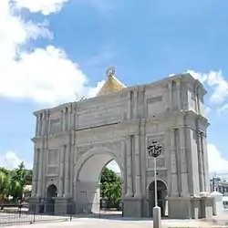
Fiestas and festivals
The town fiesta of Ocampo is celebrated in the month August in commemoration of the town's patron saint, Saint Bernard Abbot. The only festival at Ocampo is the Tinagba Festival which showcases the locally produced products of the town. It is celebrated annually during the month of August a week before the town fiesta. During this time, various activities are done.
Transportation
The town is the gateway to 4th District of Camarines Sur, and via Hanawan junction, Consocep falls northward and Iriga City southward. Accessible by land transportation, via National Highway going to Lagonoy, Camarines Sur. From Naga City, the easiest way to go to the town is to ride a bus going to Lagonoy from the Naga City Central Bus Terminal and disembark at Ocampo Poblacion bus stop.
Education
Elementary Schools
- Ocampo Evangelical School
- Ocampo Holy Saviour School Inc.
- Glorious Adonai Learning Academy
- Ocampo Central School
- Ayugan Elementary School
- Cabariwan Elementary School
- Del Rosario Elementary School
- Gatbo Elementary School
- Guinaban Elementary School
- Hanawan Elementary School
- Hibago Elementary School
- La Purisima Nuevo Elementary School
- May-Ogob Elementary School
- New Moriones Elementary School
- Pinit Elementary School
- San Antonio Elementary School
- San Jose Oras Elementary School
- San Roque Commonal Elementary School
- Santa Cruz Elementary School
- Santo Niño Elementary School
- Villaflorida Elementary School
High Schools
- Three secondary schools: Ocampo National High School in Barangay San Francisco, Malate-Olos High School in Barangay Cagmanaba and Hanawan High School in Barangay Hanawan.
Vocational Schools
- Ryden International and IConnect Global are the two TESDA schools offering vocational courses.
Notable People
- Bugoy Drilon - Singer under ABS-CBN and Second Star Dreamer of Pinoy Dream Academy Season 2[13]
- Kyline Alcantara (Kyline Nicole Aquino Manga) - Actress under GMA Network
References
- Municipality of Ocampo | (DILG)
- "Province: Camarines Sur". PSGC Interactive. Quezon City, Philippines: Philippine Statistics Authority. Retrieved 12 November 2016.
- Census of Population (2015). "Region V (Bicol Region)". Total Population by Province, City, Municipality and Barangay. PSA. Retrieved 20 June 2016.
- "PSA releases the 2015 Municipal and City Level Poverty Estimates". Quezon City, Philippines. Retrieved 1 January 2020.
- https://www.officialgazette.gov.ph/1949/07/15/executive-order-no-243-s-1949/
- http://www.officialgazette.gov.ph/downloads/1949/07jul/19490715-EO-0243-EQ.pdf
- http://ocampo.camarinessur.gov.ph/?page_id=74660
- Census of Population and Housing (2010). "Region V (Bicol Region)". Total Population by Province, City, Municipality and Barangay. NSO. Retrieved 29 June 2016.
- Censuses of Population (1903–2007). "Region V (Bicol Region)". Table 1. Population Enumerated in Various Censuses by Province/Highly Urbanized City: 1903 to 2007. NSO.
- "Province of Camarines Sur". Municipality Population Data. Local Water Utilities Administration Research Division. Retrieved 17 December 2016.
- "Ocampo, Camarines Sur: Average Temperatures and Rainfall". World Weather Online. Retrieved 29 October 2017.
- "A deer farm in Bicol", ABS-CBN News, Jan. 22, 2018
- "Bugoy Drilon Biography". hello.pinoystop.com. Retrieved 2020-08-01.
External links
| Wikimedia Commons has media related to Ocampo, Camarines Sur. |
- Ocampo Profile at PhilAtlas.com
- Philippine Standard Geographic Code
- Philippine Census Information
- Official Site of the Province of Camarines Sur
Places adjacent to Ocampo, Camarines Sur | ||||||||||
|---|---|---|---|---|---|---|---|---|---|---|
| ||||||||||
Statistically grouped with the Province of Camarines Sur | |||||||
| Administrative divisions |
|  | |||||
| Geography | |||||||
| History | |||||||
| Religion |
| ||||||
| Public utilities and services |
| ||||||
| Transportation |
| ||||||
| Education |
| ||||||
| Landmarks | |||||||
| |||||||
Pili (capital) | |
| Municipalities | |
| Component city | |
| Independent component city |
|
| Authority control |
|
|---|