Ragay, Camarines Sur
Ragay, officially the Municipality of Ragay (Central Bicolano: Banwaan kan Ragay; Tagalog: Bayan ng Ragay), is a 1st class municipality in the province of Camarines Sur, Philippines. According to the 2015 census, it has a population of 58,214 people. [3]
Ragay | |
|---|---|
| Municipality of Ragay | |
 Seal | |
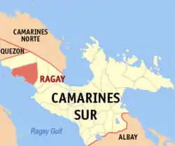 Map of Camarines Sur with Ragay highlighted | |
OpenStreetMap 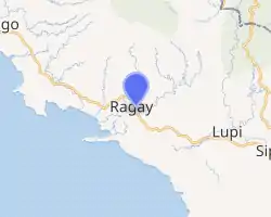
| |
.svg.png.webp) Ragay Location within the Philippines | |
| Coordinates: 13°49′06″N 122°47′32″E | |
| Country | |
| Region | Bicol Region (Region V) |
| Province | Camarines Sur |
| District | 1st district |
| Barangays | 38 (see Barangays) |
| Government | |
| • Type | Sangguniang Bayan |
| • Mayor | Thaddeus A. Ramos |
| • Vice Mayor | Elmer A. Linao |
| • Representative | Marissa Lourdes M. Andaya |
| • Electorate | 37,404 voters (2019) |
| Area | |
| • Total | 400.22 km2 (154.53 sq mi) |
| Elevation | 62 m (203 ft) |
| Population | |
| • Total | 58,214 |
| • Density | 150/km2 (380/sq mi) |
| • Households | 12,453 |
| Economy | |
| • Income class | 1st municipal income class |
| • Poverty incidence | 44.65% (2015)[4] |
| • Revenue | ₱152,585,345.48 (2016) |
| Time zone | UTC+8 (PST) |
| ZIP code | 4410 |
| PSGC | |
| IDD : area code | +63 (0)54 |
| Climate type | tropical rainforest climate |
| Native languages | Central Bikol Manide Tagalog |
| Website | ragay |
History
No date was known as to the establishment of the municipality of Ragay although it was recorded that the town was still a visita of Lupi on April 15, 1753.
Barangays
Ragay is politically subdivided into 38 barangay's.
- Agao-ao
- Agrupacion
- Amomokpok
- Apad
- Apale
- Banga Caves
- Baya
- Binahan Proper
- Binahan Upper
- Buenasuerte
- Cabadisan
- Cabinitan
- Cabugao
- Caditaan
- Cale
- Godofredo Reyes Sr.(Catabangan Crossing)
- Catabangan Proper
- Inandawa
- Laguio
- Lanipga-Cawayan
- Liboro
- Lohong
- Lower Omon
- Lower Santa Cruz
- Panaytayan
- Panaytayan Nuevo
- Patalunan
- Poblacion Ilaod
- Poblacion Iraya
- Port Junction Norte
- Port Junction Sur
- Salvacion
- Samay
- San Rafael
- F. Simeon (Pugod)
- Tagbac
- Upper Omon
- Upper Santa Cruz
Demographics
| Year | Pop. | ±% p.a. |
|---|---|---|
| 1903 | 2,344 | — |
| 1918 | 3,811 | +3.29% |
| 1939 | 11,514 | +5.41% |
| 1948 | 20,062 | +6.36% |
| 1960 | 27,925 | +2.79% |
| 1970 | 32,635 | +1.57% |
| 1975 | 32,798 | +0.10% |
| 1980 | 34,891 | +1.24% |
| 1990 | 41,438 | +1.73% |
| 1995 | 44,154 | +1.20% |
| 2000 | 47,743 | +1.69% |
| 2007 | 52,021 | +1.19% |
| 2010 | 54,934 | +2.00% |
| 2015 | 58,214 | +1.11% |
| Source: Philippine Statistics Authority [3] [5] [6][7] | ||
In the 2015 census, the population of Ragay, Camarines Sur, was 58,214 people, [3] with a density of 150 inhabitants per square kilometre or 390 inhabitants per square mile.
Transportation
The municipality is connected with Manila by the Andaya Highway and daily rail services to and from Naga & Legazpi are provided by the Philippine National Railways.
In order to spur development in the municipality, The Toll Regulatory Board declared Toll Road 5 the extension of South Luzon Expressway.[8] A 420-kilometer, four lane expressway starting from the terminal point of the now under construction SLEX Toll Road 4 at Barangay Mayao, Lucena City in Quezon to Matnog, Sorsogon, near the Matnog Ferry Terminal. On August 25, 2020, San Miguel Corporation announced that they will invest the project which will reduce travel time from Lucena to Matnog from 9 hours to 5.5 hours.[9]
Another expressway that will serve Ragay is the Quezon-Bicol Expressway (QuBEx), which will link between Lucena and San Fernando, Camarines Sur.[10]
Climate
| Climate data for Ragay, Camarines Sur | |||||||||||||
|---|---|---|---|---|---|---|---|---|---|---|---|---|---|
| Month | Jan | Feb | Mar | Apr | May | Jun | Jul | Aug | Sep | Oct | Nov | Dec | Year |
| Average high °C (°F) | 32 (90) |
31 (88) |
35 (95) |
37 (99) |
37 (99) |
36 (97) |
36 (97) |
34 (93) |
35 (95) |
34 (93) |
33 (91) |
32 (90) |
34 (94) |
| Average low °C (°F) | 27 (81) |
27 (81) |
28 (82) |
30 (86) |
31 (88) |
31 (88) |
30 (86) |
29 (84) |
29 (84) |
29 (84) |
28 (82) |
28 (82) |
29 (84) |
| Average precipitation mm (inches) | 159.85 (6.29) |
61.25 (2.41) |
60.56 (2.38) |
43.28 (1.70) |
69.32 (2.73) |
183.65 (7.23) |
346.37 (13.64) |
386.41 (15.21) |
281.42 (11.08) |
296.39 (11.67) |
389.18 (15.32) |
119.9 (4.72) |
2,397.58 (94.38) |
| Average rainy days | 26 | 22 | 22 | 18 | 20 | 26 | 30 | 31 | 28 | 28 | 30 | 28 | 309 |
| Source: World Weather Online[11] | |||||||||||||
References
- Municipality of Ragay | (DILG)
- "Province: Camarines Sur". PSGC Interactive. Quezon City, Philippines: Philippine Statistics Authority. Retrieved 12 November 2016.
- Census of Population (2015). "Region V (Bicol Region)". Total Population by Province, City, Municipality and Barangay. PSA. Retrieved 20 June 2016.
- "PSA releases the 2015 Municipal and City Level Poverty Estimates". Quezon City, Philippines. Retrieved 1 January 2020.
- Census of Population and Housing (2010). "Region V (Bicol Region)". Total Population by Province, City, Municipality and Barangay. NSO. Retrieved 29 June 2016.
- Censuses of Population (1903–2007). "Region V (Bicol Region)". Table 1. Population Enumerated in Various Censuses by Province/Highly Urbanized City: 1903 to 2007. NSO.
- "Province of Camarines Sur". Municipality Population Data. Local Water Utilities Administration Research Division. Retrieved 17 December 2016.
- "SLEX Toll Road 5 to connect Quezon province to Sorsogon". YugaTech. August 18, 2020. Retrieved January 14, 2021.
- "San Miguel investing P122B for SLEX Toll Road 5, Pasig River Expressway projects". GMA News Online. August 25, 2020. Retrieved January 14, 2021.
- "QUEZON–BICOL EXPRESSWAY | Department of Public Works and Highways". www.dpwh.gov.ph. Archived from the original on 2017-02-06. Retrieved 2017-02-06.
- "Ragay, Camarines Sur: Average Temperatures and Rainfall". World Weather Online. Retrieved 29 October 2017.
External links
- Ragay Profile at PhilAtlas.com
- Philippine Standard Geographic Code
- Philippine Census Information
- Official Site of the Province of Camarines Sur
- Official website
Places adjacent to Ragay, Camarines Sur | ||||||||||
|---|---|---|---|---|---|---|---|---|---|---|
| ||||||||||
Pili (capital) | |
| Municipalities | |
| Component city | |
| Independent component city |
|
| Authority control |
|---|