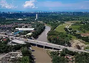
Carlos P. Garcia National Highway
The Carlos P. Garcia National Highway, also known as the Davao City Diversion Road, is a 18-kilometer (11 mi) two-to-six lane major highway that serves as a diversion route from the Davao city proper.[1] It also serves as one of the major roads in Davao when traversing towards Tagum.
| ||||
|---|---|---|---|---|
| Davao City Diversion Road | ||||
 Carlos P. Garcia National Highway and the Davao River Bridge | ||||
| Route information | ||||
| Maintained by the Department of Public Works and Highways | ||||
| Length | 18 km (11 mi) | |||
| Component highways | ||||
| Major junctions | ||||
| Northeast end | ||||
| ||||
| Southwest end | ||||
| Location | ||||
| Major cities | Davao City | |||
| Highway system | ||||
| ||||
Currently, the highway serves as the main diversion road for Davao City while the new bypass road is under construction.[2][3]
The highway is designated as National Route 913 (N913) of the Philippine highway network.
History
In 1955, Executive Order No. 113 was issued by former President Ramon Magsaysay, declaring the highway as a national secondary road.[4] It was declared a national secondary road due to the recommendation of the former National Transportation Board. Therefore, the highway is currently maintained by Department of Public Works and Highways as it was strengthened into a Department Order No. 90 in 1977.[5]
References
- "Davao City". www.dpwh.gov.ph. Retrieved 2018-11-24.
- Francisco, Carmelito Q. "P394-M Davao bypass road enters detailed engineering planning stage". BusinessWorld. Retrieved 24 November 2018.
- Colina IV, Antonio L. "Deals signed with China include infra projects for Davao, Marawi". MindaNews. Retrieved 24 November 2018.
- "Executive Order No. 113 s. 1955". Official Gazette PH. Retrieved 24 November 2018.
- "Department Order No. 90 S. 1977 PDF" (PDF). www.dpwh.gov.ph. Retrieved 24 November 2018.
.svg.png.webp)