Châteauneuf-Grasse
Châteauneuf-Grasse (alternative names are Châteauneuf de Grasse or simply Châteauneuf, known in Occitan as Castèunòu de Grassa) is a commune in the Alpes-Maritimes department in southeastern France.
Châteauneuf-Grasse | |
|---|---|
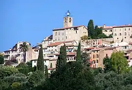 The clock tower of the church of Saint-Martin in Châteauneuf-Grasse | |
 Coat of arms | |
Location of Châteauneuf-Grasse 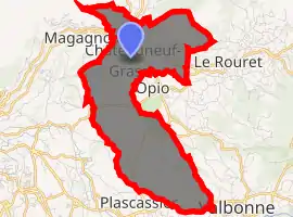
| |
 Châteauneuf-Grasse  Châteauneuf-Grasse | |
| Coordinates: 43°40′33″N 6°58′32″E | |
| Country | France |
| Region | Provence-Alpes-Côte d'Azur |
| Department | Alpes-Maritimes |
| Arrondissement | Grasse |
| Canton | Valbonne |
| Intercommunality | CA Sophia Antipolis |
| Government | |
| • Mayor (2008–2014) | Jean-Pierre Maurin (PR) |
| Area 1 | 8.95 km2 (3.46 sq mi) |
| Population (2017-01-01)[1] | 3,505 |
| • Density | 390/km2 (1,000/sq mi) |
| Time zone | UTC+01:00 (CET) |
| • Summer (DST) | UTC+02:00 (CEST) |
| INSEE/Postal code | 06038 /06740 |
| Elevation | 197–662 m (646–2,172 ft) |
| 1 French Land Register data, which excludes lakes, ponds, glaciers > 1 km2 (0.386 sq mi or 247 acres) and river estuaries. | |
Châteauneuf is situated on the French Riviera, just over 4 km from Grasse and 21 km (13 mi) from Cannes and borders the villages of Plascassier and Opio. Châteauneuf extends across 895 hectares and has a population of just over 3,000 inhabitants. It is divided into two districts: Pré-du-Lac, where most of the commerce is found, and Le Vignal.
Population
| Year | Pop. | ±% |
|---|---|---|
| 1982 | 2,128 | — |
| 1990 | 2,806 | +31.9% |
| 1999 | 2,968 | +5.8% |
| 2008 | 3,160 | +6.5% |
| 2016 | 3,364 | +6.5% |
Personalities
- Artist Marina Kulik lives and teaches in Châteauneuf.
- Calouste Gulbenkian lived and is buried in Châteauneuf.
- German actor Anton Diffring also lived and died in Châteauneuf. He was buried at White Colne in England.
- Harp maker Victor Salvi lived in Châteauneuf for several years.
References
- "Populations légales 2017". INSEE. Retrieved 6 January 2020.
External links
- (in French) Châteauneuf official website – general information
| Wikimedia Commons has media related to Châteauneuf-Grasse. |
| Authority control |
|---|
This article is issued from Wikipedia. The text is licensed under Creative Commons - Attribution - Sharealike. Additional terms may apply for the media files.