Chümoukedima
Chümoukedima is a census town in the Dimapur district of Nagaland state in India. It is at a distance of 14 km from Dimapur on National Highway 39.
Chümoukedima | |
|---|---|
Town and sub-division | |
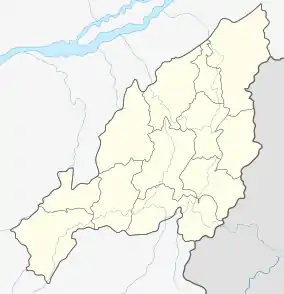 Chümoukedima Location in Nagaland, India | |
| Coordinates: 25.7916°N 93.7818°E | |
| Country | |
| State | Nagaland |
| District | Dimapur |
| Population (2001) | |
| • Total | 16,510 |
| Languages | |
| • Official | English |
| Time zone | UTC+5:30 (IST) |
| Vehicle registration | NL |
| Website | nagaland |
History
It served as the first headquarters of the then Naga Hills District of Assam during the time of British rule in early 19th century. The town was also called Nechu Guard and also as Samaguting during World War II.
Demographics
As of 2001 India census,[1] Chümoukedima had a population of 16,510. Males constitute 52% of the population and females 48%. Chümoukedima has an average literacy rate of 69%, higher than the national average of 59.5%: male literacy is 73% and, female literacy is 65%. In Chümoukedima, 17% of the population is under 6 years of age.
Economy
Chümoukedima is one of the fastest growing towns in Nagaland. In fact, it forms part of the Dimapur–Chümoukedima urban area which is the largest and the fastest growing urban hub of Nagaland. The town's population has grown by nearly five times in the last two decades.
Geography
It is located in the foothills of Naga Hills. The Tourist Village on the top of a hill projects a bird's eye view the whole of Dimapur and other parts of Karbi Anglong district of Assam. Waterfalls are also located in this area.
References
- "Census of India 2001: Data from the 2001 Census, including cities, villages and towns (Provisional)". Census Commission of India. Archived from the original on 16 June 2004. Retrieved 1 November 2008.
