Naga Hills
The Naga Hills, reaching a height of around 3,825 metres (12,549 ft), lie on the border of India and Burma (Myanmar). They are part of a complex mountain system, and the parts of the mountain ranges inside the Indian state of Nagaland and the Burmese Naga Self-Administered Zone are called the Naga Hills. The highest point of the Naga hills is Mount Saramati (3826 m).
| Naga Hills | |
|---|---|
| Highest point | |
| Peak | Mount Saramati |
| Elevation | 3,827 m (12,556 ft) |
| Geography | |
| Countries | India and Burma |
| Range coordinates | 26°N 95°E |
Etymology
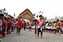
The term "Naga" refers to the Naga people, who were called "Naga" or "Naka" in the Burmese language, meaning "people with pierced ears".[1]
History
In British India, the major part of the hills came under the Naga Hills District. A part of the Naga Hills under the British India control was coalesced into a district in 1866.[2] The boundaries of the Naga Hills District were gradually expanded by annexation of the territories of several Naga tribes, including the Aos (1889), the Semas (1904) and the Konyaks (1910). In 1912, the district was made part of Assam province. Following the Partition of India, it was merged with the Tuensang Division to create the state called Nagaland in 1963.[3]
Geology: national geological monument
Nagahill Ophiolite Site near Pungro in Kiphire district of Nagaland has been declared a National Geological Monument of India by the Geological Survey of India (GSI), for their protection, maintenance, promotion and enhancement of geotourism.[4][5][6] The Naga Hills, due to their complexity and position, forms a natural barrier between the two countries. The Naga Hills are part of the Arakan Range (Rakhine Range), which to the north rise to 12,552 feet.
See also
Notes
- Shimray, R. R. (1985), Origin and Culture of Nagas, Pamleiphi Shimray, New Delhi, page 41, OCLC 14819323
- Inato Yekheto Shikhu (2007). A Re-discovery and Re-building of Naga Cultural Values. Daya Books. pp. 53–55. ISBN 978-81-89233-55-6.
- B. Datta-Ray, S. P. Agrawal (1996). Reorganization of North-East India since 1947. Concept. p. 6. ISBN 978-81-7022-577-5.
- "National Geological Monument, from Geological Survey of India website". Archived from the original on 12 July 2017. Retrieved 21 January 2019.
- "Geo-Heritage Sites". pib.nic.in. Press Information Bureau. 9 March 2016. Retrieved 15 September 2018.
- national geo-heritage of India, INTACH
