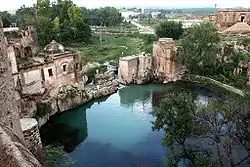
Chakwal District
Chakwal District (Punjabi, Urdu: ضِلع چکوال) is in Pothohar Plateau of Punjab, Pakistan. It is located in the north of the Punjab province, Chakwal district is bordered by Khushab to its south, Rawalpindi to its north east, Jhelum to its east, Mianwali to its west and Attock to its north west. The district was created out of parts of Jhelum and Attock in 1985.[3]
Chakwal
ضِلع چکوال | |
|---|---|
 | |
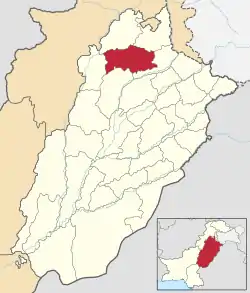 Chakwal is located in the north of Punjab. | |
| Coordinates: 33°40′38″N 72°51′21″E | |
| Country | Pakistan |
| Province | Punjab |
| Headquarters | Chakwal |
| Tehsils (5) | |
| Government | |
| • Chairman of District Council | Muhammad Tariq Awan (PML N) |
| • Members of National Assembly | Sardar Zulfiqar Ali Khan (NA-64) Ch Parvez Ilahi (NA-65)[1] |
| • Members of Provincial Assembly | Raja Yasir Humayun(PP-21) Tanveer Aslam Malik (PP-22) Sardar Aftab Ali Khan (PP-23) Hafiz Ammar Yasir([PP-24) |
| Area | |
| • Total | 6,524 km2 (2,519 sq mi) |
| Population (2017)[2] | |
| • Total | 1,495,982 |
| • Density | 230/km2 (590/sq mi) |
| Time zone | UTC+5 (PST) |
| Main language(s) | Punjabi, Dhani |
History
During British rule, Chakwal was a tehsil of Jhelum district, the population according to the 1891 census of India was 164,912 which had fallen to 160,316 in 1901. It contained the towns of Chakwal and Bhaun and 248 villages. The land revenue and cesses amounted in 1903-4 to 3–300,000.[4] The predominantly Muslim population supported Muslim League and Pakistan Movement. After the independence of Pakistan in 1947, the minority Hindus and Sikhs migrated to India while the Muslims refugees from India settled down in the Chakwal District.
Administrative divisions
The district of Chakwal, which covers an area of 6,524 km²,[5] is subdivided into five tehsils.[6] These tehsils were formerly part of neighbouring districts:[7]:1
- Chakwal Tehsil was annexed from Jhelum District and made part of newly formed Chakwal District.
- Talagang Tehsil was annexed from Attock District and was made second sub-division of Chakwal District.
- Choa Saidan Shah was carved out of sub-division Pind Dadan Khan of Jhelum District and was amalgamated with sub-division Chakwal. Choa Saidan Shah was upgraded to the level of a sub-division in 1993.
The district is administratively subdivided into five tehsils and 68 union councils.[8]
| Name of tehsil | No. of union councils | No. of villages | No. of public schools | No. of police stations | No. of post offices |
|---|---|---|---|---|---|
| Chakwal | 30 | 207 | 523 | 5 | 48 |
| Kallar Kahar | 8 | 72 | 148 | 1 | 15 |
| Choa Saidan Shah | 7 | 47 | 96 | 1 | 14 |
| Talagang | 17 | 76 | 318 | 3 | 30 |
| Lawa | 6 | 18 | 119 | 1 | 11 |
| Total | 68 | 420 | 1204 | 11 | 118 |
Constituencies
There is one district council, two municipal committees — Chakwal and Talagang — and two town committees — Choa Saidan Shah and Kallar Kahar.
The district is represented in the National Assembly by two constituencies: NA-60 and NA-61. The district is represented in the provincial assembly by four elected MPAs and in National Assembly by two MNAs who represent the following constituencies:[9]
| Constituency | MPA | Party |
|---|---|---|
| (PP-21) | Raja Yasir Hamayun Sarfaraz | Pakistan Tehreek Insaf [10] |
| (PP-22) | Tanveer Aslam Malik | Pakistan Muslim League (N) |
| (PP-23) | Sardar Aftab Khan | Pakistan Tehreek Insaf |
| (PP-24) | Ammar Yasir | Pakistan Muslim League (Q) |
| (NA-64) | Sardar Zulfiqar Ali Khan | Pakistan Tehreek Insaf |
| (NA-65) | Choudari Perwaiz Ilahi | Pakistan Muslim League (Q)[1] |
Geography
Chakwal district borders the districts of Rawalpindi and Attock in the north, Jhelum in the east, Khushab in the south and Mianwali in the west. The total area of Chakwal district is 6,609 square kilometres, which is equivalent to 1,652,443 acres (6,687.20 km2).
The southern portion runs up into the Salt Range, and includes the Chail peak, 3,701 feet (1,128 m) above the sea, the highest point in the district. Between this and the Sohan river, which follows more or less the northern boundary, the country consists of what was once a fairly level plain, sloping down from 2,000 feet (610 m) at the foot of the hills to 1,400 feet (430 m) in the neighbourhood of the Sohan; the surface is now much cut up by ravines and is very difficult to travel over.[4]
Demography
According to the 1998 census of Pakistan, the total population is 1,083,725 of which only 12.01% were urban — making Chakwal the most rural district in Punjab.[11] The literacy rate in 1998 was 57%.[12]
According to the 1998 census, the predominant first language[13] of the district is Punjabi, spoken by 97.7% of the population. Pashto is the first language of 1.2%, and Urdu – of 0.9%.[7]:23 The local Punjabi dialects are Dhani[14] and Awankari.[15]
Education
Chakwal has a total of 1,199 government schools out of which 52 percent (627 schools) are for female students. The district has an enrollment of 181,574 in public sector schools.[16]
Educational institutions
Educational institutions in the Chakwal District include:
- Kallar Kahar Science Colleges for Boys, Kallar Kahar, Malhal Mughlan, Choa Saidan Shah, Buchhal Kalan
- Kallar Kahar Science Colleges for Girls, Kallar Kahar, Chakwal, Choa Saidan Shah, Danda Shah Bilawal, Buchal Kalan
- Government Post Graduate College (Chakwal)
- Cadet College Kallar Kahar
- Mayers Colles Kot Sarfaraz Chakwal City
- UET Taxila Sub Campus Chakwal
- Cadet College Choa Saidan Shah
- Cadet College Chakwal
- PAF College Kallar Kahar
- Horizon College Chakwal
- Hiraz Girls College Chakwal
- Chakwal Homeopethic College
- Cambridge International Science College Talagang
See also
Notable people
- Yahya Khan, former President of Pakistan, was born at Chakwal city on 1917.
- Manmohan Singh, former Prime Minister of India, was born in Gah village then part of Jhelum District
- Khudadad Khan, VC, British Indian Army.
- Malik Nur Khan, Nur Khan, was a three-star air officer, politician, sports administrator, and the Commander-in-Chief of the Pakistan Air Force, serving under President Ayub Khan from 1965 until 1969.
- Muhammad Safdar, Lt. General Muhammad Safdar is the former Governor of Punjab, having served from 1999 to 2001. He has previously also served as the ambassador to Morocco and the Vice Chancellor of the University of the Punjab till 1993.
- Colonel Imam – Brigadier Sultan Amir Tarar was a one-star rank army general in the Pakistan Army, member of Special Service Group (SSG) of the army and an intelligence officer of the Inter-Services Intelligence (ISI).
References
- Chakwal district falls into PML-N’s fold, retrieved 17 September 2015
- "DISTRICT WISE CENSUS RESULTS CENSUS 2017" (PDF). www.pbscensus.gov.pk. Archived from the original (PDF) on 29 August 2017. Retrieved 3 September 2017.
- "Chakwal – Punjab Portal". Retrieved 17 December 2016.
- Imperial Gazetteer of India, v. 10, p. 126. Dsal.uchicago.edu. Retrieved on 21 April 2012.
- Official Website of Chakwal District Archived 3 July 2009 at the Wayback Machine
- List to tehsils and districts Archived 1 January 2007 at the Wayback Machine
- 1998 District Census report of Chakwal. Census publication. 77. Islamabad: Population Census Organization, Statistics Division, Government of Pakistan. 2000.
- Tehsils & Unions in the District of Chakwal Archived 24 January 2008 at the Wayback Machine. Nrb.gov.pk. Retrieved on 21 April 2012.
- CHAKWAL (PP-20 to PP-23) – Website of the Provincial Assembly of the Punjab
- "PML-N wins Chakwal by-polls with thumping majority". Retrieved 8 March 2018.
- 1998 Census figures – Urban Resource Centre
- "Districts at a glance – Chakwal". Retrieved 17 December 2016.
- "Mother tongue": defined as the language of communication between parents and children, and recorded of each individual.
- Masica, Colon P. (9 September 1993). The Indo-Aryan Languages. Cambridge University Press. p. 19. ISBN 0521299446.
- Rensch, Calvin R. (1992). "The Language Environment of Hindko-Speaking People". In O'Leary, Clare F.; Rensch, Calvin R.; Hallberg, Calinda E. (eds.). Hindko and Gujari. Sociolinguistic Survey of Northern Pakistan. Islamabad: National Institute of Pakistan Studies, Quaid-i-Azam University and Summer Institute of Linguistics. p. 7. ISBN 969-8023-13-5.
- "Punjab Annual Schools Census Data 2014-15". Archived from the original on 22 August 2016. Retrieved 22 August 2016.
Bibliography
- University of Engineering and Technology. Centre of Excellence in Water Resources Engineering; Pakistan Science Foundation (1979), National Seminar on Land and Water Resources Development of Barani Areas, [July 21-24, 1979], The University of Wisconsin, ISBN 978-01-9023-806-3
External links
| Wikivoyage has a travel guide for Punjab (Pakistan). |
Places adjacent to Chakwal District | ||||||||||
|---|---|---|---|---|---|---|---|---|---|---|
| ||||||||||
Provincial capital: Lahore | ||
| Divisions | Districts |  |
| Bahawalpur | ||
| Dera Ghazi Khan | ||
| Faisalabad | ||
| Gujranwala | ||
| Lahore | ||
| Multan | ||
| Rawalpindi | ||
| Sahiwal | ||
| Sargodha | ||