Chalus, Iran
Chalus (Persian: چالوس, also romanized as Chālūs, Chaloos, Chalousse, Chalous, and Čālūs)[2][3] is a city in Mazandaran Province in north of Iran. It serves as the county seat for Chalus County. According to the 2006 census, it has a population of 44,618, in 12,791 families.[4] Chalus is a major vacation destination for Iranians during holidays for its nice weather and natural attractions. The people residing in Chalus speak Mazanderani language. In the west of Chalus, the dialect of Kalarestaqi is spoken and in the east of Chalus, the dialect of Kojuri.[5] [6] What is more, one of the great attractions of Chalus is the road leading to Chalus, widely known as Chalus Road. This attractive city with its delightful attractions has a great reputation for a number of magnificent villages, one of which is called Shahrak-e Namak Abrud. This village offers a variety of different entertaining activities, such as cable car, offering a fantastic view of the surrounding mountains.
Chalus
چالوس | |
|---|---|
City | |
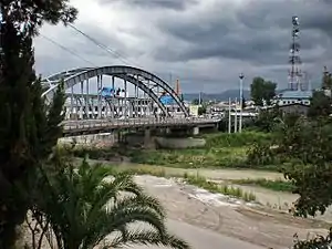 Chalus on Chalus River with "Pol-e Ahani (Iron Bridge)" | |
 Seal | |
 | |
 Chalus | |
| Coordinates: 36°39′18″N 51°25′13″E | |
| Country | |
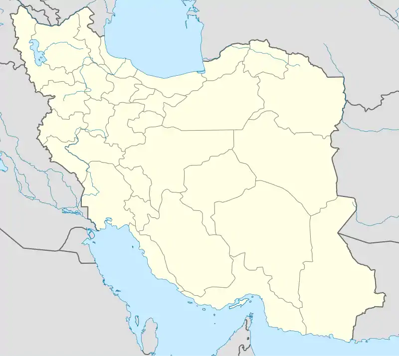
| Province | Mazandaran |
| County | Chalus |
| Bakhsh | Central |
| Government | |
| • Type | Mayor, City Council |
| • Mayor | Jafar Shams |
| • Representative in Majles | Ghasem Ahmadi Lashaki |
| Population (2016 Census) | |
| • Total | 65,196 [1] |
| Time zone | UTC+3:30 (IRST) |
| • Summer (DST) | UTC+4:30 (IRDT) |
| Website | http://www.chalouscity.ir/ |
Location
The bordering counties are Noshahr to the east, Tonekabon to the west in Mazandaran province and Tehran province to the south. It sits on the Chalus River by the Caspian.
History
Chalus used to be called "Salus" or "Shalus". It has a long history of rebels and fights with regional rulers or occupying foreign forces. Chalus used to have a big silk factory that was active from 1936 to 1958 and exported fabrics and other silk products to different countries.
Chalus is part of the Kalarestaq area and Kalarestaq is part of Ruyan.
Ruyan is a land in the west of Mazandaran Province, Iran. This land includes Kojur, Kalārestāq and Tonekabon.
The city of Kojur was the centre of the land of the Ruyans. Ruyan has always been part of the Tabaristan, nowadays called Mazandaran province. The Ruyan was also called the Rostamdār, Ostandār and Rostamdele.[7]
Main Sights
Gole Sorkhi, Kaakh (The Palace), Chalus Mahalleh, Radyo Darya, Dahgiri, Sheykh Ghotb are among the most notable neighborhoods of Chalus.
References
- https://www.amar.org.ir/english
- Chalus, Iran can be found at GEOnet Names Server, at this link, by opening the Advanced Search box, entering "-3057857" in the "Unique Feature Id" form, and clicking on "Search Database".
- "ČĀLŪS – Encyclopaedia Iranica". www.iranicaonline.org. Retrieved 2019-01-22.
- "Census of the Islamic Republic of Iran, 1385 (2006)". Islamic Republic of Iran. Archived from the original (Excel) on 2011-11-11.
- http://www.iranicaonline.org/articles/kalarestaq-1
- http://www.iranicaonline.org/articles/kojur-i
- "KALĀRESTĀQ i. The District and Sub-District". Encyclopaedia Iranica. Retrieved 2019-09-26.
| Map of central Alborz | Peaks: | 1 Alam-Kuh |
|---|---|---|
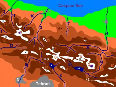 −25 to 500 m (−82 to 1,640 ft) 500 to 1,500 m (1,600 to 4,900 ft) 1,500 to 2,500 m (4,900 to 8,200 ft) 2,500 to 3,500 m (8,200 to 11,500 ft) 3,500 to 4,500 m (11,500 to 14,800 ft) 4,500 to 5,671 m (14,764 to 18,606 ft) |
2 Azad Kuh | 3 Damavand |
| 4 Do Berar | 5 Do Khaharan | |
| 6 Ghal'eh Gardan | 7 Gorg | |
| 8 Kholeno | 9 Mehr Chal | |
| 10 Mishineh Marg | 11 Naz | |
| 12 Shah Alborz | 13 Sialan | |
| 14 Tochal | 15 Varavašt | |
| Rivers: | 0 | |
| 1 Alamut | 2 Chalus | |
| 3 Do Hezar | 4 Haraz | |
| 5 Jajrood | 6 Karaj | |
| 7 Kojoor | 8 Lar | |
| 9 Noor | 10 Sardab | |
| 11 Seh Hazar | 12 Shahrood | |
| Cities: | 1 Amol | |
| 2 Chalus | 3 Karaj | |
| Other: | D Dizin | |
| E Emamzadeh Hashem | K Kandovan Tunnel | |
| * Latyan Dam | ** Lar Dam |
| Capital | |
|---|---|
| Counties and cities | |
| Sights | 
|
| populated places | |