Shah Alborz
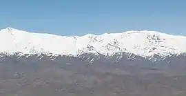
Shah Alborz is a mountain peak in Alborz range in Iran. At an elevation of 4,200 metres (13,800 ft)[1] it is the highest peak in the range. Its north face rises from the Alamout valley, to the south lies the Taleghan Valley and to the west, the plains of east-Ghazvin. Parts of the north face are covered by the Shah Alborz glacier at elevations of 3,400 to 3,600 metres (11,200 to 11,800 ft).[2]
| Map of central Alborz | Peaks: | 1 Alam-Kuh |
|---|---|---|
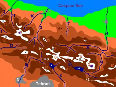 −25 to 500 m (−82 to 1,640 ft) 500 to 1,500 m (1,600 to 4,900 ft) 1,500 to 2,500 m (4,900 to 8,200 ft) 2,500 to 3,500 m (8,200 to 11,500 ft) 3,500 to 4,500 m (11,500 to 14,800 ft) 4,500 to 5,671 m (14,764 to 18,606 ft) |
2 Azad Kuh | 3 Damavand |
| 4 Do Berar | 5 Do Khaharan | |
| 6 Ghal'eh Gardan | 7 Gorg | |
| 8 Kholeno | 9 Mehr Chal | |
| 10 Mishineh Marg | 11 Naz | |
| 12 Shah Alborz | 13 Sialan | |
| 14 Tochal | 15 Varavašt | |
| Rivers: | 0 | |
| 1 Alamut | 2 Chalus | |
| 3 Do Hezar | 4 Haraz | |
| 5 Jajrood | 6 Karaj | |
| 7 Kojoor | 8 Lar | |
| 9 Noor | 10 Sardab | |
| 11 Seh Hazar | 12 Shahrood | |
| Cities: | 1 Amol | |
| 2 Chalus | 3 Karaj | |
| Other: | D Dizin | |
| E Emamzadeh Hashem | K Kandovan Tunnel | |
| * Latyan Dam | ** Lar Dam |
| Shah Alborz | |
|---|---|
 | |
| Highest point | |
| Elevation | 4,200 m (13,800 ft) |
| Coordinates | 36°19′N 50°45′E |
| Geography | |
 Shah Alborz | |
| Parent range | Alborz |

Climbing
The level of difficulty is "walk-up" and the nearest center is Taleghan. The best months to climb the mountain are from March to September.[1] The most often-used route to the peak passes through the Hasanjoon valley.[3]
References
- "Shah Alborz". Peakware World Mountain Encyclopedia. Interactive Outdoors, Inc. Retrieved 2007-07-31.
- nomad. "Shah Alborz (King Alborz)". SummitPost.org. Retrieved 2007-07-31.
- "Mount Shah Alborz". MountainZone.ir. Archived from the original on 2007-07-10. Retrieved 2007-07-31.
This article is issued from Wikipedia. The text is licensed under Creative Commons - Attribution - Sharealike. Additional terms may apply for the media files.