Kholeno
Kholeno or Koleh-no (Persian: خلنو and خله نو) is a mountain in Kholeno/Azadkouh massif in central Alborz range located in North of Iran. It is located in Tehran province very close to the border of Mazandaran Province. Typical ascending path to Kholeno is its south face starting from Lalan, Tehran village.[1]
| Kholeno | |
|---|---|
 Kholeno Location in Iran | |
| Highest point | |
| Elevation | 4,375 m (14,354 ft) |
| Coordinates | 36°3′53″N 51°33′7″E |
| Geography | |
| Location | Tehran, Iran |
| Parent range | Alborz |
| Climbing | |
| Easiest route | South face via Lalan, Tehran village |
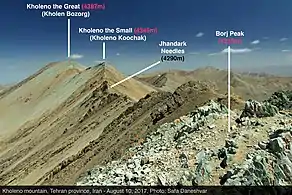
Kholeno region and summits, Tehran Province, Iran
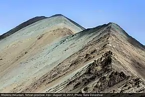
Kholeno Summit, Tehran Province, Iran
Ascent in winter is difficult from its South face due to avalanches.
Kholeno has two summits which the tallest 4375 m peak located at the north of the other with 4348 meters height. There is a dispute about Kholeno and Azadkouh, another mountain in the region with very close height, which one is taller.[2]
| Map of central Alborz | Peaks: | 1 Alam-Kuh |
|---|---|---|
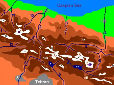 −25 to 500 m (−82 to 1,640 ft) 500 to 1,500 m (1,600 to 4,900 ft) 1,500 to 2,500 m (4,900 to 8,200 ft) 2,500 to 3,500 m (8,200 to 11,500 ft) 3,500 to 4,500 m (11,500 to 14,800 ft) 4,500 to 5,671 m (14,764 to 18,606 ft) |
2 Azad Kuh | 3 Damavand |
| 4 Do Berar | 5 Do Khaharan | |
| 6 Ghal'eh Gardan | 7 Gorg | |
| 8 Kholeno | 9 Mehr Chal | |
| 10 Mishineh Marg | 11 Naz | |
| 12 Shah Alborz | 13 Sialan | |
| 14 Tochal | 15 Varavašt | |
| Rivers: | 0 | |
| 1 Alamut | 2 Chalus | |
| 3 Do Hezar | 4 Haraz | |
| 5 Jajrood | 6 Karaj | |
| 7 Kojoor | 8 Lar | |
| 9 Noor | 10 Sardab | |
| 11 Seh Hazar | 12 Shahrood | |
| Cities: | 1 Amol | |
| 2 Chalus | 3 Karaj | |
| Other: | D Dizin | |
| E Emamzadeh Hashem | K Kandovan Tunnel | |
| * Latyan Dam | ** Lar Dam |
References
- https://www.google.com/maps?q=lalan&hl=en&ll=35.993702,51.577463&spn=0.020312,0.042272&sll=35.985785,51.586819&sspn=0.020314,0.042272&t=p&hnear=Lalan,+Tehran,+Iran&z=15
- "Kholeno". Summitpost.org. Retrieved September 17, 2006.
This article is issued from Wikipedia. The text is licensed under Creative Commons - Attribution - Sharealike. Additional terms may apply for the media files.
