Changdao County
The Changdao County simplified Chinese: 长岛县; traditional Chinese: 長島縣; pinyin: Chángdǎo Xiàn; lit. 'long island county') is a county in Yantai, a prefectural area of Shandong in the People's Republic of China. It consists of the Changshan Islands within the Bohai Strait, directly north of Penglai. They are known for their sandy beaches and picturesque limestone cliffs.[1] The total land area is only 56 square kilometers (22 sq mi), but the coastline is 146 km (91 mi) long.
Changdao County
长岛县 | |
|---|---|
 A view of South Changshan Island (南长山岛), the largest of the Changdao Islands | |
 Location in Yantai | |
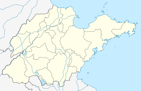 Changdao Location in Shandong | |
| Coordinates: 37°54′45″N 120°41′59″E | |
| Country | People's Republic of China |
| Province | Shandong |
| Prefecture-level city | Yantai |
| Government | |
| • Head of County | Zhang Yanting (张延廷) |
| Area | |
| • Total | 56 km2 (22 sq mi) |
| Highest elevation | 202.8 m (665.4 ft) |
| Population | |
| • Total | 43,000 |
| • Density | 770/km2 (2,000/sq mi) |
| Time zone | UTC+8 (China Standard) |
| Postal code | 265800 |
| Area code(s) | 535 |
| Website | www.changdao.gov.cn |
Geography
The Changshan Islands (simplified Chinese: 长山列岛; traditional Chinese: 長山列島; pinyin: Chángshān lièdǎo), also known as the Temple Islands or Miaodao Archipelago (庙岛群岛; 廟島群島; Miàodǎo qúndǎo) are an archipelago of 32 islands located across the southern portion of the Bohai Strait, the waterway connecting the Bohai Sea to the Yellow Sea, collectively named after the two largest islands. In Chinese, they are also known as the "Long Islands" (长岛; 長島; Chángdǎo), and anciently as the "Sandy Gate Islands" (沙门岛; 沙門島; Shāmén dǎo).
Administrative Divisions
The Changdao County has jurisdiction over one subdistrict, one town and six townships:[2]
- Nanchangshan Subdistrict 南长山街道 South Changshan Subdistrict
- Tuojizhen Town 砣矶镇
- Beichangshan Township 北长山乡 North Chang Mountain Township
- Heishan Township 黑山乡 (Black Mountain Township)
- Daqindao Township 大钦岛乡 (Greater Qin Island Township)
- Xiaoqindao Township 小钦岛乡 (Lesser Qin Island Township)
- Nanhuangcheng Township 南隍城乡 (South Huangcheng Township)
- Beihuangcheng Township 北隍城乡 (North Huangcheng Township)
Islands
There are 32 islands in Changshan Islands, and 10 of them have permanent residential settlements. These islands are mostly formed by Proterozoic low-grade metamorphic rocks, with smaller amounts of Tertiary igneous rocks and Quaternary sedimentary rocks.
| Name | Chinese Name | Length (km) | Width (km) | Area (km2) | Shoreline (km) | Maximum elevation (m) |
|---|---|---|---|---|---|---|
| South Changshan Island | 南长山岛 | 7.22 | 4 | 12.8 | 20.02 | 156.1 |
| North Changshan Islands | 北长山岛 | 5.1 | 2.6 | 7.87 | 13.8 | 195.7 |
| Greater Heishan Island | 大黑山岛 | 4.22 | 2.7 | 7.47 | 12.03 | 189 |
| Lesser Heishan Island | 小黑山岛 | 1.9 | 0.85 | 1.29 | 5.3 | 95.1 |
| Miao Island (Temple Island) | 庙岛 | 2.65 | 1.1 | 1.43 | 6.7 | 98.3 |
| Tuoji Island | 砣矶岛 | 4.75 | 3.9 | 7.05 | 17.68 | 198.9 |
| Greater Qin Island | 大钦岛 | 4.9 | 2 | 6.44 | 14.55 | 202.44 |
| Lesser Qin Island | 小钦岛 | 2 | 0.85 | 1.11 | 6.44 | 148.9 |
| South Huangcheng Island | 南隍城岛 | 3.1 | 1.6 | 1.83 | 12.09 | 100.9 |
| North Huangcheng Island | 北隍城岛 | 2.85 | 1.9 | 2.62 | 10.32 | 159.8 |
| Yulin Island (Fish Scales Island) | 鱼鳞岛 | 0.17 | 0.1 | 0.01 | 0.38 | 19.5 |
| South Tuozi Island | 南砣子岛 | 0.86 | 0.4 | 0.138 | 2.31 | 15.1 |
| Niutuozi Island (Ox Rocky Island) | 牛砣子岛 | 0.55 | 0.35 | 0.11 | 1.38 | 26.4 |
| Yangtuozi Island (Goat Rocky Island) | 羊砣子岛 | 0.55 | 0.35 | 0.11 | 1.38 | 26.4 |
| Shaobing Island (Pancake Island) | 烧饼岛 | 0.14 | 0.1 | 0.02 | 0.38 | 19.6 |
| Lijupa Island | 犁犋把岛 | 0.19 | 0.08 | 0.01 | 0.4 | 22.4 |
| Xie Island (Scorpins Island) | 蝎岛 | 0.1 | 0.045 | 0.004 | 0.21 | 9.8 |
| Houji Island | 猴矶岛 | 1.1 | 0.47 | 0.28 | 2.75 | 92.9 |
| Lesser Houji Island | 小猴矶岛 | 0.04 | 0.025 | 0.0009 | 0.22 | 23.3 |
| Gaoshan Island | 高山岛 | 1.3 | 0.7 | 0.46 | 3.55 | 202.8 |
| Lesser Gaoshan Island | 小高山岛 | 0.035 | 0.025 | 0.0008 | 0.22 | 12.6 |
| Greater Zhushan Island | 大竹山岛 | 2.1 | 1.2 | 1.49 | 5.2 | 194.5 |
| Lesser Zhushan Island | 小竹山岛 | 0.8 | 0.4 | 0.24 | 2 | 97.2 |
| Cheyou Island | 车由岛 | 0.64 | 0.1 | 0.05 | 1.25 | 73.5 |
| Tuozi Island | 砣子岛 | 0.42 | 0.15 | 0.05 | 1.06 | 60.3 |
| Dongzuishi Island | 东嘴石岛 | 0.05 | 0.04 | 0.002 | 0.15 | 7.2 |
| Shanzuishi Island | 山嘴石岛 | 0.065 | 0.02 | 0.0013 | 0.17 | 16.7 |
| Biegaishan Island (Turtle Shell Mount Island) | 鳖盖山岛 | 0.2 | 0.11 | 0.02 | 0.57 | 42.8 |
| Pojiao Island | 坡礁岛 | 0.085 | 0.02 | 0.0017 | 0.15 | 12 |
| Tanglang Island (Mantis Island) | 螳螂岛 | 0.97 | 0.25 | 0.15 | 2.01 | 54.7 |
| Danglang Island (Wave Breaking Island) | 挡浪岛 | 0.5 | 0.4 | 0.13 | 1.86 | 35.9 |
| Maqiangshi Island | 马枪石岛 | 0.1 | 0.016 | 0.0015 | 0.14 | 8.9 |
Demographics
Ten of the islands are occupied, and there are twenty-two uninhabited islands, some little more than sand spits. There is one large town, Tuoji Town (砣矶镇, population 8,495) and seven smaller towns with forty villages, with a total population in the county of 52,000.
Economy
The major occupation is aquaculture, producing products such as sea cucumbers, abalone, sea urchins, bivalves, kelp, scallops, prawns and fish. Tourism is also important; many of the villages sport resort hotels.
Transportation
The islands are regularly served by both a passenger and vehicle Roll On, Roll Off ferry from Penglai. There is a small military airport on the largest island, South Changshan Island.
Tourism
Both Changdao National Forest Park and Changdao National Nature Reserve are located on the islands, which are on a cross-Bohai Sea flyway.
Temple Island (庙岛; 廟島; Miàodǎo) got its name from the large number of temples that were built there. Xianying Palace is a temple that was built during the Northern Song Dynasty, starting in 1122. It was originally a Taoist temple to the sea goddess Matsu, but became Buddhist later. At the present time the local government has restored the temple to its Ming Dynasty appearance, although many additions had been made during the Qing.
Changdao Island was previously closed to non-Chinese nationals. Westerners found on the island were swiftly taken to the passenger ferry terminal and placed on the next ferry back to Penglai by the islands Police service. Islanders promptly reported all "outsiders" to the islands police service. Police explained the reasons for this was due to the high number of military installations on the Island. The Changdao Islands are now open to non-Chinese nationals, including westerners. This was agreed by the local and national governments as of 1 December 2008.
References
External links
- Official Changdao County website
- Changdao website from Yantai IDB development corporation (in Chinese)
| Authority control |
|---|