Chapeauroux
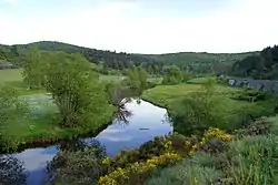
The Chapeauroux (French: le Chapeauroux) is a 56.1-kilometre (34.9 mi) long river in the Lozère and Haute-Loire départements, south-central France.[1] Its source is near Estables, in the Margeride. It flows generally northeast. It is a left tributary of the Allier into which it flows between Saint-Bonnet-de-Montauroux and Saint-Christophe-d'Allier.
| Chapeauroux | |
|---|---|
 | |
| Location | |
| Country | France |
| Physical characteristics | |
| Source | |
| • location | Estables |
| • coordinates | 44°39′51″N 03°32′34″E |
| • elevation | 1,460 m (4,790 ft) |
| Mouth | |
• location | Allier |
• coordinates | 44°50′23″N 03°44′07″E |
• elevation | 740 m (2,430 ft) |
| Length | 56.1 km (34.9 mi) |
| Basin size | 387 km2 (149 sq mi) |
| Discharge | |
| • average | 3.36 m3/s (119 cu ft/s) |
| Basin features | |
| Progression | Allier→ Loire→ Atlantic Ocean |
Départements and communes along its course
This list is ordered from source to mouth:
Notes
- This article is based on the fr:Chapeauroux from the French Wikipedia, consulted on March 23rd 2009.
References
This article is issued from Wikipedia. The text is licensed under Creative Commons - Attribution - Sharealike. Additional terms may apply for the media files.
