Arzenc-de-Randon
Arzenc-de-Randon is a commune in the Lozère department in southern France.
Arzenc-de-Randon | |
|---|---|
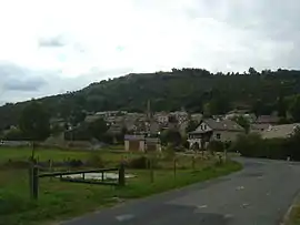 A general view of the village of Arzenc-de-Randon | |
 Coat of arms | |
Location of Arzenc-de-Randon 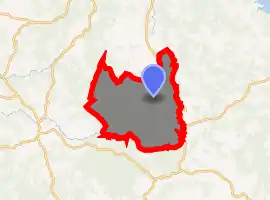
| |
 Arzenc-de-Randon  Arzenc-de-Randon | |
| Coordinates: 44°39′45″N 3°37′58″E | |
| Country | France |
| Region | Occitanie |
| Department | Lozère |
| Arrondissement | Mende |
| Canton | Grandrieu |
| Intercommunality | CC Randon-Margeride |
| Government | |
| • Mayor (2014-2020) | Francis Gibert |
| Area 1 | 69.20 km2 (26.72 sq mi) |
| Population (2017-01-01)[1] | 200 |
| • Density | 2.9/km2 (7.5/sq mi) |
| Time zone | UTC+01:00 (CET) |
| • Summer (DST) | UTC+02:00 (CEST) |
| INSEE/Postal code | 48008 /48170 |
| Elevation | 1,146–1,542 m (3,760–5,059 ft) (avg. 1,189 m or 3,901 ft) |
| 1 French Land Register data, which excludes lakes, ponds, glaciers > 1 km2 (0.386 sq mi or 247 acres) and river estuaries. | |
Geography
The Chapeauroux flows east through the middle of the commune.
The Colagne has its source in the commune; with the Lac de Charpal they form most of the commune's southwestern border.
Population
| Year | Pop. | ±% |
|---|---|---|
| 1793 | 750 | — |
| 1800 | 625 | −16.7% |
| 1806 | 826 | +32.2% |
| 1821 | 658 | −20.3% |
| 1831 | 821 | +24.8% |
| 1836 | 811 | −1.2% |
| 1841 | 762 | −6.0% |
| 1846 | 808 | +6.0% |
| 1851 | 761 | −5.8% |
| 1856 | 750 | −1.4% |
| 1861 | 820 | +9.3% |
| 1866 | 829 | +1.1% |
| 1872 | 762 | −8.1% |
| 1876 | 821 | +7.7% |
| 1881 | 903 | +10.0% |
| 1886 | 825 | −8.6% |
| 1891 | 855 | +3.6% |
| 1896 | 901 | +5.4% |
| 1901 | 917 | +1.8% |
| 1906 | 889 | −3.1% |
| 1911 | 883 | −0.7% |
| 1921 | 761 | −13.8% |
| 1926 | 749 | −1.6% |
| 1931 | 668 | −10.8% |
| 1936 | 593 | −11.2% |
| 1946 | 476 | −19.7% |
| 1954 | 425 | −10.7% |
| 1962 | 412 | −3.1% |
| 1968 | 374 | −9.2% |
| 1975 | 300 | −19.8% |
| 1982 | 240 | −20.0% |
| 1990 | 180 | −25.0% |
| 1999 | 195 | +8.3% |
| 2007 | 206 | +5.6% |
| 2009 | 208 | +1.0% |
| 2015 | 213 | +2.4% |
See also
References
- "Populations légales 2017". INSEE. Retrieved 6 January 2020.
| Wikimedia Commons has media related to Arzenc-de-Randon. |
| Authority control |
|---|
This article is issued from Wikipedia. The text is licensed under Creative Commons - Attribution - Sharealike. Additional terms may apply for the media files.