Châteauneuf-de-Randon
Châteauneuf-de-Randon (French pronunciation: [ʃatonœf də ʁɑ̃dɔ̃]; Occitan: Chastèlnòu de Randon) is a village and commune in the Lozère department in southern France.
Châteauneuf-de-Randon | |
|---|---|
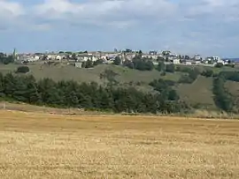 A general view of Châteauneuf-de-Randon | |
 Coat of arms | |
Location of Châteauneuf-de-Randon 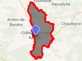
| |
 Châteauneuf-de-Randon  Châteauneuf-de-Randon | |
| Coordinates: 44°38′29″N 3°40′34″E | |
| Country | France |
| Region | Occitanie |
| Department | Lozère |
| Arrondissement | Mende |
| Canton | Grandrieu |
| Government | |
| • Mayor (2020–2026) | Bruno Durand[1] |
| Area 1 | 24.49 km2 (9.46 sq mi) |
| Population (2017-01-01)[2] | 550 |
| • Density | 22/km2 (58/sq mi) |
| Time zone | UTC+01:00 (CET) |
| • Summer (DST) | UTC+02:00 (CEST) |
| INSEE/Postal code | 48043 /48170 |
| Elevation | 1,116–1,339 m (3,661–4,393 ft) (avg. 1,286 m or 4,219 ft) |
| 1 French Land Register data, which excludes lakes, ponds, glaciers > 1 km2 (0.386 sq mi or 247 acres) and river estuaries. | |
History
The battle of Châteauneuf-de-Randon was fought in 1380 between the English and the French. In 1380 the fortress of Châteauneuf-de-Randon was besieged by the French, under the command of Bertrand du Guesclin, and the fortress was defended by an English garrison under De Ros. The town surrendered on the 4th of July. The siege, however, was fatal to the French commander.
Geography
The Chapeauroux forms part of the commune's western border, flows eastward through the middle of the commune, then forms part of its eastern border.
See also
References
- "Répertoire national des élus: les maires". data.gouv.fr, Plateforme ouverte des données publiques françaises (in French). 2 December 2020. Retrieved 7 December 2020.
- "Populations légales 2017". INSEE. Retrieved 6 January 2020.
External links
| Wikimedia Commons has media related to Châteauneuf-de-Randon. |
| Authority control |
|
|---|
This article is issued from Wikipedia. The text is licensed under Creative Commons - Attribution - Sharealike. Additional terms may apply for the media files.