Auroux
Auroux is a commune in the Lozère department in southern France.
Auroux | |
|---|---|
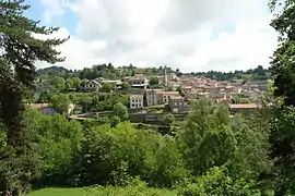 A general view of Auroux | |
 Coat of arms | |
Location of Auroux 
| |
 Auroux  Auroux | |
| Coordinates: 44°45′13″N 3°43′41″E | |
| Country | France |
| Region | Occitanie |
| Department | Lozère |
| Arrondissement | Mende |
| Canton | Langogne |
| Intercommunality | CC Haut Allier |
| Government | |
| • Mayor (2014-2020) | Anthony Martin |
| Area 1 | 35.09 km2 (13.55 sq mi) |
| Population (2017-01-01)[1] | 385 |
| • Density | 11/km2 (28/sq mi) |
| Time zone | UTC+01:00 (CET) |
| • Summer (DST) | UTC+02:00 (CEST) |
| INSEE/Postal code | 48010 /48600 |
| Elevation | 909–1,271 m (2,982–4,170 ft) (avg. 950 m or 3,120 ft) |
| 1 French Land Register data, which excludes lakes, ponds, glaciers > 1 km2 (0.386 sq mi or 247 acres) and river estuaries. | |
Geography
The Chapeauroux forms part of the commune's southern border, flows north through the middle of the commune, then forms part of its northern border.
Population
| Year | Pop. | ±% |
|---|---|---|
| 1793 | 1,048 | — |
| 1800 | 1,059 | +1.0% |
| 1806 | 1,118 | +5.6% |
| 1821 | 1,151 | +3.0% |
| 1831 | 1,092 | −5.1% |
| 1836 | 1,211 | +10.9% |
| 1841 | 1,242 | +2.6% |
| 1846 | 1,179 | −5.1% |
| 1851 | 1,266 | +7.4% |
| 1856 | 1,306 | +3.2% |
| 1861 | 1,222 | −6.4% |
| 1866 | 1,255 | +2.7% |
| 1872 | 1,266 | +0.9% |
| 1876 | 1,316 | +3.9% |
| 1881 | 1,264 | −4.0% |
| 1886 | 1,275 | +0.9% |
| 1891 | 1,325 | +3.9% |
| 1896 | 1,339 | +1.1% |
| 1901 | 1,309 | −2.2% |
| 1906 | 1,342 | +2.5% |
| 1911 | 1,285 | −4.2% |
| 1921 | 1,155 | −10.1% |
| 1926 | 1,025 | −11.3% |
| 1931 | 973 | −5.1% |
| 1936 | 965 | −0.8% |
| 1946 | 867 | −10.2% |
| 1954 | 685 | −21.0% |
| 1962 | 654 | −4.5% |
| 1968 | 561 | −14.2% |
| 1975 | 504 | −10.2% |
| 1982 | 438 | −13.1% |
| 1990 | 395 | −9.8% |
| 1999 | 380 | −3.8% |
| 2006 | 436 | +14.7% |
| 2009 | 428 | −1.8% |
| 2015 | 395 | −7.7% |
See also
References
- "Populations légales 2017". INSEE. Retrieved 6 January 2020.
External links
| Wikimedia Commons has media related to Auroux. |
- Official website (French)
| Authority control |
|---|
This article is issued from Wikipedia. The text is licensed under Creative Commons - Attribution - Sharealike. Additional terms may apply for the media files.