Chatham Parish, New Brunswick
Chatham is a civil parish in Northumberland County, New Brunswick, Canada.[2]
Chatham | |
|---|---|
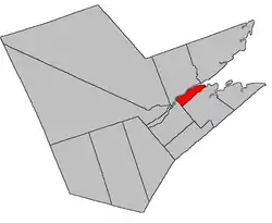 Location within Northumberland County, New Brunswick | |
| Coordinates: 47.045°N 65.37°W | |
| Country | |
| Province | |
| County | Northumberland |
| Erected | 1814 |
| Area | |
| • Land | 22.70 km2 (8.76 sq mi) |
| Population (2016)[1] | |
| • Total | 511 |
| • Density | 22.5/km2 (58/sq mi) |
| • Change 2011-2016 | |
| • Dwellings | 262 |
| Time zone | UTC-4 (AST) |
| • Summer (DST) | UTC-3 (ADT) |
For governance purposes it is divided between the city of Miramichi[3] and the local service district of the parish of Chatham,[4] both of which are members of the Greater Miramichi Regional Service Commission (GMRSC).[5]
Origin of name
The parish may have been named in honour of the Earl of Chatham, a title held at the time by General John Pitt, or for his father, former British Prime Minister Pitt the Elder.[6] The former seems more likely as six of the parishes erected simultaneously in Northumberland County in 1814[7] were named for prominent British military figures.
History
Chatham was erected in 1814 from Newcastle Parish.[7]
Delineation
Chatham Parish is defined in the Territorial Division Act[2] as being bounded:
- North by the main Miramichi River; southwest by Nelson [Parish], and south by Napan River, from its mouth to the northwest angle of lot number thirty-two (Henry Coil); thence south sixty-eight degrees west to Nelson Parish, including Middle Island.
Communities
- Lower Napan
- Middle Island
- Savoy Beach
- Snyders Beach
- Taintville
- Upper Napan
Demographics
Population
|
LanguageMother tongue (2016)[1]
|
See also
References
- "Census Profile, 2016 Census Chatham, Parish [Census subdivision], New Brunswick". Statistics Canada. Retrieved September 26, 2019.
- "Chapter T-3 Territorial Division Act". Government of New Brunswick. Retrieved 13 November 2020.
- "New Brunswick Regulation 85-6 under the Municipalities Act (O.C. 85-45)". Government of New Brunswick. Retrieved 19 July 2020.
- "New Brunswick Regulation 84-168 under the Municipalities Act (O.C. 84-582)". Government of New Brunswick. Retrieved 19 July 2020.
- "Communities in each of the 12 Regional Service Commissions (RSC) / Les communautés dans chacune des 12 Commissions de services régionaux (CSR)" (PDF), Government of New Brunswick, July 2017, retrieved 2 February 2021
- Ganong, William F. (1896). A Monograph of the Place-Nomenclature of the Province of New Brunswick. Royal Society of Canada. p. 226.
- "54 Geo. III c. 17 An Act in further addition to an Act, intituled 'An Act for the better ascertaining and confirming the boundaries of the several Counties, within this Province, and for subdividing them into Towns or Parishes.'". Acts of the General Assembly of His Majesty's Province of New-Brunswick; Passed in the Year 1814. Saint John, New Brunswick: Government of New Brunswick. 1814. pp. 16–18.
- Statistics Canada: 1996, 2001, 2006 census
- 2006 Statistics Canada Community Profile: Chatham Parish, New Brunswick
- 2011 Statistics Canada Census Profile: Chatham Parish, New Brunswick
Places adjacent to Chatham Parish, New Brunswick | ||||||||||
|---|---|---|---|---|---|---|---|---|---|---|
| ||||||||||
| Subdivisions | |
|---|---|
| Cities | |
| Counties | |
| |