Cheviot, New Zealand
Cheviot (/ˈtʃɪviət/) is a town in the Hurunui District of north Canterbury, on the east coast of the South Island of New Zealand. It is located on State Highway 1, approximately 112 kilometres (70 mi) north of Christchurch and 68 kilometres (42 mi) south of Kaikōura.
Cheviot | |
|---|---|
Town | |
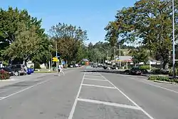 Hall St (State Highway 1), the main street of Cheviot | |
 Cheviot | |
| Coordinates: 42°48′46″S 173°16′26″E | |
| Country | New Zealand |
| Region | Canterbury |
| Territorial authority | Hurunui District |
| Elevation | 60 m (200 ft) |
| Population (2018) | |
| • Total | 372 |
| Time zone | UTC+12 (New Zealand Standard Time) |
| • Summer (DST) | UTC+13 (New Zealand Daylight Time) |
| Postcode | 7310 |
| Area code(s) | 03 |
| Local iwi | Ngāi Tahu |
| Website | http://www.cheviotnz.com/ |
History and naming
The government under Minister of Lands John McKenzie bought the Cheviot Hills estate from the descendants of William Robinson.[1][2] The Cheviot Hills estate was broken into 54 farms and a township, which was originally called Mackenzie.[3] This name was "in widespread use for a decade or two" but gradually fell into disuse. The post office was always known as Cheviot and by at least 1913 the township too was generally known as Cheviot.[4] Cheviot Hills estate had been named by its original lease holder, John Scott Taverhill, after his home country, the Cheviot Hills straddling the Anglo-Scottish border.[5]
Demographics
The Cheviot settlement had a usual resident population of 372 at the 2018 New Zealand census, an increase of 3 people (0.8%) since the 2013 census, and a decrease of 18 people (-4.6%) since the 2006 census. There were 186 males and 189 females, giving a sex ratio of 0.98 males per female. Of the total population, 60 people (16.1%) were aged up to 15 years, 42 (11.3%) were 15 to 29, 141 (37.9%) were 30 to 64, and 129 (34.7%) were 65 or older.[6]
Ethnicities were 87.9% European/Pākehā, 21.8% Māori, 4.0% Pacific peoples, and 1.6% Asian (totals add to more than 100% since people could identify with multiple ethnicities).[6]
| Cheviot population by year | |||
|---|---|---|---|
| Census | Pop. | Ref | |
| 1901 | 216 | [7] | |
| ... | ... | ||
| 2001 | 393 | ||
| 2006 | 390 | [8] | |
| 2013 | 369 | [9] | |
| 2018 | 372 | ||
The region
Cheviot is a service town for highway traffic and for a pastoral farming district that is currently predominant in sheep farming. Based in the township are a volunteer fire and ambulance services and one full-time police officer. Surrounding settlements include:
Domett
Originally a railway town, Domett is now only populated by farms and a petrol station. Next to the Old Main Road/Hurunui Mouth Road junction is the old Domett Railway Station, relocated and refurbished as a cafe. Domett Service Station provides after-hours sale of fuel (with surcharge): most service stations in the area close around 6pm.
Spotswood
Spotswood has an old hall that is still used regularly, and mainly consists of farms around Waiau East Road.
Parnassus
Parnassus has a higher population than the other settlements, although the local Parnassus School was closed in 2008.[10] The famous Waiau River road/rail bridge was here, before being abandoned and replaced with a new road bridge. Prior to the opening of the old bridge in the 1930s a ferry across the river carried goods north and south. The Waiau River ends not far away; however, access to the river mouth must be made over farm property with the owners' permission. On the State Highway north of Parnassus is Leader Road which leads to the townships of Waiau, Rotherham, Culverden and Hanmer Springs.
Gore Bay
Gore Bay is a surfing beach with summer beach houses and 14 permanent residents. There are two local camping grounds, each with beach access and business. It is a popular New Year's Eve venue.
Of note is Cathedral Gully, a spectacular weathered clay canyon.
Port Robinson
Once a prospering port, Port Robinson is now an abandoned wreck. The old wharf may still be seen, but it is in a dangerous state of disrepair.
Stonyhurst Station
Stonyhurst is a farming station in the Blythe Valley, southwest of Cheviot.
It was founded in 1851 by Frederick Weld and Charles Clifford. He had gained his impression when walking from Lyttelton to Flaxbourne, in Marlborough. Clifford landed sheep on the beach just south of the Blythe River which was later be going to be known as Stonyhurst Station, named after Stonyhurst College in England where they were both educated.
The farm originally occupied nearly 30,000 hectares (74,000 acres), the whole of the Blythe Valley. About 12,000 hectares (30,000 acres) was sold in 1863, and a further 4,000 hectares (9,900 acres) a decade later. In about 1900, much of the rest of the land was subdivided. The current station is about one tenth of the original area.[11]
The area is described by the local authority as "a potentially significant natural area",[12] and the manager's cottage is a Category II protected building under the Historic Places Act.[13]
Education
Schooling in Cheviot commenced in 1894. The first school was the McKenzie School, where the A&P Showgrounds are today. The name changed to Cheviot School in 1931. From its inception, the school provided primary education up to Form Two. In 1937, it became the Cheviot District High School.[14]
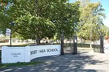
Cheviot Area School is a composite, co-educational school for Year 1 to 13 students. It also has a wider role providing continuing education, facilities and support for community groups.[14] The closest main contributing school, Parnassus, a year 1-6 school, closed in 2008.[15] It had a roll of 196 as of March 2020.[16]
Cheviot Area School competes in the Canterbury Area Schools Association Festival sporting competition with schools in Akaroa, Amuri, Hawarden, Oxford, and Rangiora. It also takes part in international exchanges with schools in Japan and Canada.[15]
The township has two preschools, Cheviot Learning Centre and The Tree Hut.
See also
References
- Brooking, Tom. "McKenzie, John 1839–1901". Dictionary of New Zealand Biography. Ministry for Culture and Heritage. Retrieved 9 April 2011.
- Gardner, William James. "Robinson, William - Biography". Dictionary of New Zealand Biography. Ministry for Culture and Heritage. Retrieved 29 September 2012.
- "Subdividing Cheviot Hills - roadside stories". Ministry for Culture and Heritage. 30 August 2012. Retrieved 29 September 2012.
- Wilson, John. "Cheviot Kingdom to County". Rangiora Printing Service, 1993, page 151. ISBN 0-473-10321-5. The difference in spelling between politician John McKenzie and the MacKenzie township is attributed to a mistake made by the then Commissioner of Crown Lands, Canterbury, John Marchant, on an early map.
- Reed, A. W. (2010). Peter Dowling (ed.). Place Names of New Zealand. Rosedale, North Shore: Raupo. p. 79. ISBN 9780143204107.
- "Age and sex by ethnic group (grouped total response), for census usually resident population counts, 2006, 2013, and 2018 Censuses (urban rural areas)". nzdotstat.stats.govt.nz. Retrieved 7 October 2020.
- Cyclopedia of New Zealand. "Cheviot and McKenzie". NZETC. Retrieved 2 November 2014.
- "QuickStats About Cheviot". 2006 Census. Statistics New Zealand. Retrieved 7 April 2010.
- "2013 Census QuickStats about a place: Cheviot". 2013 Census. Statistics New Zealand. Retrieved 1 November 2014.
- Silverstripe. "Parnassus Hall · Hurunui District Council". www.hurunui.govt.nz. Retrieved 31 March 2017.
- Crean, Mike (8 March 2008). "Where a station once grew". The Press. Archived from the original on 23 February 2013. Retrieved 25 June 2008.
- "Natural Environment" (PDF). District Plan. Hurunui District Council. p. 83. Retrieved 25 June 2008.
- "Heritage" (PDF). District Plan. Hurunui District Council. p. 95. Retrieved 25 June 2008.
- "Cheviot Area School Official School Website". cheviot.school.nz/.
- "Cheviot Area School Education Review Office Report". ero.govt.nz. Education Review Office.
- "Cheviot Area School Ministry of Education School Profile". educationcounts.govt.nz. Ministry of Education.
External links
![]() Media related to Cheviot, New Zealand at Wikimedia Commons
Media related to Cheviot, New Zealand at Wikimedia Commons
- Cheviot information at the Hurunui District Council
- Cheviot Promotions Group