Amberley, New Zealand
Amberley (Māori: Kōwai) is a town located in the Hurunui District in north Canterbury, on the east coast of the South Island of New Zealand. It is located on State Highway 1 approximately 50 km north of Christchurch. It is the seat of the Hurunui District Council. The nearest town to the north of Amberly via state highway one is Waipara (11km) and the nearest town to the south is Leithfield (5.7km).
Amberley
Kōwai (Māori) | |
|---|---|
| Country | New Zealand |
| Region | Canterbury |
| Territorial authority | Hurunui District |
| Area | |
| • Total | 2.95 km2 (1.14 sq mi) |
| Population (June 2020)[2] | |
| • Total | 2,270 |
| • Density | 770/km2 (2,000/sq mi) |
| Postcode | 7410 |
| Local iwi | Ngāi Tahu |
History
Amberley was established in 1864 by Mrs. Frederica Josephine Carter who owned freehold land north of the Kowai river. Mrs. Carter subdivided and sold her pastoral run for eight pounds per quarter acre. This price was very attractive as it made the land some of the cheapest in Canterbury. The town was named Amberley after Mrs. Carter's family farm in Oxfordshire, England. The earliest residents included a blacksmith, a wheelwright and a carpenter. A courthouse was established in 1870. The town developed slowly at first until the railway, built by Canterbury Provincial Railways, arrived in 1876. With the arrival of the railway, the town grew quickly and a town hall was completed in 1878 which could seat 400 people. The Anglican church was built in 1877 with room for 140 parishioners. It was destroyed by a "hurricane" in 1889 leaving only the tower standing. The church was then rebuilt at a cost of about £700. The Wesleyan church was built in 1882 with room for 120 parishioners.[3] A branch (a two-story building) of the Bank of New South Wales was established in Amberley in 1890. In 1908 a telephone exchange was opened in Amberley. By this time Amberley had 96 houses or other dwellings and was home to more than 800 people.[4]
Demographics
The Amberley urban area had a usual resident population of 2,067 at the 2018 New Zealand census, an increase of 486 people (30.7%) since the 2013 census, and an increase of 762 people (58.4%) since the 2006 census. There were 1,002 males and 1,065 females, giving a sex ratio of 0.94 males per female. Of the total population, 369 people (17.9%) were aged up to 15 years, 243 (11.8%) were 15 to 29, 777 (37.6%) were 30 to 64, and 675 (32.7%) were 65 or older.[5]
Ethnicities were 93.9% European/Pākehā, 7.4% Māori, 1.2% Pacific peoples, 2.8% Asian, and 2.2% other ethnicities (totals add to more than 100% since people could identify with multiple ethnicities).[5] The town has one of the lowest concentrations of non-European populations in New Zealand, with district council staff admitting the locals could identify all the Māori and Asians recorded.[6]
Economy
The economy in Amberley is in part based on providing services to the dairy farming, arable farming and sheep farming and grape growing industries in the wider district. Many people commute to jobs in Christchurch each day from Amberley.[7]
Climate
The warmest months of the year are January and February, with an average high temperature of 23°C. The coldest month of the year occurs in July, when the average high temperature is 11°C. Monthly rainfall ranges between an average of 48mm in January to 85mm in July. [8]
Local information
Amberley is the seat of the Hurunui District Council. Once a year, the local A&P (Agricultural and Pastoral) show is held, usually mid-Spring. The Amberley Swimming Pool is located at the Amberley Domain. It is a 25 yard, 5 lanes, solar heated, public swimming pool. There is also a playground, skate park, bowls club, tennis courts and multiple playing fields for rugby, soccer and cricket at the Amberley Domain.[9]
Notable buildings
The Church of the Holy Passion of our Lord
The Catholic Church of the Most Holy Passion was built in 1866 by Sir Frederick Weld. It was moved to its Amberley site on State Highway 1 in the mid-1950s.[10][11]
Holy Innocents Anglican Church
Located on Church Street.
Cob Cottage
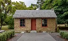
The Cob Cottage is located in Chamberlain Park. it suffered significant damage in 1975 because of gale force nor westerly winds. The damage was such that an upper floor had to be removed.[11] It is owned by the Amberley Historical Society and houses a collection of furnishings and clothing from the early settlers of the area.[12]
Amberley House
Amberley House was built between 1870 and 1876. In 1920 the property was converted into the Amberley House Girls’ Collegiate School. The house was extended by and converted into the school by building two stories to the original house. The school closed in 1942. [13] Previous owners built extensive stables to support a horse breeding business. There are extensive grounds and it operates part time as a wedding venue and offers garden tours.[14] [15]
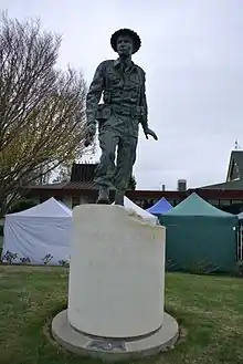
Charles Upham statue
There is a statue in memory of Charles Upham just outside the council building. Upham farmed in the Cheviot area. Nearby the statue sit three limestone carvings, labelled The Grandmothers, which celebrate the ancient Waitaha people. Carved by Sculptor Warren Thompson, the statues were unveiled in May 2003 by the Rt. Hon. Helen Clark, Prime Minister of New Zealand.
Education
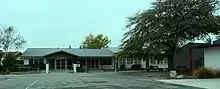
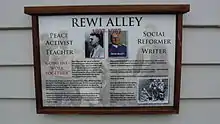
The Amberley school was established in 1872 with three classrooms. By 1902 it had 122 students.[16] Amberley School is a co-educational state primary school for Year 1 to 8 students,[17][18] with a roll of 224 as of March 2020.[19] Amberley Primary School's Rewi Alley Community Centre has a memorial to Rewi Alley who attended there.
Amberley Beach
Amberley itself sits inland on state highway one and the main train line running north from Christchurch to Picton. Amberley Beach is located 4.6km away from Amberley on Amberley Beach Road. A small number of houses, a camping ground and the Amberley Beach Reserve are located by the beach, Amberley Beach itself is a shingle rather than a sandy beach. It is popular for walking, swimming, surfing and fishing.[20] The Amberley beach walkway offers a 20 minute walk of native bush and water features. The Amberley Lions helped to build this walkway.[21]
Amberley Golf Course
Amberley has an 18 hole golf course that runs tournaments throughout the year. The Amberley Golf Club was founded in 1922. The golf course was originally a total of 9 holes based on sheep paddocks opposite Amberley House on state highway one. By 1940 the number of members increased to 63. Electricity was installed in the club-house. Due to World War 2, the club went into recess in 1942 and the course reverted to sheep paddocks. In 1954, a new course at Amberley Beach was proposed. With much voluntary effort a 13 holes course was formed and opened for play in 1955. Two further holes were added in 1957. The final three holes were completed in 1959. A new club-house was also built in 1959. In 1974, a pond was excavated near the seventeenth hole which provided irrigation for the course. Irrigating all the fairways continued to be a challenge and a new watering system was installed in 1992.[22]
References
- "2006 Census Meshblock Dataset". Archived from the original on 14 August 2008.
- "Population estimate tables - NZ.Stat". Statistics New Zealand. Retrieved 22 October 2020.
- "Amberley | NZETC". nzetc.victoria.ac.nz. Retrieved 27 November 2020.
- "History – Amberley.co.nz". Retrieved 27 November 2020.
- "Age and sex by ethnic group (grouped total response), for census usually resident population counts, 2006, 2013, and 2018 Censuses (urban rural areas)". nzdotstat.stats.govt.nz. Retrieved 7 October 2020.
- Michelle Coursey (5 August 2007). "Our whitest region". The New Zealand Herald. Retrieved 13 October 2015.
When the Census figures come out, and say there are a certain number of Maori or Asian people, people know who they are. ... because there are so few.
- "Amberley | Enterprise North Canterbury". www.northcanterbury.co.nz. Retrieved 27 November 2020.
- "Climate Amberley". meteoblue. Retrieved 11 October 2020.
- "Sports – Amberley.co.nz". Retrieved 27 November 2020.
- "Landmarks – Amberley.co.nz". Retrieved 27 November 2020.
- "Amberley's heritage highlights". Stuff. 9 April 2012. Retrieved 27 November 2020.
- "Landmarks – Amberley.co.nz". Retrieved 27 November 2020.
- "Landmarks – Amberley.co.nz". Retrieved 27 November 2020.
- "Scandal and horseplay features of Amberley House history". Stuff. 4 December 2018. Retrieved 27 November 2020.
- "History". Amberley House. Retrieved 27 November 2020.
- "Amberley | NZETC". nzetc.victoria.ac.nz. Retrieved 27 November 2020.
- "Amberley School Official School Website". amberley.school.nz.
- "Amberley School Ministry of Education School Profile". educationcounts.govt.nz. Ministry of Education.
- "Amberley School Education Review Office Report". ero.govt.nz. Education Review Office.
- "Activities – Amberley.co.nz". Retrieved 27 November 2020.
- "Activities – Amberley.co.nz". Retrieved 27 November 2020.
- "History | Amberley Golf Club | New Zealand". amberleygolfclub. Retrieved 27 November 2020.