Chipata District
Chipata District is a district of Zambia, located in Eastern Province. The capital lies at Chipata. As of the 2010 Zambian Census, the district had a population of 455,783 people.[1]
Chipata District | |
|---|---|
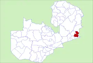 District location in Zambia | |
| Country | |
| Province | Eastern Province |
| Capital | Chipata |
| Population (2010) | |
| • Total | 455,783 |
| Time zone | UTC+2 (CAT) |

Chipata Town Centre is located about 600 km from Lusaka, the capital city of Zambia, while it is only 110 km from Lilongwe, the capital city of Malawi. Thus, Chipata accesses its imports mainly from Nacala and Dar es Salaam ports in Mozambique and Tanzania respectively, all routes passing through Malawi to Mwami Border. The District has a firm foundation of being a trade centre dating back to the colonial era of the current Zambia, when it was called Fort Jameson. This cornerstone has left the town as the hub of Eastern Province, by maintaining its position as a Provincial Headquarters.[2]
References
- "Districts of Zambia". Statoids. Retrieved February 12, 2010.
- "Times of Zambia". 2020-05-30.
| Central Province | |
|---|---|
| Copperbelt Province | |
| Eastern Province | |
| Luapula Province | |
| Lusaka Province | |
| Muchinga Province | |
| Northern Province | |
| North-Western Province | |
| Southern Province | |
| Western Province | |
