Mumbwa District
Mumbwa District is a district of Zambia, located in Central Province. The capital lies at Mumbwa. As of the 2010 Zambian Census, the district had a population of 218,328 people.[1]
Mumbwa District | |
|---|---|
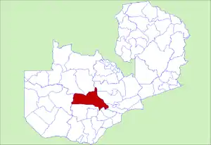 District location in Zambia | |
| Country | |
| Province | Central Province |
| Capital | Mumbwa |
| Area | |
| • Total | 21,103 km2 (8,148 sq mi) |
| Population (2015) | |
| • Total | 273,869 |
| • Density | 13/km2 (34/sq mi) |
| Time zone | UTC+2 (CAT) |
Towns
Mumbwa District's main population center is Mumbwa, which is close to another towns such as Kasip and Muembe. In the district's south are Banachewembwe and Namukumbo.
Bodies of Water
The Kafue River forms the district's boundary with Kasempa District before it bisects the district. On its banks is Game Scout Camp. The Chulwe fishing camp lies in Blue Lagoon National Park.[2]
Transportation
The roads that lie in the district are M9 (which merges with Moshi Road near Game Scout Camp and later reaches Lusaka), M20, D181, D183, and D769.
References
- "2010 CENSUS OF POPULATION AND HOUSING" (PDF). Republic of Zambia. Archived from the original (PDF) on July 7, 2012. Retrieved March 22, 2015.
- Samuel Mulenga Bwalya. "Critical Analysis of Community-Based Wildlife Resource Management in Southern Africa: Case Study from Zambia" (PDF). Department of Environmental and Natural Resource Economics of the University of Rhode Island. Archived from the original (PDF) on September 15, 2012. Retrieved December 30, 2013.
| Central Province | |
|---|---|
| Copperbelt Province | |
| Eastern Province | |
| Luapula Province | |
| Lusaka Province | |
| Muchinga Province | |
| Northern Province | |
| North-Western Province | |
| Southern Province | |
| Western Province | |
This article is issued from Wikipedia. The text is licensed under Creative Commons - Attribution - Sharealike. Additional terms may apply for the media files.