Katete District
Katete District with headquarters at Katete in Eastern Province, Zambia, includes woodland in the north sloping down into the Luangwa Valley, good farmland amid rocky hills in the centre, and deforested plateau exposed to soil erosion and degradation in the south along the border with Mozambique. As of the 2000 Zambian Census, the district had a population of 189,250 people.[1]
Katete District | |
|---|---|
.jpg.webp) Kazika village in Katete District | |
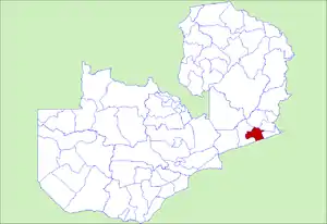 District location in Zambia | |
| Country | |
| Province | Eastern Province |
| Capital | Katete |
| Population (2000) | |
| • Total | 189,250 |
| Time zone | UTC+2 (CAT) |
References
- "Districts of Zambia". Statoids. Retrieved February 12, 2010.
| Central Province | |
|---|---|
| Copperbelt Province | |
| Eastern Province | |
| Luapula Province | |
| Lusaka Province | |
| Muchinga Province | |
| Northern Province | |
| North-Western Province | |
| Southern Province | |
| Western Province | |
This article is issued from Wikipedia. The text is licensed under Creative Commons - Attribution - Sharealike. Additional terms may apply for the media files.