Chirala
Chirala (![]() pronunciation ), is a city in Prakasam district of the Indian state of Andhra Pradesh. It is a municipality and the headquarters of Chirala mandal in Ongole revenue division.[5][6] As of 2011, it had a population of above 250,000.[3]
pronunciation ), is a city in Prakasam district of the Indian state of Andhra Pradesh. It is a municipality and the headquarters of Chirala mandal in Ongole revenue division.[5][6] As of 2011, it had a population of above 250,000.[3]
Chirala
Kshirapuri | |
|---|---|
[Town] | |
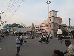 Clock Tower Centre in Chirala | |
| Nickname(s): Chirala;Kshirapuri;Chinna Bombay or Small Mumbai | |
.svg.png.webp) Chirala Location in Andhra Pradesh, India | |
| Coordinates: 15.8246°N 80.3521°E | |
| Country | India |
| State | Andhra Pradesh |
| District | Prakasam |
| Government | |
| • Type | Municipal council |
| • Body | Chirala Municipality |
| Area | |
| • Total | 23.30 km2 (9.00 sq mi) |
| Elevation | 3 m (10 ft) |
| Population | |
| • Total | 172,826 |
| • Density | 7,400/km2 (19,000/sq mi) |
| Languages | |
| • Official | Telugu,Urdu |
| Time zone | UTC+5:30 (IST) |
| PIN | 523 155 |
| Telephone code | +91–8594 |
| Vehicle registration | AP-27 |
| Website | Chirala Municipality |
Chirala is the most populated town in Bapatla Lok Shaba Parliamentary Constituency.
Etymology
The city was also known as Kshirapuri, which translates as the town of milk. The name got transformed to Chirala, where Chira means Saree.[7] The town and the surroundings were known of high-quality hand-loom industry.
Geography
The coordinates of the City are 15.8246°N 80.3521°E and is located at an altitude of 3 m (9.8 ft) from the coast of Bay of Bengal.[2]
Climate
The City experiences tropical climate with the average annual temperature records at 28.5 °C (83.3 °F). Hot summers and cool winters are observed due to its proximity to the coast of Bay of Bengal. It receives both South west monsoon and North-east monsoon as well. The precipitation is very high with an annual rainfall of about 200 millimetres (8 in) and the month of October receives a maximum rainfall of 197 millimetres (8 in).[8]
Governance
Chirala Municipality is the civic governing body of the city. It is a first grade municipality, constituted on 1 April 1948 and has a jurisdictional area of 13.57 km2 (5.24 sq mi) with 33 election wards.[1][9] The present Municipal Commissioner of the City is P.Sreenivasa Rao.[10] The constituents of Chirala urban agglomeration include, Chirala Municipality, census City of Chirala, Vetapalem; out growths of Ipurupalem and Kothapeta.[11]
Economy
Handloom weaving industry is one of the main occupation the city.[12] Several Cloth Market Complexes are situated in Chirala. Textile factories from Surat, Bombay, Gwalior supplying the goods directly to these markets. Clothes are cheap in Chirala Textile shops. Chirala is known as Small Bombay.
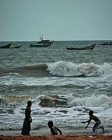
Chirala is famous tourist place for several beaches are at its coastal sea shores like Vadarevu Beach and Ramapuram Beach are famous here. Every weekend tourists are coming here from Hyderabad because Vadarevu Beach is nearest beach to Hyderabad and Telangana via Macherla and Nagarjuna Sagar Route than to Surya Lanka Beach.
Chirala has ITC Factory where Cigeragte raw materials processed and Cigerates are manufactured
Demographics
As of 2011 census of India, the city had a population of 172,826[13] with 23,070 households. It shows 2.04% growth in population, compared to 2001 Census of India which was recorded as 100,455.[14] The total population constitute, 52,927 males and 47,528 females —a sex ratio of 1031 females per 1000 males, higher than the national average of 940 per 1000.[15] 8,389 children are in the age group of 0–6 years, of which 4,253 are boys and 4,136 are girls —a ratio of 973 girls per 1000 boys. The average literacy rate stands at 78.80% with 62,099 literates, higher than the national average of 73.00%.[5][16]
The urban agglomeration population of the city is 162,471.[7][17]
Transport
The city is also well connected with National and State highways. The National Highway 216 passes through the town, which connects Ongole with Kattipudi . State Highway 48, also referred as Guntur-Bapatla-Chirala Road, connects the city with Guntur.[18] National Highway 167A connects it with Piduguralla, which passes through Narasaraopet and Chilakaluripet.[19]
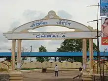
Public transport includes, the buses operated by state run APSRTC services. Chirala railway station is an A–Category station in Vijayawada railway division of South Central Railway zone. It is located on the Howrah-Chennai main line of Indian Railways.[20]
Education
The primary and secondary school education is imparted by government, aided and private schools, under the School Education Department of the state.[21][22] The medium of instruction followed by different schools are English and Telugu. VRS & YRN College is a famous college in Chirala. It has provided education requirements for decades now.
Chirala is an educational hub in Prakasam District, its Engineering colleges include St. Ann's College of Engineering and Technology, Chirala Engineering College and VRS & YRN College of Engineering. St Ann's Pharmacy College and Polytechnic College.
See also
- List of municipalities in Andhra Pradesh
References
- "Municipalities, Municipal Corporations & UDAs" (PDF). Directorate of CIty and Country Planning. Government of Andhra Pradesh. Archived from the original (PDF) on 28 January 2016. Retrieved 29 January 2016.
- "Maps, Weather, and Airports for Chirala, India". fallingrain.com.
- "Census 2011". The Registrar General & Census Commissioner, India. Retrieved 25 July 2014.
- "Statistical Abstract of Andhra Pradesh, 2015" (PDF). Directorate of Economics & Statistics. Government of Andhra Pradesh. p. 44. Archived from the original (PDF) on 14 July 2019. Retrieved 27 April 2019.
- "District Census Handbook – Prakasam" (PDF). Census of India. pp. 16–17, 44. Retrieved 18 January 2015.
- "Guntur District Mandals" (PDF). Census of India. pp. 141, 175. Retrieved 19 January 2015.
- "About Chirala Municipality". chirala.cdma.ap.gov.in. Retrieved 1 July 2017.
- "CLIMATE: CHIRALA". Retrieved 28 February 2016.
- "Municipality Profile". Commissioner & Director of Municipal Administration. Commissioner and Directorate of Municipal Administration, Andhra Pradesh. Retrieved 6 August 2014.
- "Key Contacts". chirala.cdma.ap.gov.in. Retrieved 9 July 2017.
- "Name of Urban Agglomeration and its State constituent Units-2011" (PDF). Census of India. p. 23. Retrieved 9 July 2017.
- Murali, S (14 October 2015). "Chirala weavers upbeat over heavy procurement orders". The Hindu. Chirala. Retrieved 2 March 2016.
- http://www.censusindia.gov.in/pca/Searchdata.aspx
- "Census of India 2001: Data from the 2001 Census, including cities, villages and towns (Provisional)". Census Commission of India. Archived from the original on 16 June 2004. Retrieved 1 November 2008.
- "Sex Ratio". The Registrar General & Census Commissioner, India. Retrieved 29 August 2014.
- "Chapter–3 (Literates and Literacy rate)" (PDF). Registrar General and Census Commissioner of India. Retrieved 29 August 2014.
- "Chirala Metropolitan Urban Region Population 2011 Census". census2011.co.in. Retrieved 1 July 2017.
- Samuel Jonathan, P (8 October 2015). "Nizampatnam backwaters beckon adventure geeks". The Hindu. Guntur. Retrieved 29 February 2016.
- "Road Maps". Roads and Buildings Department. Government of Andhra Pradesh. Archived from the original on 23 February 2016. Retrieved 28 February 2019.
- "Vijayawada division – A Profile" (PDF). South Central Railway. Archived from the original (PDF) on 28 January 2016. Retrieved 29 February 2016.
- "School Education Department" (PDF). School Education Department, Government of Andhra Pradesh. Archived from the original (PDF) on 27 December 2015. Retrieved 7 November 2016.
- "The Department of School Education – Official AP State Government Portal | AP State Portal". www.ap.gov.in. Archived from the original on 7 November 2016. Retrieved 7 November 2016.
| Wikimedia Commons has media related to Chirala. |