Chiswick Eyot
Chiswick Eyot /ˈtʃɪzɪk ˈeɪt/ is a 3.266-acre (1.3 ha) narrow, uninhabited ait (river island) in the River Thames. It is a tree- and reed-covered rise on the Tideway by Chiswick, in the Borough of Hounslow, London, England and is overlooked by St Nicholas Church, Chiswick, the Mall (promenade street) of Hammersmith and by some of the Barnes riverside on the far bank. Excluding tidal mudflats and sandbanks, it is the most downstream island purely on the Thames itself (as the Isle of Sheppey, Canvey Island and two nearby islets in the estuary are co-fed by creeks and in the case of Sheppey by complex mouths of the Medway).

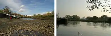
Position and race distance marker
It is beside The Championship Course and marks the approximate half-way point of The Boat Races (OUBC versus CUBC Men's and Women's first eights (1st 8+s) races) and the country's international Head of the River Race among others. A green pole stands on one end used for timings by rowers of that course, at the southwest, church end of the island.[1] Small craft can pass between it and (the)[n 1] Chiswick Mall[n 2] on the Middlesex (left, generally north) bank for about two hours at high tide, but the small channel is generally impassable otherwise — at low tide it is possible to walk to it as it is a tidal island.[2]
History

Chiswick Eyot is one of 43 unbridged tidal islands which can be walked to from the mainland of Great Britain.[3] The 3.266-acre (1.3 ha)[4] eyot was long-owned by the rectory of Chiswick and its natural successors the Ecclesiastical Commissioners until 1934 when ownership passed to the local council.[3] Little is known of its archaeology. St. Nicholas Church, Chiswick, whose tower was built in the 15th century, is 200m west of the island.[5] Thus an early medieval parish church is beside it as with Isleworth Ait, Eel Pie Island (Twickenham Ait) and others upstream.
The eyot was used during the industrial revolution mostly for the growing of grass and osiers (basket willows, used for basketry, furniture, cart-making, as well as cattle fodder). Its south-west end, opposite end and east has become indented. The island is submerged (excluding trees) at high tide.
Local nature reserve
The London Borough of Hounslow declared the island a local nature reserve of Greater London in 1993.[6][7]
See also
Notes and Citations
- Notes
- Use of "the" in "the Chiswick Mall" is becoming obsolete even among the most-settled upper middle class and British aristocracy in West London; c.f. The Kings Road (in general usage) and "The Victoria Embankment", as in Embankment Underground station invariably omitting one or two of these words that precede "Embankment"
- Mall in the meaning given in London refers to a scenic street; Chiswick, Upper and Lower Malls are three riverside roads lined with houses, pubs and a few river-related organisations.
- Citations
- Vesta Rowing Club — Veterans Head/ Pairs Head of the River Race
- Ordnance Survey map, courtesy of English Heritage Archived 24 April 2012 at the Wayback Machine
- "Kew to Wandsworth". Tideway. John Kennett. Archived from the original on 7 February 2007. Retrieved 5 January 2009.
- OS 25-inch map of 1910 Ordnance Survey Surrey II.10 revised 1910, published 1913.
- St Nicholas Church, Chiswick Grade II* listing Historic England. "Details from listed building database (1189405)". National Heritage List for England. Retrieved 21 November 2012.
- "Chiswick Eyot". Local Nature Reserves. Natural England. 1 March 2013. Retrieved 22 January 2014.
- "Map of Chiswick Eyot". Local Nature Reserves. Natural England. Retrieved 22 January 2014.
References
- Cornish, C. J. (1902). The naturalist on the Thames. London: Seeley. p. 68. OCLC 3251979. Archived from the original on 22 August 2007. Retrieved 18 March 2007.
External links
| Wikimedia Commons has media related to Chiswick Eyot. |
| Next island upstream | River Thames | Next island downstream |
| Oliver's Island | Chiswick Eyot | Lower Horse Island |