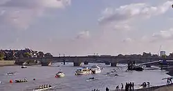
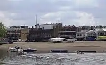
The Championship Course
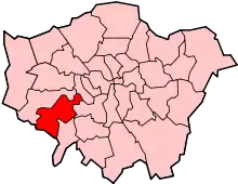
The stretch of the River Thames between Mortlake and Putney in London, England is a well-established course for rowing races, particularly the Oxford and Cambridge Boat Race. It is often referred to as The Championship Course. The course is on the tidal reaches of the river often referred to as the Tideway. Due to the iconic shape of the Championship Course, in orthopaedic surgery, an "S" shaped incision along the crease of the elbow is commonly referred to as "a boat-race incision resembling the River Thames from Putney to Mortlake."[1]
History
In 1845, it was agreed to stage the Boat Race (which had on five previous occasions been rowed from Westminster Bridge to Putney) on a course from 'Putney Bridge to Mortlake Church tower'.[2] The aim was to reduce the interference from heavy river traffic.
The following year, a race for the Professional World Sculling Championship moved to the course for the first time. The Wingfield Sculls followed in 1861.
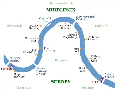
The course was later defined by two stones on the southern bank of the river, marked "U.B.R." for University Boat Race: one just downstream of Chiswick Bridge, close to The Ship public house, and the other just upstream of Putney Bridge. The course distance is 4 miles and 374 yards (6,779 m), as measured along the centre of the river's stream.
Races are always rowed in the same direction as the tide: from Mortlake to Putney on an ebb tide or from Putney to Mortlake on a flood tide.
Since the Boat Race moved to this course in 1845, it has always been raced on a flood tide from Putney to Mortlake except in 1846, 1856 and 1863. The Wingfield Sculls is also raced from Putney to Mortlake. Most other events race on an ebb tide from Mortlake to Putney.
In April 1869, the Harvard University Boat Club challenged the Oxford University Boat Club to an "International University Boat-Race" of coxed fours on the Boat Race course. The race took place on 27 August 1869 and was narrowly won by Oxford. The new Atlantic cable allowed daily reports to be received by all major newspapers across America within 23 minutes of the finish. U.S. public interest in the event was huge, with more publicity than any sporting event to date, and within two years of the event the "newly awakened interest in rowing at many of the most noted seats of learning" doubled the number of boat clubs in the US, and led to the formation of the Rowing Association of American Colleges.[3]
Landmarks
Principal landmarks, often used when racing, include (in order from Mortlake to Putney):
| Landmark | Bank | Coordinates | Comments |
|---|---|---|---|
| The University Stone | South | 51.472861°N 0.268151°W |   |
| Stag Brewery | South | 51.470474°N 0.266376°W | 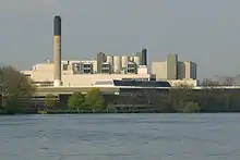 |
| Barnes Railway Bridge | n/a | 51.472736°N 0.253758°W | 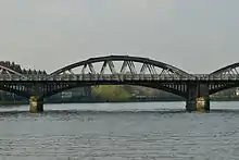 |
| The Bandstand | North | 51.476572°N 0.252149°W |  |
| The Crossing | n/a | 51.47879°N 0.250583°W | Marks the start of the long Surrey bend. |
| Chiswick Pier | North | 51.482452°N 0.250937°W |  |
| Chiswick Steps | South | 51.484581°N 0.247463°W | Steps for the ferry which used to run across to the slipway in front of St Nicholas' Church on the North side. |
| Chiswick Eyot | North | 51.487596°N 0.245814°W |  |
| Fuller's Brewery | North | 51.487182°N 0.250411°W |  |
| St Paul's School | South | 51.488983°N 0.235855°W |  |
| Hammersmith Bridge | n/a | 51.488129°N 0.230536°W | 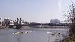 |
| Harrods Furniture Depository | South | 51.484633°N 0.227956°W |  |
| The Crabtree | North | 51.482041°N 0.223482°W |  |
| The Mile Post | South | 51.47852°N 0.226987°W |  |
| Fulham Football Club | North | 51.474895°N 0.221655°W | 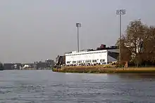 |
| The Black Buoy | South | 51.471211°N 0.221132°W |  |
| The Putney Stone | South | 51.467319°N 0.213756°W |  |
Events
- Boustead Cup (February/March)
- Women's Eights Head of the River Race (March)
- Schools' Head of the River Race (March)
- Head of the River Race (March/April)
- Veterans Head (March)
- The Boat Races – The Boat Race, Women's Boat Race and The Lightweight Boat Races [4] (March/April)
- Wingfield Sculls (October/November)
- Pairs Head of the River (rowed as far as Harrods) (October)
- Head of the River Fours (November)
- Veteran Fours Head of the River (November)
- Scullers Head (November/December)
Rowing clubs along the course
- Tideway Scullers School
- Thames Tradesmen's Rowing Club
- Emanuel School Boat Club
- Cygnet Rowing Club
- Barnes Bridge Ladies Rowing Club
- Sons of the Thames Rowing Club
- Latymer Upper School Boat Club
- Furnivall Sculling Club
- St Pauls School Boat Club
- Auriol Kensington Rowing Club
- Nautilus Rowing Club (British Rowing headquarters)
- Fulham Reach Rowing Club
- Barn Elms Rowing Club
- Parr’s Priory Rowing Club
- Imperial College Boat Club
- Thames Rowing Club
- Vesta Rowing Club
- Crabtree Boat Club
- King's College School Boat Club
- Dulwich College Boat Club
- Westminster School Boat Club
- HSBC Rowing Club
- London Rowing Club
- Putney High School Boat Club
- The London Oratory School Boat Club
References
- Wolfe, Scott (2017). Green's Operative Hand Surgery. Philadelphia, PA: Elsevier. p. 875. ISBN 9781455774272.
- Parishes: Putney, A History of the County of Surrey: Volume 4 (1912), pp. 78–83. Date accessed: 31 March 2010
- Miller, Bill (2006). "1869 – The Great International Boat Race". Friends of Rowing History. Retrieved 8 April 2008.
- https://www.lightweightboatraces.co.uk/
External links
- The Port of London Rowing Chart includes a map of the course showing detailed rules for rowers, the deep water channel, local rowing clubs and other landmarks.
The Boat Races | |||
|---|---|---|---|
 |  | ||
| |||
| |||