Royal Borough of Greenwich
The Royal Borough of Greenwich (/ˈɡrɛnɪtʃ/ (![]() listen), /ˈɡrɪnɪdʒ/, /ˈɡrɪnɪtʃ/ or /ˈɡrɛnɪdʒ/)[2][3] is a London borough in southeast Greater London. The London Borough of Greenwich was formed in 1965 by the London Government Act 1963. The new borough covered the former area of the Metropolitan Borough of Greenwich and part of the Metropolitan Borough of Woolwich to the east. The local council is Greenwich London Borough Council which meets in Woolwich Town Hall. The council's offices are also based in Woolwich, the main urban centre in the borough.
listen), /ˈɡrɪnɪdʒ/, /ˈɡrɪnɪtʃ/ or /ˈɡrɛnɪdʒ/)[2][3] is a London borough in southeast Greater London. The London Borough of Greenwich was formed in 1965 by the London Government Act 1963. The new borough covered the former area of the Metropolitan Borough of Greenwich and part of the Metropolitan Borough of Woolwich to the east. The local council is Greenwich London Borough Council which meets in Woolwich Town Hall. The council's offices are also based in Woolwich, the main urban centre in the borough.
Royal Borough of Greenwich | |
|---|---|
 Council logo | |
| Motto(s): We Govern by Serving | |
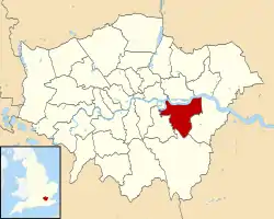
 Greenwich shown within Greater London | |
| Sovereign state | United Kingdom |
| Constituent country | England |
| Region | London |
| Ceremonial county | Greater London |
| Created | 1 April 1965 |
| Admin HQ | Woolwich |
| Government | |
| • Type | London borough council |
| • Body | Greenwich London Borough Council |
| • Leadership | Leader & Cabinet (Labour) |
| • Mayor | Councillor Mick Hayes |
| • London Assembly | Len Duvall (Labour) AM for Greenwich and Lewisham |
| • MPs | Abena Oppong-Asare (Labour) Clive Efford (Labour) Matthew Pennycook (Labour) |
| Area | |
| • Total | 18.28 sq mi (47.35 km2) |
| Area rank | 266th (of 317) |
| Population (mid-2019 est.) | |
| • Total | 287,942 |
| • Rank | 47th (of 317) |
| • Density | 16,000/sq mi (6,100/km2) |
| • Ethnicity[1] | 52.3% White British 1.7% White Irish 0.2% White Gypsy or Irish Traveller 8.3% Other White 1.6% White & Black Caribbean 1.1% White & Black African 0.9% White & Asian 1.3% Other Mixed 3.1% Indian 1% Pakistani 0.6% Bangladeshi 2% Chinese 5% Other Asian 13.8% Black African 3.2% Black Caribbean 2.1% Other Black 0.4% Arab 1.4% Other |
| Time zone | UTC (GMT) |
| • Summer (DST) | UTC+1 (BST) |
| Postcodes | |
| Area code(s) | 020 |
| ONS code | 00AL |
| GSS code | E09000011 |
| Police | Metropolitan Police |
| Website | http://www.royalgreenwich.gov.uk |
Greenwich is the location of the Greenwich prime meridian, on which all Coordinated Universal Time is based. The prime meridian running through Greenwich and the Greenwich Observatory is where the designation Greenwich Mean Time, or GMT began, and on which all world times are based. In 2012, Greenwich was listed as a top ten global destination by Frommer's – the only UK destination to be listed.
To mark the Diamond Jubilee of Elizabeth II, Greenwich became a Royal Borough on 3 February 2012, due in part to its historic links with the Royal Family, and to its UNESCO World Heritage Site status as home of the Prime Meridian.[4][5][6]
History
The London Borough of Greenwich was formed in 1965 by merging the former areas of the metropolitan boroughs of Greenwich and most of Woolwich (with the exception of North Woolwich, north of the river, which became part of the London Borough of Newham).
The name 'Charlton' was briefly considered for the borough.[7] Greenwich once applied for city status, but was turned down. If the application had been accepted the borough would have been known as the City of Greenwich, similarly to the City of Westminster.
To mark the Diamond Jubilee of Elizabeth II, on 3 February 2012 Greenwich became the fourth Royal Borough, an honour additional to its historic links with the Royal Family, and its status as home of the Prime Meridian and as a UNESCO World Heritage Site.
Geography
The borough lies along the south bank of the River Thames between Deptford and Thamesmead. It has an area of 5,044 hectares. Because of the bends of the river, its waterfront is as long as 8.5 miles. Travelling south away from the waterfront, the ground rises: Shooters Hill in the east and the high ground of Blackheath in the west bookend the borough, Eltham to the south of these hills falls away slightly.
Greenwich is bounded by the London Boroughs of Bexley to the east, Bromley to the south, Lewisham to the west and across the River Thames to the north lie Tower Hamlets, Newham and Barking and Dagenham.
Demographics
The borough's population in 2011 was 254,557.[8] 52.3% of the community defined themselves as White British. The largest minority groups represented were of Black and Asian heritage.
Approximately 44,500 international migrants arrived in the Royal Borough between the years 2001 and 2011.[9] Of these, 25% arrived from EU member states, 24.5% arrived from central and western Africa, and 18.9% arrived from southern Asia.[9] The most common country of birth in this period was Nigeria.[9]
The Royal Borough in 2015 had a general fertility rate of 72.7 live births per 1,000 aged 15–44, higher than the London average of 63.9 and the England average of 62.5.[9]
| Year | Pop. | ±% |
|---|---|---|
| 1801 | 16,866 | — |
| 1811 | 20,900 | +23.9% |
| 1821 | 25,208 | +20.6% |
| 1831 | 30,113 | +19.5% |
| 1841 | 38,284 | +27.1% |
| 1851 | 52,190 | +36.3% |
| 1861 | 74,801 | +43.3% |
| 1871 | 97,413 | +30.2% |
| 1881 | 120,024 | +23.2% |
| 1891 | 174,316 | +45.2% |
| 1901 | 185,062 | +6.2% |
| 1911 | 196,471 | +6.2% |
| 1921 | 213,562 | +8.7% |
| 1931 | 232,142 | +8.7% |
| 1941 | 227,864 | −1.8% |
| 1951 | 223,674 | −1.8% |
| 1961 | 220,305 | −1.5% |
| 1971 | 216,993 | −1.5% |
| 1981 | 209,868 | −3.3% |
| 1991 | 213,488 | +1.7% |
| 2001 | 214,540 | +0.5% |
| 2011 | 254,557 | +18.7% |
| Note:[10] | ||
Ethnicity
| Ethnic Group | 2001[11] | 2011[12] | ||
|---|---|---|---|---|
| Number | % | Number | % | |
| White: British | 151,291 | 70.6% | 133,130 | 52.3% |
| White: Irish | 4,871 | % | 4,291 | 1.7% |
| White: Gypsy or Irish Traveller | 430 | 0.2% | ||
| White: Other | 9,195 | % | 21,581 | 8.3% |
| White: Total | 165,357 | % | 159,002 | 62.5% |
| Asian or Asian British: Indian | 9,389 | % | 7,836 | 3.1% |
| Asian or Asian British: Pakistani | 1,909 | % | 2,594 | 1.0% |
| Asian or Asian British: Bangladeshi | 1,236 | % | 1,645 | 0.6% |
| Asian or Asian British: Chinese | 2,540 | % | 5,061 | 2.0% |
| Asian or Asian British: Other | 2,044 | % | 12,758 | 5.0% |
| Asian or Asian British: Total | 17,118 | % | 29,894 | 11.7% |
| Black or Black British: African | 15,312 | % | 35,164 | 13.8% |
| Black or Black British: Caribbean | 6,782 | % | 8,051 | 3.2% |
| Black or Black British: Other Black | 1,693 | % | 5,440 | 2.1% |
| Black or Black British: Total | 23,787 | % | 48,655 | 19.1% |
| Mixed: White and Black Caribbean | 2,175 | % | 4,011 | 1.6% |
| Mixed: White and Black African | 933 | % | 2,699 | 1.1% |
| Mixed: White and Asian | 1,353 | % | 2,361 | 0.9% |
| Mixed: Other Mixed | 1,389 | % | 3,203 | 1.3% |
| Mixed: Total | 5,850 | % | 12,274 | 4.8% |
| Other: Arab | 1,069 | 0.4% | ||
| Other: Any other ethnic group | 2,378 | % | 3,663 | 1.4% |
| Other: Total | 2,378 | % | 4,732 | 1.9% |
| Black, Asian, and minority ethnic: Total | 49,133 | % | 95,555 | 37.5% |
| Total | 214,490 | 100.00% | 254,557 | 100.00% |
Landmarks

Central Greenwich Town contains a UNESCO World Heritage Site centred on Christopher Wren's Royal Naval College and the Old Royal Observatory.
Civic affairs
Mayor
The 2013/14 Mayor was Cllr Angela Cornforth. The 2014/15 Mayor was Cllr M Hayes. The 2015/16 Mayor was Cllr Norman Adams.[13] The 2016/17 Mayor is Cllr Olu Babatola, the first African born individual to be elected to the office.[14]
Shaped like an astrolabe, the 18-carat gold badge on the Mayor's chain embodies the time-ball on the principal building of the old Greenwich Royal Observatory, the meridian line, and lines of latitude and longitude. The ‘time-ball’ is set with small rubies.
Executive
The Executive is composed of ten Labour members, led by Cllr Danny Thorpe(Shooters Hill ward) who has been Leader of the Council since 2018.
Coat of arms
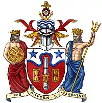
Arms were originally granted to the London Borough by letters patent dated 1 October 1965.[15] Although much of the 1965 design has been retained, the arms have been altered in 2012 by the addition of a representation of the Thames. In addition a crest and supporters were added to the arms.[16]

Twinning
The Royal Borough of Greenwich is twinned with:
 – Reinickendorf, Berlin, Germany (since 1965). The initiative of the twinning with this Berlin borough dates from the times of the Metropolitan Borough of Woolwich. A London telephone box and a red pillar box beside Lake Tegel were gifted by Greenwich borough. A Berlin Buddy Bear in General Gordon Square (Woolwich) commemorates the 50th anniversary of the twinning.[17]
 – Maribor, Slovenia (since 1966).[17] The 50th anniversary of the town twinning with Slovenia's second largest city was celebrated with a ballet performance in Woolwich Town Hall and the revealing of a plaque in the renamed Maribor Park in the Royal Arsenal.[18]
 – Tema, Ghana (since 2000). The town twinning with Tema has led to the opening of Tema's first Information Technology Centre (by the Duke of Edinburgh in 2000), the gifting of a mobile ICT learning centre to Tema (2005), the shipping of a converted Greenwich council passenger services bus, packed with books for school libraries and second-hand computers, as well as regular youth exchanges between Greenwich and Tema.[17]
Politics
Greenwich London Borough Council

Greenwich London Borough Council comprises 51 councillors. The Labour Party currently has an overall majority on the council, holding 43 seats, with the Conservatives holding 8. Labour has had a majority on the council since 1971.
There are 17 wards in Greenwich:
- Abbey Wood
- Blackheath-Westcombe
- Charlton
- Coldharbour and New Eltham
- Eltham North
- Eltham South
- Eltham West
- Glyndon
- Greenwich West
- Peninsula
- Kidbrooke with Hornfair
- Middlepark and Sutcliffe
- Plumstead
- Shooters Hill
- Thamesmead Moorings
- Woolwich Common
- Woolwich Riverside
Westminster Parliament
The borough contains the constituencies of:
- Eltham
- Erith and Thamesmead (shared with the London Borough of Bexley)
- Greenwich and Woolwich
Since the 2010 General Election, all three are represented by Labour MPs.
Education
Schools
Further education
Greenwich Community College is the main publicly funded provider of further education in the borough, offering a range of academic and vocational courses and qualifications. Anglian College London is a private college offering further and higher education courses to students from around London and overseas. In September 2013, The Royal Borough of Greenwich Equestrian Centre – a partnership between Hadlow College and the Royal Borough of Greenwich – opened. At present it offers Level 1 and Level 2 qualifications in horse care, as well as a range of part-time qualifications and a BSc (Hons) degree in Equine Sports Therapy and Rehabilitation. In September 2010 Ravensbourne opened its new campus at Greenwich Peninsula.[19]
Universities
The University of Greenwich main campus is located in the distinctive buildings of the former Royal Naval College. There is a further campus of the university at Avery Hill in Eltham, and also, outside the borough, in Medway. The Faculty of Music of Trinity Laban Conservatoire of Music and Dance, (formerly known as Trinity College of Music) is also housed in the buildings of the former Greenwich Hospital.
Sport within the borough
Greenwich Council owns many sports centres and these are operated by Greenwich Leisure Limited (GLL). They also run an outdoor swimming pool, the Charlton Lido.
The largest football club in the borough is Charlton Athletic F.C., a professional club playing in the EFL League One, There are two non-League football clubs, Bridon Ropes F.C. and Meridian F.C., who both play in Woolwich at Meridian Sports & Social Club. There are several Rugby clubs, most notably Blackheath F.C., who played at Rectory Field for 158 years, moving to Eltham in 2016. Blackheath Cricket Club still plays at Rectory Field.
Greenwich was one of the five host boroughs for the 2012 Summer Olympics and hosted 34 events in nine sports at three venues across the borough.[20] Greenwich Park hosted equestrian events and modern pentathlon; the Royal Artillery Barracks in Woolwich hosted shooting events; and The O2 arena hosted gymnastics and basketball finals.
Transport
River crossings
There are foot tunnels under the River Thames between Greenwich and Island Gardens in the London Borough of Tower Hamlets and between Woolwich and North Woolwich in the London Borough of Newham. The Woolwich Ferry takes vehicle traffic and links the North Circular Road to the South Circular Road which runs through the borough. A cable car crossing linking Greenwich Peninsula to the Royal Docks opened on 28 June 2012.[21]
River transport
The Thames Clippers commuter ferry service runs from Woolwich to Canary Wharf and the City.
Railway stations
- Abbey Wood
- Blackheath
- Charlton
- Eltham
- Greenwich
- Kidbrooke
- Maze Hill
- Mottingham
- New Eltham
- Plumstead
- Westcombe Park
- Woolwich Arsenal
- Woolwich Dockyard
All stations are served by Southeastern.
Crossrail stations are currently under construction at Woolwich and Abbey Wood.
Tube/DLR stations
North Greenwich on the Jubilee line is the only London Underground station in the borough and was opened recently in 1999. The DLR serves Greenwich more extensively and a list of the stations is below:
Travel to work
In March 2011, the main forms of transport that residents used to travel to work were driving a car or van, 17.5% of all residents aged 16–74; train, 10.2%; bus, minibus or coach, 10.2%; underground, metro, light rail, tram, 9.7%; on foot, 4.1%; work mainly at or from home, 2.5%; and bicycle, 1.5%.[22]
Economy
Tourism
Tourism is becoming an increasingly important factor in Greenwich's economy. In 2015, 18.5 million people are expected to visit the borough for a day or more, generating over £1.2 billion; this figure is expected to increase by more than 25% by 2018. Evidence of the tourism boom includes the construction of a 452-room InterContinental Hotel near the O2 Arena (opening in 2015) and London's first cruise ship terminal, at Enderby Wharf (opening 2017). Apart from the many museums and historic buildings in Greenwich town and Greenwich Park, the main tourist attractions are the Cutty Sark, The O2 Arena, Emirates Air Line (cable car), Eltham Palace (which expected over 100,000 visitors in 2015), Charlton House and the Thames Barrier. In addition, the Royal Arsenal in Woolwich is starting to promote itself as a tourist attraction.[23]
Places
Parks and open spaces
The borough contains the Greenwich Royal Park. A small part of the Metropolitan Green Belt is within the borough.
Entertainment district
The O2 (formerly the Millennium Dome) is located on the Greenwich Peninsula. It includes an indoor arena, a music club, a Cineworld cinema, an exhibition space, piazzas, bars, and restaurants.
Religion
The Greenwich borough is predominantly Christian (2001 Census). The Christian Church is represented by various denominations, among which are Church of England, Roman Catholic, Methodist, Baptist, Evangelical, Brethren, Pentecostal, Quakers, etc. Non-Trinitarian groups also exist. Besides these there are various other religious minorities including Sikhs, Muslims, Hindus and Jews.
In the 2001 Census, 29% of Greenwich described themselves as non-religious, or did not state their faith.[24]
See also
References
- 2011 Census: Ethnic group, local authorities in England and Wales, Office for National Statistics (2012). See Classification of ethnicity in the United Kingdom for the full descriptions used in the 2011 Census.
- "Greenwich". Oxford English Dictionary (Online ed.). Oxford University Press. (Subscription or participating institution membership required.)
- Roach, Peter; Setter, Jane; Esling, John, eds. (2011). Cambridge English Pronouncing Dictionary (David Jones) (18th ed.). Cambridge: Cambridge University Press.
- "Greenwich to become Royal Borough". Greenwich London Borough Council. 5 January 2010. Archived from the original on 8 January 2010. Retrieved 5 January 2010.
- "Greenwich to become Royal Borough on 3 February". Greenwich Council. 9 January 2012. Archived from the original on 1 August 2012. Retrieved 14 January 2012.
- Letters Patent dated 3 February 2012 "No. 60205". The London Gazette. 11 July 2012. p. 13300.
- "Names for Nine New Boroughs of London" The Times, 14 September 1963
- http://www.ons.gov.uk/ons/rel/census/2011-census/key-statistics-and-quick-statistics-for-wards-and-output-areas-in-england-and-wales/rft---qs211ew-wm.xls
- http://www.greenwichjsna.org/app/uploads/2015/08/Demography_JSNA-1.pdf
- "Greenwich: Total Population". A Vision of Britain Through Time. Great Britain Historical GIS Project. Retrieved 6 September 2011.
- "KS006 - Ethnic group". NOMIS. Retrieved 30 January 2016.
- "Ethnic Group by measures". NOMIS. Retrieved 8 January 2016.
- Royal Borough of Greenwich (6 October 2011). "About our current Mayor | The Mayor of the Royal Borough of Greenwich". Royalgreenwich.gov.uk. Retrieved 22 August 2018.
- "About our current Mayor | The Mayor of the Royal Borough of Greenwich". Royalgreenwich.gov.uk. 6 October 2011. Retrieved 22 August 2018.
- Briggs, Geoffrey (1971). Civic and Corporate Heraldry: A Dictionary of Impersonal Arms of England, Wales and Northern Ireland. London: Heraldry Today. pp. 184–185. ISBN 0-900455-21-7.
- "The borough's coat of arms and crest". Greenwich Council. Retrieved 16 January 2012.
- "Town twinning". Royal Borough of Greenwich website. Retrieved 11 July 2017.
- 'Ballet and new park as Greenwich celebrates 50 year twinning with Maribor' Archived 28 May 2017 at the Wayback Machine, londonnewsonline.co.uk, 26 May 2017.
- "Archived copy". Archived from the original on 23 January 2012. Retrieved 16 January 2012.CS1 maint: archived copy as title (link)
- "Thames cable car in London opens for passengers". Retrieved 28 June 2012.
- "2011 Census: QS701EW Method of travel to work, local authorities in England and Wales". Office for National Statistics. Retrieved 23 November 2013. Percentages are of all residents aged 16–74 including those not in employment. Respondents could only pick one mode, specified as the journey’s longest part by distance.
- Greenwich Time, No. 367, 29 September 2015, pp. 1, 4 (online text)
- "2011 Census - Office for National Statistics".
- "The Mayor's Green Procurement Code", Level A1. Retrieved 26 September 2007.

