Chott Ech Chergui
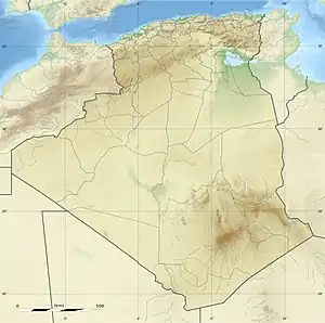
Chott Ech Chergui (Arabic: شط الشرقي) is a large endorheic salt lake in Saïda Province, northwestern Algeria.[2] It is located at 34.35°N 0.5°E in the level terrain of the Hautes Plaines region between the Tell Atlas and the Saharan Atlas and is one of the largest lakes in Algeria.
| Chott Ech Chergui | |
|---|---|
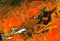 from space | |
 Chott Ech Chergui Chott ach-Chargui in Algeria | |
| Coordinates | 34.35°N 0.5°E |
| Type | Endorheic salt lake |
| Native name | شط الشرقي |
| Basin countries | Algeria |
| Max. length | 160 km (99 mi) |
| Max. width | 24 km (15 mi) |
| Surface area | 2,000 km2 (770 sq mi) |
| Surface elevation | 1,027 m (3,369 ft) above sea level |
| Designated | 2 February 2001 |
| Reference no. | 1052[1] |
Ecology
The Chott Ech Chergui has an area of about 2000 km² where water collects during the wet season, forming a number of large shallow salt lakes which become salt flats as they dry. The lake area has a length of about 160 km from ENE to WSW and lies at an average elevation of 1000 m.[3]
Chott Ech Chergui has been designated a Ramsar wetland of international importance. The Ramsar site has an area of 8555 km² and is the natural environment for a number of threatened and vulnerable animal and plant species.[4]
See also
References
- "Chott Ech Chergui". Ramsar Sites Information Service. Retrieved 25 April 2018.
- Chott ech Chergui - Wilaya de Saida
- Magdi Masgidi & Shafi Noor Islam, Wetlands Management in Algeria: A Case Study on Chott Ech Chergui.
- Wetlands of International Importance: Algeria, Chott Ech Chergui
External links
- (in English) Ramsar Convention website
- (in French) Direction Générale des Forêts