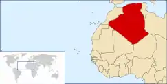
Geography of Algeria
Algeria comprises 2,381,741 square kilometers of land, more than four-fifths of which is desert, in northern Africa, between Morocco and Tunisia. It is the largest country in Africa. Its Arabic name, Al Jazair (the islands), derives from the name of the capital Algiers (Al Jazair in Arabic), after the small islands formerly found in its harbor. It has a long Mediterranean coastline. The northern portion, an area of mountains, valleys, and plateaus between the Mediterranean Sea and the Sahara Desert, forms an integral part of the section of North Africa known as the Maghreb. This area includes Morocco, Tunisia, and Libya.
  | |
| Continent | Africa |
|---|---|
| Region | North Africa |
| Coordinates | 28°00′N 3°00′E |
| Area | Ranked 10th |
| • Total | 2,381,741 km2 (919,595 sq mi) |
| • Land | 100% |
| • Water | 0% |
| Coastline | 1,622 km (1,008 mi) |
| Borders | Land boundaries: 6,343 km Morocco 1,559 km, Mali 1,376 km, Libya 982 km, Tunisia 965 km, Niger 956 km, Mauritania 463 km, Western Sahara 42 km |
| Maritime claims | 32–52 nm |
| Highest point | Mount Tahat, 2,908 m |
| Lowest point | Chott Melrhir, −40 m |
| Longest river | Chelif River, 230 km |
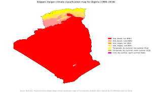
| Climate | arid to semiarid |
| Terrain | mostly high plateau and desert, mountains, narrow coastal plain |
| Natural Resources | petroleum, natural gas, iron ore, phosphates, uranium, lead, zinc |
| Natural Hazards | earthquakes, mudslides, floods, droughts |
| Environmental Issues | soil erosion, desertification, pollution |
| Exclusive economic zone | 126,353 km2 (48,785 sq mi) |
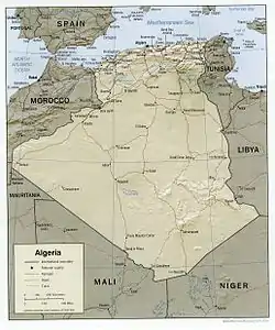
Size and boundaries
Land boundaries:
Total: 6,764 km (4,203 mi)
Border countries: Libya 989 km (615 mi), Mali 1,359 km (844 mi), Mauritania 460 km (290 mi), Morocco 1,559 km (969 mi), Niger 951 km (591 mi), Tunisia 1,034 km (642 mi), Western Sahara 41 km (25 mi).
Area – comparative: roughly 3.5 times the size of the US state of Texas and twice the size of the Canadian province of Ontario.
Coastline: 1,622 km (1,008 mi)
Maritime claims:
Exclusive economic zone: 126,353 km2 (48,785 sq mi)
Territorial sea: 12 nmi (22.2 km)
Geographic region
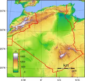
Tell Atlas, High Plateaus and the Saharan Atlas
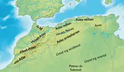
Stretching from the Moroccan border the Tell Atlas, including the Djebel Babor formation, is the dominant northwestern mountain range. Stretching more than 600 kilometers eastward from the Moroccan border, the high plateau area (often referred to by the French name Hautes Plaines or Hauts Plateaux) consist of undulating, steppe-like plains lying between the Tell and Saharan Atlas ranges. The elevation averages between 1,100–1,300 metres (3,600–4,300 ft) in elevation in the west, dropping to 400 metres (1,300 ft) in the east. The climate is so dry that these plains are sometimes thought of as part of the Sahara. The plateau area is covered by alluvial debris formed when the mountains eroded. An occasional ridge projects through the alluvial cover to interrupt the monotony of the landscape.[1]
Higher and more continuous than the Tell Atlas, the Sahara Atlas range is formed of three massifs: the Ksour Range near the Moroccan border, the Amour Range, and the Ouled-Naïl Range south of Algiers. The mountains, which receive more rainfall than those of the High Plateaus, include some good grazing land. Watercourses on the southern slopes of these massifs disappear into the desert but supply the wells of numerous oases along the northern edge of the desert, of which Biskra, Laghouat, and Béchar are the most prominent.
Northeastern Algeria
Eastern Algeria consists of a massive area extensively dissected into mountains, plains, and basins. It differs from the western portion of the country in that its prominent topographic features do not parallel the coast. In its southern sector, the steep cliffs and long ridges of the Aurès Mountains create an almost impenetrable refuge that has played an important part in the history of the Maghrib since Roman times. Near the northern coast, the Petite Kabylie Mountains are separated from the Grande Kabylie range at the eastward limits of the Tell by the Soummam River. The coast is predominantly mountainous in the far eastern part of the country, but limited plains provide hinterlands for the port cities of Bejaïa, Skikda, and Annaba. In the interior of the region, extensive high plains mark the region around Sétif and Constantine; these plains were developed during the French colonial period as the principal centers of grain cultivation. Near Constantine, salt marshes offer seasonal grazing grounds to seminomadic sheep herders.
The Sahara
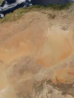
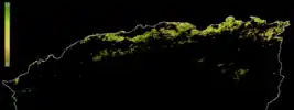
The Algerian portion of the Sahara extends south of the Saharan Atlas for 1,500 kilometres (930 mi) to the Niger and Mali frontiers. The desert is an otherworldly place, scarcely considered an integral part of the country. Far from being covered wholly by sweeps of sand, however, it is a region of great diversity. Immense areas of sand dunes called areg (sing., erg) occupy about one-quarter of the territory. The largest such region is the Grand Erg Oriental (Great Eastern Erg), where enormous dunes two to five metres (6.6 to 16.4 ft) high are spaced about 40 metres (130 ft) apart. Much of the remainder of the desert is covered by rocky platforms called humud (sing., hamada), and almost the entire southeastern quarter is taken up by the high, complex mass of the Ahaggar and Tassili n'Ajjer highlands, some parts of which reach more than 2,000 metres (6,600 ft). Surrounding the Ahaggar are sandstone plateaus, cut into deep gorges by ancient rivers, and to the west a desert of pebbles stretches to the Mali frontier.
The desert consists of readily distinguishable northern and southern sectors, the northern sector extending southward a little less than half the distance to the Niger and Mali frontiers. The north, less arid than the south, supports most of the few persons who live in the region and contains most of the desert's oases. Sand dunes are the most prominent features of this area's topography, but between the desert areas of the Grand Erg Oriental and the Grand Erg Occidental (Great Western Erg) and extending north to the Atlas Saharien are plateaus, including the Tademaït and a complex limestone structure called the M'zab where the Mozabite Berbers have settled. The southern zone of the Sahara is almost totally arid and is inhabited only by the Tuareg nomads and, recently, by oil camp workers. Barren rock predominates, but in some parts of Ahaggar and Tassili n'Ajjer alluvial deposits permit garden farming.
Climate and hydrology
Northern Algeria is in the temperate zone and enjoys a mild, Mediterranean climate. It lies within approximately the same latitudes as southern California and has somewhat similar climatic conditions. Its broken topography, however, provides sharp local contrasts in both prevailing temperatures and incidence of rainfall. Year-to-year variations in climatic conditions are also common.[2] This area, the most inhabited in Algeria, is commonly referred to as the Tell.
In the Tell, temperatures in summer average between 21 and 42 °C (70 and 108 °F) and in winter drop to 10 to 12 °C (50 to 54 °F). Winters are not cold, but the humidity is high and houses are seldom adequately heated. In eastern Algeria, the average temperatures are somewhat lower, and on the steppes of the High Plateaus winter temperatures hover only a few degrees above freezing. A prominent feature of the climate in this region is the sirocco, a dusty, choking south wind blowing off the desert, sometimes at gale force. This wind also occasionally reaches into the coastal Tell.[2]
In Algeria only a relatively small corner of the Sahara lies across the Tropic of Cancer in the torrid zone, but even in winter, midday desert temperatures can be very hot. After sunset, however, the clear, dry air permits rapid loss of heat, and the nights are cool to chilly. Enormous daily ranges in temperature are recorded.[2]
Rainfall is fairly abundant along the coastal part of the Tell, ranging from 400 to 670 mm (15.7 to 26.4 in) annually, the amount of precipitation increasing from west to east. Precipitation is heaviest in the northern part of eastern Algeria, where it reaches as much as 1,000 mm (39.4 in) in some years. Farther inland the rainfall is less plentiful. Prevailing winds that are easterly and northeasterly in summer change to westerly and northerly in winter and carry with them a general increase in precipitation from September to December, a decrease in the late winter and spring months, and a near absence of rainfall during the summer months.[2]
Terrain
| Land Use | (2014 est.) |
|---|---|
| • Arable land | 18.02% |
| • Permanent crops | 2.34% |
| • Permanent pastures | 79.63% |
| • Forest | 0.82% |
| • Other | 81.80% |
| Irrigated Land | 13,600 km2 (5,300 sq mi) |
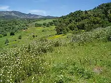
Clearing of land for agricultural use and cutting of timber over the centuries have severely reduced the once bountiful forest wealth. Forest fires have also taken their toll. In the higher and wetter portions of the Tell Atlas, cork oak and Aleppo pine grow in thick soils. At lower levels on thinner soils, drought-resistant shrubs predominate. The grapevine is indigenous to the coastal lowlands, and grasses and scrub cover the High Plateaus. On the Saharan Atlas, little survives of the once extensive forests of Atlas cedar that have been exploited for fuel and timber since antiquity.
The forest reserves in Algeria were severely reduced during the colonial period. In 1967 it was calculated that the country's forested area extended over no more than 24,000 square kilometres (9,300 sq mi) of terrain, of which 18,000 km2 (6,900 sq mi) were overgrown with brushwood and scrub. By contrast, woodlands in 1830 had covered 50,000 km2 (19,000 sq mi). In the mid-1970s, however, the government embarked on a vast reforestation program to help control erosion, which was estimated to affect 100,000 cubic metres (3,500,000 cu ft) of arable land annually. Among projects was one to create a barrage vert (green barrier) more or less following the ridge line of the Saharan Atlas and extending from Morocco to the Tunisian frontier in a zone 1,500 kilometres (930 mi) long and up to 20 kilometres (12 mi) wide.
The barrage vert consists principally of Aleppo pine, a species that can thrive in areas of scanty rainfall. It is designed to restore a damaged ecological balance and to halt the northern encroachment of the Sahara. By the early 1980s, the desert had already penetrated the hilly gap between the Saharan Atlas and the Aurès Mountains as far as the town of Bou Saâda, a point well within the High Plateaus region. The barrage vert project was ended in the late 1980s because of lack of funds.
Algeria had a 2018 Forest Landscape Integrity Index mean score of 5.22/10, ranking it 106th globally out of 172 countries.[3]
Statistics
Natural resources: petroleum, natural gas, iron ore, phosphates, uranium, lead, zinc
Total renewable water resources: 11.67 km3 (2.80 cu mi) (2011)
Freshwater withdrawal (domestic/industrial/agricultural)
Total: 5.72 km3/yr (1.37 cu mi/yr) (22%/13%/65%)
Per capita: 182 m3/yr (6,400 cu ft/yr) (2005)
Natural hazards: mountainous areas subject to severe earthquakes; mudslides and floods in rainy season
Environment – current issues: soil erosion from overgrazing and other poor farming practices; desertification; dumping of raw sewage, petroleum refining wastes, and other industrial effluents is leading to the pollution of rivers and coastal waters; Mediterranean Sea, in particular, becoming polluted from oil wastes, soil erosion, and fertilizer runoff; inadequate supplies of potable water
Environment – international agreements: party to: Biodiversity, Climate Change, Desertification, Endangered Species, Environmental Modification, Hazardous Wastes, Law of the Sea, Ozone Layer Protection, Ship Pollution, Wetlands signed, but not ratified: Nuclear Test Ban
Protected areas
Algeria has a number of protected areas including National Parks and nature reserves. An example of such a protected area is the Djebel Babor Nature Reserve within the Djebel Babor Mountains;[4] the Djebel Babor is also one of the few relict habitats for the endangered Barbary macaque, Macaca sylvanus.[5]
The national parks in Algeria are: Ahaggar, Belezma, Chréa, Djurdjura, El Kala, Gouraya, Tassili n'Ajjer, Taza, Théniet El Had, and Tlemcen.
Extreme points
Elevation extremes:
- Lowest point: Chott Melrhir: −40 metres (−130 ft)
- Highest point: Mount Tahat: 3,003 metres (9,852 ft)
Points that are farther north, south, east or west than any other location:
- Northernmost point – Cap Takouch, Annaba Province or Cap Bougaroûn, Skikda province
- Easternmost point – the tripoint with Niger and Libya, Tamanghasset Province
- Southernmost point – unnamed location on the border with Mali east of the Malian village of In-Abalen, Adrar Province
- Westernmost point – the western section of the border with Morocco/Western Sahara, Tindouf Province (Note: Algeria does not have a westernmost point, the border being formed by a line of longitude)
References
 This article incorporates public domain material from the Library of Congress Country Studies website http://lcweb2.loc.gov/frd/cs/.
- This article incorporates public domain material from the United States Department of State website https://www.state.gov/countries-areas/. (U.S. Bilateral Relations Fact Sheets)
- CIA World Factbook (2014) United States Government Printing Office, Washington, D.C.
- C. Michael Hogan, (2008) Barbary Macaque: Macaca sylvanus, Globaltwitcher.com, ed. N. Strõmberg
- "Mediterranean conifer and mixed forests". Terrestrial Ecoregions. World Wildlife Fund.
- Soil Maps of Algeria European Digital Archive on the Soil Maps of the world
References
- Les Hautes Plaines algéro-marocaines et le Maroc central
- "Algeria - Climate and Hydrology". countrystudies.us. US Library of Congress. Retrieved 18 February 2018. This article incorporates text from this source, which is in the public domain.
- Grantham, H. S.; Duncan, A.; Evans, T. D.; Jones, K. R.; Beyer, H. L.; Schuster, R.; Walston, J.; Ray, J. C.; Robinson, J. G.; Callow, M.; Clements, T.; Costa, H. M.; DeGemmis, A.; Elsen, P. R.; Ervin, J.; Franco, P.; Goldman, E.; Goetz, S.; Hansen, A.; Hofsvang, E.; Jantz, P.; Jupiter, S.; Kang, A.; Langhammer, P.; Laurance, W. F.; Lieberman, S.; Linkie, M.; Malhi, Y.; Maxwell, S.; Mendez, M.; Mittermeier, R.; Murray, N. J.; Possingham, H.; Radachowsky, J.; Saatchi, S.; Samper, C.; Silverman, J.; Shapiro, A.; Strassburg, B.; Stevens, T.; Stokes, E.; Taylor, R.; Tear, T.; Tizard, R.; Venter, O.; Visconti, P.; Wang, S.; Watson, J. E. M. (2020). "Anthropogenic modification of forests means only 40% of remaining forests have high ecosystem integrity - Supplementary Material". Nature Communications. 11 (1). doi:10.1038/s41467-020-19493-3. ISSN 2041-1723.
- National Wildlife Federation, 2001
- C. Michael Hogan, 2008